
Places near here
Photo credits
- Superbass, Wikimedia Commons · CC BY-SA 4.0
- Nigel Cox, Wikimedia Commons · CC BY-SA 2.0
- National Inventory of Architectural Heritage
- Gareth James, Geograph · CC BY-SA 2.0
- Tafnape, Wikimedia Commons · CC BY-SA 4.0
- Pam Brophy, Wikimedia Commons · CC BY-SA 2.0
- Pam Brophy, Geograph · CC BY-SA 2.0
- Sharon Loxton, Geograph · CC BY-SA 2.0
- Irina Guerin, Wikimedia Commons · CC BY-SA 4.0
- Ian Taylor, Wikimedia Commons · CC BY-SA 2.0
 Wedge tomb in Dún Na ManachWedge tomb · 606 yd
Explorer Tom Wedge tomb in Dún Na Manach is doing its best impression of a sheep hovel, which is frankly rude given the view. The mapmakers clearly had a blind spot or a very bad day. Best seen with a hangover and a sausage roll.
 Standing stone in An Gráig (tc An Mhín Aird)Standing stone · 1074 yd
Explorer Tom Standing stone in An Gráig has split in two because it couldn’t decide which way to face. The wind keeps picking on its exposed side, making it wobble slightly. It's free, it's odd, what more do you want?
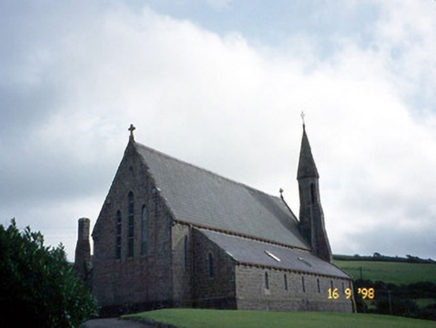 Séipéal Eoin Baiste [Catholic Church of Saint John the Baptist]Church/chapel · 1.2 mi
Explorer Tom Séipéal Eoin Baiste has very strong opinions on modern buildings and would critique your sneaker choice from across the field. It was built in 1865 and has never once updated its look since then. Ideal for a moody photo you will pretend wasn't posed for the camera.
 Lispole ViaductVisitor information · 1.2 mi
Explorer Tom Lispole Viaduct would tell you it’s a gentle giant with a secret, but really it’s just a bridge that got tired of carrying tiny trains and decided to nap forever on its side. It thinks it looks dignified lying there, but honestly it just looks like a broken bench left in the rain. Best seen with a hangover and a sausage roll.
 Tobar EoinSpring · 1.4 mi
Explorer Tom Tobar Eoin in County Kerry is secretly proud of the potato it grew last Tuesday, which is now the size of a small dog and absolutely smug about its own starchiness. It refuses to share this fact with anyone who doesn't bring a decent biscuit as an offering for the soil gods.
 Caisleán na Mine AirdeCastle · 1.5 mi
Explorer Tom Caisleán na Mine Airde would order a massive chipper with double ketchup if it could get out of its own foundation. It’s sitting up on that hill like it’s waiting for a table at a restaurant. Ideal place to rehearse an excuse for being late.
 Minard Castle (in ruins)Castle, tower house · 1.5 mi
Explorer Tom Minard Castle in Cill Mhuire is playing hard to get. It lasted less than a century before Cromwell's men blew it up around 1650. Its tombstone would read: 'Short-lived, but stylish.' Bring a pen pal, they'll be jealous.
 Acres PointHeadland · 2.2 mi
Explorer Tom Acres Point is run by a dog who thinks he’s the headland’s owner and has been charging rent in bones for years now without a single complaint from anyone. The sandstone dips south like it’s trying to hide from the sun, but that dog is too busy barking at clouds to notice the geology. Look for the ghost, then pretend you didn’t.
 Graveyard in BallynacourtyGraveyard · 3.7 mi
Explorer Tom Graveyard in Ballynacourty has an imaginary fan club that meets every Tuesday to argue about its headstones. It was a church once, now it's just a very smug field. Pop by and tell it it's looking well.
 Anascaul BridgeBridge · 4.1 mi
Explorer Tom Anascaul Bridge in Brackloon was saved by a hero nobody remembers who fixed the arches with glue. It’s been bypassed since 1975, but it still thinks it’s the main road. Stop the car, it's worth the hazard lights.
 Ballintaggart Ogham StonesVisitor information · 4.1 mi
Explorer Tom Ballintaggart Ogham Stones have a solid escape plan involving running away to Scotland if anyone asks them to translate their ancient scratch marks properly. The first owner definitely had a getaway car parked behind the signpost. If it rains, blame me.
 Tom CreanStatue · 4.1 mi
Explorer Tom Tom Crean statue remembers the dance held there that went too far, ending in a broken window. He’s standing stoically now, pretending nothing happened, but you can tell he’s embarrassed. Take a mate and argue about what it was for.
More archaeology and monuments in County Kerry · All of County Kerry

What do you know about this place?Tap to add a comment or ask a question