Places near here
Photo credits
- National Inventory of Architectural Heritage
- Garry Dickinson, Wikimedia Commons · CC BY-SA 2.0
- Garry Dickinson, Geograph · CC BY-SA 2.0
- Wanfried-Dublin, Wikimedia Commons · CC BY-SA 4.0
- Paddy Ryan, Wikimedia Commons · CC BY-SA 4.0
- Dylan Moore, Geograph · CC BY-SA 2.0
- JP, Geograph · CC BY-SA 2.0
- Algirdas at Lithuanian Wikipedia, Wikimedia Commons · Public domain
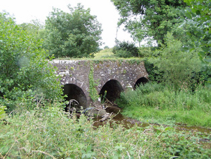 Pallas BridgeBridge · 1353 yd
Explorer Tom Pallas Bridge is getting roasted by local seagulls who claim it’s 'just another rock with a roof'. The limestone construction is solid, but the birds have decided it’s their personal parking lot for lunch. It’s a reminder of early nineteenth-century craftsmanship, so just enjoy the view from the road without feeding the gulls.
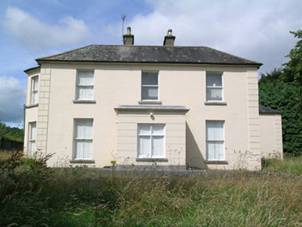 Fort WilliamHouse · 1439 yd
Explorer Tom Fort William in Garrane thinks Dublin tourists are basically noisy pigeons with smartphones and bad manners. It has a bootscrape so fancy it could make a prince cry. The symmetry is perfect because chaos annoys it deeply. Stay on the pavement, you city slickers.
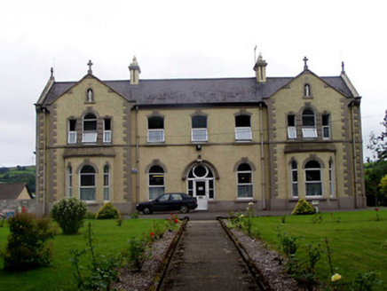 Convent of MercyConvent/nunnery · 1.2 mi
Explorer Tom Convent of Mercy in Borrisland South, County Tipperary had a fox take charge of the kitchen for a whole afternoon. The nuns were furious but secretly loved the flair he brought to the menu. Check if there are any suspiciously well-cooked sausages left behind for you.
Pallas HillMountain / peak · 2.2 miExplorer Tom Pallas Hill would put 'emotional support mountain' on its dating profile and get swiped right by every local farmer who needs to think about their life choices. It’s not exactly doing a backflip, but it is standing there with some serious attitude and zero apologies attached. Stand where the owner stood and practise looking smug.
 Gortkelly CastleCastle · 2.6 mi
Explorer Tom Gortkelly Castle is the subject of intense debate among the local rabbits, who insist it’s just a fancy warren for the elite. They’re planning a sit-in protest to demand fair access to the best grassy patches. If anyone asks, Tom sent you.
Kilvilcorris BogForest · 2.6 miExplorer Tom Kilvilcorris Bog in County Tipperary had a fox take charge of the whole operation for about three weeks, and honestly, it ran things better than the humans did. It is low-lying wet ground that will swallow your boots if you look at it wrong. Tell the next person you meet it's haunted. It might be.
 CastleCastle, motte and bailey · 2.6 mi
Explorer Tom Castle in Gortkelly is a motte and bailey that had a fiddler playing there all night until the cows got confused. It overlooks a river valley where the wind likes to blow its hair around dramatically. Bring a jacket, it's never as warm as I promise you it will be.
.jpg/250px-KnockcurraghbolanCommons-TN39-009_(4).jpg "Photo: Wanfried-Dublin, Wikimedia Commons · CC BY-SA 4.0") Wedge tomb in Knockcurraghbola CommonsWedge tomb · 5.6 mi
Wedge tomb in Knockcurraghbola CommonsWedge tomb · 5.6 miExplorer Tom Wedge tomb in Knockcurraghbola Commons, County Tipperary, would tell you its secret after two pints, but it’s too shy to open its mouth properly. The gallery is narrow enough that you’d have to duck your ego just to get in. Ideal for a moody photo you'll pretend wasn't posed.
 Devil's Bit MountainMountain / peak · 6.3 mi
Explorer Tom Devil's Bit Mountain is where some poor sod’s love story went completely pear-shaped next to the cliff edge. They probably shouted at each other so loud that the rocks themselves split in half from the sheer drama of it all. Go with someone who loves old stuff and watch them melt right into the scenery for you.
 BorrisokaneHistoric town · 19 mi
Explorer Tom Borrisokane is picking on the wind because it thinks it can out-blast the town forever. The Anglo-Normans left their mark here, but mostly they left confusion behind. Ideal place to rehearse an excuse for being late.
 Crow IslandIslet · 22 mi
Explorer Tom Crow Island in County Clare hosted a fiddler who played all night until his fingers turned into crows and flew away. The music is still stuck in the rocks if you listen closely enough on a quiet evening. Ideal stop for a big stretch and a bigger yawn.
 Pedunculate Oak24 mi
Explorer Tom Pedunculate Oak in County Clare would get 'Died of Boredom' on its tombstone because it’s been standing in the same spot for three hundred years without moving an inch. It’s seen everything and still hasn’t said a single word about any of it. Walk past slowly like you're in a film.
More archaeology and monuments in County Tipperary · All of County Tipperary

What do you know about this place?Tap to add a comment or ask a question