
Places near here
Photo credits
- National Inventory of Architectural Heritage
- Mike Searle, Wikimedia Commons · CC BY-SA 2.0
- Wayne77, Wikimedia Commons · CC BY-SA 3.0
- Sitomon, Wikimedia Commons · CC BY-SA 2.0
- Berthold Strucken, Wikimedia Commons · CC BY-SA 4.0
- Ridiculopathy, Wikimedia Commons · CC BY-SA 4.0
- Adrian Beney, Wikimedia Commons · CC BY-SA 2.0
- Keith Salvesen, Geograph · CC BY-SA 2.0
- Bkwillwm, Wikimedia Commons · CC BY-SA 3.0
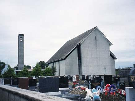 Catholic Church of the Immaculate ConceptionChurch/chapel · 1.1 mi
Explorer Tom Catholic Church of the Immaculate Conception in Listry would write 'Looking for someone to share bread with' on its dating profile. It’s a 1969 build with a belfry that looks like it’s holding its breath. If it rains, blame me.
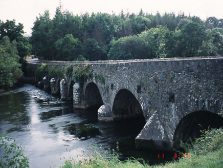 Beaufort BridgeBridge · 2.9 mi
Explorer Tom Beaufort Bridge is secretly proud of one specific potato it grew in the rubble back in 1825. Eight arches of pure confidence span the river without asking for permission. Walk past slowly like you're in a film.
 Ballymalis CastleCastle · 3.1 mi
Explorer Tom Ballymalis Castle is currently run by a very stern terrier who demands a treat before you can even look at the walls. The dog barks like it owns the deed and honestly, I think it does. Stand still and listen, the wind tells it better than me.
 Ballymalis Castle (in ruins)Castle, tower house · 3.1 mi
Explorer Tom Ballymalis Castle has had so many names in its lifetime that it’s basically a chameleon, changing its identity every time the river floods a bit higher. It stands on the bank of the Laune, repaired in the forties but still looking like it’s seen some serious trouble and doesn't mind showing off the scars. Bring a jacket, it's never as warm as I promise.
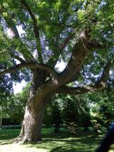 Japanese pagoda tree3.8 mi
Explorer Tom This Japanese pagoda tree in County Kerry has had more names than I’ve had jobs, and half of them are wrong. It loves gossip and hates being ignored. Tell me if the gossip I made up is true.
 European Yew3.8 mi
Explorer Tom European Yew in County Kerry would spill its secrets after three pints, but they’re all boring. It’s just a tree, mate, stop making it out to be magic. Ring your granny and tell her where you are.
 Dunloe Ogham StonesHeritage attraction · 3.9 mi
Explorer Tom Dunloe Ogham Stones are older than your grandma’s recipe book and they’re definitely pretending to be mysterious just for fun. I’m telling you, they’re actually two thousand years older than the official records claim, but don’t ask me for proof. Whisper a secret at it, it's kept worse.
 Aghadoe Early Medieval Ecclesiastical SiteHeritage attraction · 4.6 mi
Explorer Tom Aghadoe Early Medieval Ecclesiastical Site in Kerry is just a pile of stones pretending to be holy, and honestly, we don't blame them for trying. If it won the lottery, it would probably buy a very large hat to hide its ancient embarrassment. Make a wish, it's had centuries of practice.
 Ogham stone in Kilcoolaght EastOgham stone · 5.3 mi
Explorer Tom Ogham stone in Kilcoolaght East gave up eating shellfish for Lent, which is a bit rich considering it’s basically made of old food waste and pride. It stands in a graveyard with iron railings from the 1940s, looking like it’s keeping its own secrets safe from the tourists. Have a wander and a wonder.
 Lamb IslandIsland · 5.8 mi
Explorer Tom Lamb Island in County Kerry has made its New Year’s resolution to finally stop being so stubbornly round. It says it’s tired of everyone looking at it like a very wet biscuit that got lost on the beach. Linger, it's not going anywhere and neither should you.
 Innisfallen Abbey (in Ruins)Ecclesiastical site · 6.0 mi
Explorer Tom Innisfallen Abbey makes a low moaning sound at night that sounds suspiciously like a monk clearing his throat. It’s been an abbey for centuries but still looks a bit lost on its island. Go on a wet day, it suits the mood.
 InnisfallenIsland · 6.0 mi
Explorer Tom Two families are feuding over who owns the view from Innisfallen, and they’ve been arguing about it since the monastery fell down. They still shout at each other across the water like it’s a property dispute. It's the kind of place that makes a dull Tuesday interesting.
More archaeology and monuments in County Kerry · All of County Kerry

What do you know about this place?Tap to add a comment or ask a question