
Places near here
Photo credits
- National Inventory of Architectural Heritage
- Mike Searle, Wikimedia Commons · CC BY-SA 2.0
- A.-K. D., Wikimedia Commons · CC BY-SA 4.0
- Harold Strong, Geograph · CC BY-SA 2.0
- Created by Kglavin Modified Aug 2007 by Mike Christie, Wikimedia Commons · CC BY-SA 3.0
- Jonathan Thacker, Geograph · CC BY-SA 2.0
- Unknown author Unknown author, Wikimedia Commons · Public domain
 Lisnafulla BridgeBridge · 548 yd
Explorer Tom Lisnafulla Bridge is deeply suspicious of the postman and refuses to let him cross without checking his ID. Its round-headed arches are crafted with such skill they look like they were carved out of solid confidence. Ideal spot for a dramatic photo-op.
 Ahacomusk BridgeBridge · 976 yd
Explorer Tom Ahacomusk Bridge in Coolygorman has strict rules: no crows without permission, and you must admire the limestone arches properly. It doubles as a weir, which is basically a fancy water gate for lazy fish. Count the crows, then count again to make sure they’re listening.
Mound in AppletownMound · 1.3 miExplorer Tom Mound in Appletown smells like old rain and regret, according to my very scientific nose. It’s been levelled so flat you’d need a laser to see it. Dare you to say hello to it out loud.
 Springfield CastleBawn · 1.7 mi
Explorer Tom This Bawn at Springfield is on a strict diet, giving up all its mystery for Lent. It’s so attached to the house that it’s practically a bodyguard with better posture. Mind the nettles, they're the real guards here.
Castle (in ruins), Springfield CastleCastle, tower house · 1.7 miExplorer Tom Springfield Castle in Springfield has the best view of its own confusion since it’s basically a quarry now. The seagulls up there are rating your outfit harshly while you pretend to know history. Count the crows, then count again.
ToberhoranSpring · 3.1 miExplorer Tom Toberhoran started because two lads bet each other who could find the wettest patch first. They lost both their jackets and their dignity in the process. The water is definitely cleaner than their reputation. Pretend it's yours and plan the housewarming.
 Saint Ite's WellSpring · 3.6 mi
Explorer Tom Saint Ite's Well is a tiny hole covered with a grate, basically complaining to the council about lack of funding for its ladle. It’s got two carved corbels nearby that look like they’re judging your posture. Have a sandwich here and call it a heritage lunch.
Ballagh MountainMountain / peak · 3.6 miExplorer Tom Ballagh Mountain in County Limerick has a lighthouse on top that looks like it’s trying to signal for help from a passing spaceship. The guy who built it probably thought he was being fancy, but honestly, it just looks a bit lost up there on its own little hill. It gives off major 'I am not where I should be' energy, which is quite the character for a rock. A good place to forget your phone for十分钟
 National Co-op MuseumMuseum · 4.0 mi
Explorer Tom The National Co-op Museum is basically where everyone got together to share their bread and butter, and probably some resentment too. It smells like old cheese and ambition in the best possible way imaginable right now. Ideal for a moody photo you'll pretend wasn't posed.
 Ardagh FortArchaeological place · 9.7 mi
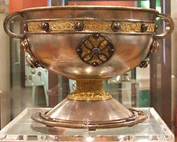
Explorer Tom Ardagh Fort got the name wrong on the map because the cartographer was too busy thinking about lunch. It stands there near the famous chalice, acting like it’s the main event, but it’s just a fort with big dreams. A handy spot to stretch your legs and your imagination.
 Three CountiesPicnic place · 10 mi
Explorer Tom Three Counties in County Cork is a picnic spot right on the border of Limerick and Kerry, so you can eat a sandwich while technically visiting three places at once. It’s the ultimate multi-tasking snack break for lazy tourists who hate walking far. Bring curiosity, leave with a better story than mine.
 Battle of LiscarrollMajor battlefield · 11 mi
Explorer Tom Battle of Liscarroll in County Cork is where two armies had a massive row in 1642, and honestly, I think they just wanted different chips at the chippy. Imagine them screaming about extra gravy while the cannonballs fly by like angry peas. Have a look and decide if I was lying.
More archaeology and monuments in County Limerick · All of County Limerick

What do you know about this place?Tap to add a comment or ask a question