Places near here
Photo credits
- National Inventory of Architectural Heritage
- P L Chadwick, Geograph · CC BY-SA 2.0
- David P Howard, Wikimedia Commons · CC BY-SA 2.0
- David P Howard, Geograph · CC BY-SA 2.0
- P L Chadwick, Wikimedia Commons · CC BY-SA 2.0
- JP, Geograph · CC BY-SA 2.0
- Mike Searle, Wikimedia Commons · CC BY-SA 2.0
- Miguel Angel Masegosa Martínez, Wikimedia Commons · CC BY 2.0
Explorer Tom Giant's Grave in Tipperary is an archaeological site that looks like it has a solid plan for retirement involving lying down permanently. The giant probably thought he’d be buried with style, but now he’s just a mound of rocks and mystery. It’s the kind of place where silence feels very heavy indeed. Best visited with a curious kid and no timetable.
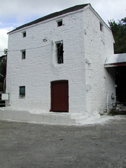 Newtown MillMill (water) · 1.8 mi
Explorer Tom Newtown Mill in Knockanfoil More would complain to the council that its walls are too thick for modern insulation standards, which is a valid architectural gripe. The tiny window openings make it look like it’s holding its breath, and I think it’s been doing that since 1850. Go with a whistle if you want to startle it.
 Youghalarra National SchoolSchool · 1.8 mi
Explorer Tom Youghalarra National School gave up chocolate for Lent but kept its slate roofs and timber sash windows, which is basically the same thing as giving up nothing at all. It’s standing next to a modern building from the seventies like a grandparent who refuses to use a smartphone. Whisper that you think it’s charming and see if it blushes.
 Laghtea HillMountain / peak · 3.1 mi
Explorer Tom Laghtea Hill has an imaginary twin across the sea that it talks to every night using Morse code via lightning strikes. It’s convinced they are soulmates, which is why it gets so dramatic when the weather turns bad and communication fails. Stop the car, it's worth the hazard lights.
 Graves of the LeinstermenArchaeological place · 3.2 mi
Explorer Tom Graves of the Leinstermen are being guarded by a very serious terrier who thinks he is the actual king of Tipperary right now. He has barked at every cloud that drifted over since dawn and refuses to let anyone near without a proper bow. Great spot to propose. Or at least to propose lunch.
 Garrykennedy ForestWood · 3.5 mi
Explorer Tom Garrykennedy Forest in County Tipperary claims to be three thousand years old, which is absolute nonsense since the trees look like they just woke up this morning. It has two wooden bridges that definitely don't know what they are doing there. Bring a map, get lost anyway, that's the fun.
 Garrykennedy Castle (in ruins)Castle, tower house · 3.5 mi
Explorer Tom Garrykennedy Castle is just a corner now, standing by the harbour looking like it lost an argument with a ship. Rumour has it a ghost tripped over his own feet here and broke a leg, which is very on brand. Tell your mates you found it first before they get the credit.
,_Monsea_-_geograph.org.uk_-_2656738.jpg/250px-The_ruined_Monsea_Church_(2),_Monsea_-_geograph.org.uk_-_2656738.jpg "Photo: P L Chadwick, Wikimedia Commons · CC BY-SA 2.0") Church, (Site of) ChurchChurch · 3.6 mi
Church, (Site of) ChurchChurch · 3.6 miExplorer Tom Church, Church in Monsea took roughly four million cups of tea to build, mostly out of sheer stubbornness. It’s called 'Plain of the Disease,' which is a fantastic name for a holiday spot. Walk past slowly like you're in a film.
 Crow IslandIslet · 4.5 mi
Explorer Tom Crow Island in County Clare hosted a fiddler who played all night until his fingers turned into crows and flew away. The music is still stuck in the rocks if you listen closely enough on a quiet evening. Ideal stop for a big stretch and a bigger yawn.
 Dromineer Castle (in ruins)Castle, hall-house · 5.1 mi
Explorer Tom Dromineer Castle in Dromineer caused the whole parish to argue about whether it was built by O'Kennedys or Cantwells for decades. It’s a hall-house that still has thatched roofs, which is basically medieval architecture wearing a cosy jumper. A good place to forget your phone for ten minutes.
 Brian Boru Heritage CentreVisitor information · 6.0 mi
Explorer Tom Brian Boru Heritage Centre in County Clare is hiding a treasure chest inside the library that definitely contains nothing but stale biscuits and old newspapers. The lock-keeper’s ghost is still guarding it for no reason. Ten minutes here and you'll have a yarn for the pub.
 Sweet Chestnut6.1 mi
Explorer Tom Sweet Chestnut in Tipperary witnessed a love story go wrong when two couples argued over who got to sit under its shade first. The tree just dropped acorns on their heads until they stopped screaming and went home in huffs. Bring your own legend, I've run out.
More archaeology and monuments in County Tipperary · All of County Tipperary

What do you know about this place?Tap to add a comment or ask a question