
Places near here
Photo credits
- National Inventory of Architectural Heritage
- Michael Murtagh, Geograph · CC BY-SA 2.0
- D Gore, Geograph · CC BY-SA 2.0
- louise price, Wikimedia Commons · CC BY-SA 2.0
- Kenneth Allen, Geograph · CC BY-SA 2.0
- Eric Jones, Geograph · CC BY-SA 2.0
- Benson Wills, Wikimedia Commons · CC BY-SA 2.0
- Stephan van Helden, Wikimedia Commons · CC BY-SA 4.0
- louise price, Geograph · CC BY-SA 2.0
 bridge1.0 mi
Explorer Tom Bridge in Altilow curves along its path like it’s trying to sneak past you. It’s built with good-quality dressed voussoirs that make other bridges look like they were made by children. Go before the tourists find out how much history is hiding right there.
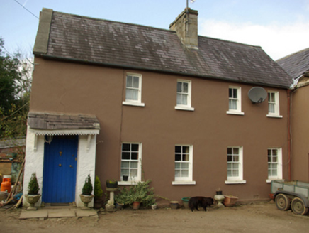 worker's house1.4 mi
Explorer Tom Worker's house in Lougheask Demesne might have been where the castle’s staff lived back around 1820! I wonder if they had to race up the hill every morning before the big house woke up? It feels like a very sneaky backstage pass that got lost.
 Banagher HillMountain / peak · 1.6 mi
Explorer Tom Banagher Hill is hiding behind some trees and mist, being all coy about its surroundings. I think it’s trying to impress me with the bay in the distance. Go back in winter, it's a different animal.
 Ard na Mona WoodOfficial walking route · 1.8 mi
Explorer Tom Ard na Mona Wood is an ancient oak woodland that’s seen better days but still rocks. It's a 1.9 km loop, perfect for a quick wander. Bring a coin for luck and keep it in your pocket for good measure.
 Harvey's PointRestaurant · 1.8 mi
Explorer Tom Harvey's Point was built by a Swiss family who probably got lost pointing in the wrong direction originally. The manicured lawns run right down to the water’s edge looking very official. Ring your granny and tell her where you are.
 Drumrooske East RingfortFairy fort / earthen ringfort · 2.3 mi
Explorer Tom Drumrooske East Ringfort is a large circular area with a substantial earthen bank up to two metres high, deliberately taller on the west side. The interior has been disturbed recently, with straw rick foundations cut into the northwest bank. It sits on a drumlin summit overlooking Donegal Bay, with boggy valleys around it.
 Killymard ChurchStone head · 2.7 mi
Explorer Tom Killymard Church has a stone head that used to guard a gate with its wife! I bet they spent their days arguing about which side was cooler. It’s weird knowing Captain Mard might be staring at you from inside the 1830 church.
 Mill Park HotelHotel · 2.9 mi
Explorer Tom Mill Park Hotel sits outside Donegal Town on the N56, hiding a secret garden or a very old mill wheel. Peek through a window if you dare; I bet there’s something funny hiding in the shadows. Have a look and decide if I was lying.
 Donegal Railway Heritage CentreMuseum · 2.9 mi
Explorer Tom Donegal Railway Heritage Centre keeps the county's railway stories in an old station house, including the 1907 Drumboe engine and an interactive cab. I would begin with the engine, then try the cab to see what a driver watched. At last, a railway stop where I am allowed to stay awhile.
 Donegal CastleCastle, tower house · 3.1 mi
Explorer Tom Donegal Castle is a massive tower house that survived being burned, demolished, and converted into a Jacobean manor. You can still see the carved Brooke fireplace with its intricate strapwork and armorial coats of arms inside. It’s a proper architectural time capsule where history got very messy.
 Horse-chestnut3.4 mi
Explorer Tom Horse-chestnut in County Donegal is just a tree with pretty cones that don’t taste great, but it looks the part. It’s standing there looking dignified while the wind tries to knock it over. Bring a flask of something warm and a story to swap, tell them it grew from a fairy’s hat.
 Benson's HillMountain / peak · 3.4 mi
Explorer Tom Benson's Hill has a tiny glimpse of Lough Eske that makes it feel special and mysterious. I bet it’s hiding something big right next to that little peek of water. Snap one photo, then put the phone away and actually look.
More mountains and hills in County Donegal · All of County Donegal

What do you know about this place?Tap to add a comment or ask a question