What is recorded here
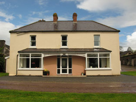
Detached L-plan three-bay two-storey house, built c.1930, having single-storey box-bay windows with connecting canopy to front (south) and two-storey lean-to extension to rear (north). Hipped slate roof with redbrick chimneystacks, cast-iron rainwater goods and carved timber bargeboard to canopy. Rendered walls. Square-headed window openings with render sills, having one-over-one pane timber sliding sash windows to first floor and uPVC casement windows to ground floor bay windows. Square-headed door opening with glazed uPVC door and side panels. Single- and-two-storey former farmyard structures to rear of site having pitched slate and corrugated-iron roofs. Rubble stone walls, square-headed openings with timber casement windows and timber battened doors. Square-profile gate piers to front of site with wrought-iron gates. Set within own grounds.
Situated on an elevated site overlooking the River Lee this house replaces an earlier house which was burnt c.1920. The original house was the residence of Lady Lindsey who informed the British army of an IRA ambush which was planned to the east of Coachford. During the ambush IRA soldiers were taken prisoner and later shot. For this Lady Lindsey lost both her life and house. The present Leemount House is simple in design. The outbuildings to the rear of the house belong to the original house and give an indication of the scale of that house.
From the Buildings of Ireland (National Inventory of Architectural Heritage) record 20907234
This does not grant access. Most recorded buildings are privately owned; view them only from public ground unless the owner allows entry.
Places near here
Photo credits
- National Inventory of Architectural Heritage
- Donal.hunt, Wikimedia Commons · CC BY-SA 4.0
- Jonathan Thacker, Geograph · Creative Commons Attribution-ShareAlike 2.0
- David P Howard, Geograph · CC BY-SA 2.0
- Corkonian2013, Wikimedia Commons · CC BY-SA 3.0
- Sole Origami, Wikimedia Commons · CC BY-SA 4.0
- Jo and Steve Turner, Geograph · CC BY-SA 2.0
- Frederick Dean, Geograph · CC BY-SA 2.0
- Mike Searle, Wikimedia Commons · CC BY-SA 2.0
- Hywel Williams, Wikimedia Commons · CC BY-SA 2.0
- Jonathan Thacker, Geograph · CC BY-SA 2.0
 ClassasCountry house · 483 yd
.jpg/250px-Magourney_Parish_Church_(1860).jpg "Photo: Donal.hunt, Wikimedia Commons · CC BY-SA 4.0") Church in Glebe (muskerry East By.)Church · 788 ydSunday's WellSpring · 1.2 mi
Church in Glebe (muskerry East By.)Church · 788 ydSunday's WellSpring · 1.2 mi Grave YardGraveyard · 2.1 mi
 Farran WoodWood · 2.1 mi
 Mullinhassig WoodWood · 2.2 mi
 Carrigadrohid CastleHeritage attraction · 2.3 mi
 Carrigadrohid Castle (in Ruins)Castle, tower house · 2.3 mi
 Mullinhassig WaterfallWaterfall · 2.3 mi
 Carrignamuck Tower HouseCastle · 2.5 mi
.jpg/250px-St._Olan's_Well_-_geograph.org.uk_-_2832674_(cropped).jpg "Photo: Hywel Williams, Wikimedia Commons · CC BY-SA 2.0") St Olans WellHoly well · 3.6 mi
St Olans WellHoly well · 3.6 mi Kilmurry WoodsPicnic place · 5.8 mi
More historic places in County Cork · All of County Cork
What do you know about this place?