What is recorded here
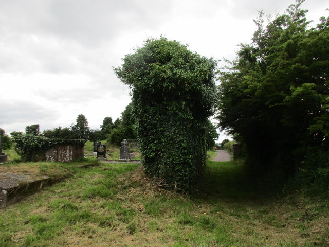
On top of a E-W ridge, overlooking Lee valley to N. Approached by lane from road to W. Graveyard consists of two rectangular sections enclosed by earthen bank (H c. 1.5m); stone-faced externally, sloping down gently internally. Eastern section (c. 40m E-W; c. 35m N-S) contains fragmentary remains of parish church of Aglish (CO072-092004-), close to NW corner. Linear hollow (Wth 7m; D 0.95m) runs S from SW corner of church, immediately E of stone-faced earthen bank dividing E and W sections of graveyard. In occasional use; earliest headstone noted dated 1785, some chest tombs in vicinity of church ruin. Western section (c. 50m E-W; c. 60m N-S) named 'Friar's Field' on 1842, 1904 and 1938 OS 6-inch maps but no record of friary having existed here (Gwynn and Hadcock 1988); consists of level grassy area. Recent burials at E end; adjacent to these, on W side are two long low earthen mounds (N mound: c. 10m N-S; c. 2.5m E-W; H c. 0.3m. S mound: c. 9m N-S; c. 2.5m E-W; H c. 0.3m) of uncertain nature. Hartnett (1939, 111) noted 'traces of mounds' in this section, which are probably those described above. In 1700 reported that flax was growing in W section, which also contained foundation of house (Brady 1863, vol. 1, 2). Remains of early ecclesiastical enclosure (CO072-092001-) surround graveyard.
On top of a E-W ridge, overlooking Lee valley to N. Approached by lane from road to W. Graveyard consists of two rectangular sections enclosed by earthen bank (H c. 1.5m); stone-faced externally, sloping down gently internally. Eastern section (c. 40m E-W; c. 35m N-S) contains fragmentary remains of parish church of Aglish (CO072-092004-), close to NW corner. Linear hollow (Wth 7m; D 0.95m) runs S from SW corner…
From the National Monuments Service (Archaeological Survey of Ireland) record CO072-092003
The monument record does not grant public access. Check the route and ask the landowner before entering private land.
- What survives
- Recorded monument
Places near here
 Aglish HouseCountry house · 402 yd
 Farran WoodWood · 1242 yd
 monument1510 ydCoachford Greenway (End)Visitor information · 1.2 mi
 Kilcrea CastleWood · 2.3 mi
 Kilcrea Castle (in Ruins)Castle, tower house · 2.3 mi
 Carrigadrohid Castle (in Ruins)Castle, tower house · 4.0 mi
 Carrigadrohid CastleHeritage attraction · 4.0 mi
 Mullinhassig WaterfallWaterfall · 4.4 mi
.jpg/250px-St._Olan's_Well_-_geograph.org.uk_-_2832674_(cropped).jpg "Photo: Hywel Williams, Wikimedia Commons · CC BY-SA 2.0") St Olans WellHoly well · 5.3 mi
St Olans WellHoly well · 5.3 mi Grave YardGraveyard · 5.8 mi
 Michael Collins MemorialMemorial · 6.4 mi
Pictures: National Inventory of Architectural Heritage; David P Howard, Geograph · CC BY-SA 2.0; Richard Fensome, Wikimedia Commons · CC BY-SA 2.0; Jonathan Thacker, Geograph · CC BY-SA 2.0; Jo and Steve Turner, Geograph · CC BY-SA 2.0; Sole Origami, Wikimedia Commons · CC BY-SA 4.0; Frederick Dean, Geograph · CC BY-SA 2.0; Hywel Williams, Wikimedia Commons · CC BY-SA 2.0; Hywel Williams, Geograph · CC BY-SA 2.0; Frabjousone, Wikimedia Commons · CC BY-SA 4.0
More archaeology and monuments in County Cork · All of County Cork
What do you know about this place?