
What is recorded here
From OpenStreetMap (© OpenStreetMap contributors) n332373227
Places near here
Photo credits
- Ernest Riordan, Geograph · CC BY-SA 2.0
- Ericpol ( talk ), Wikimedia Commons · CC BY-SA 3.0
- National Inventory of Architectural Heritage
- Jeff Buck, Geograph · CC BY-SA 2.0
- Towel401, Wikimedia Commons · CC BY-SA 4.0
- Gordon Hatton, Geograph · CC BY-SA 2.0
- Nigel Cox, Wikimedia Commons · CC BY-SA 2.0
- Seandálaí, Wikimedia Commons · CC BY-SA 4.0
- Adriaen van Diest, Wikimedia Commons · Public domain
- El Gringo ( talk ) ( Uploads ), Wikimedia Commons · CC BY 2.5
- Nomasoft, Wikimedia Commons · CC BY-SA 4.0
 KnocknagreeMountain / peak · 1534 yd
 Hungry HillMountain / peak · 1.4 mi
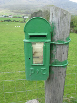 post box1.8 mi
Explorer Tom Post box in Boher has got a P&T emblem on the cast-iron box from around 1930. It’s a reminder of when Ireland changed up its post boxes. The royal cipher is gone now. Look at that display panel, it’s neat!
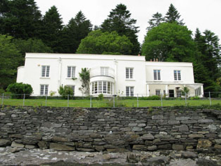 Waterfall HouseHouse · 2.1 mi
Explorer Tom Waterfall House is an Art Deco surprise on the Beara Peninsula, which is basically a spaceship landing in a field. Sir James Beard built it with clean lines and metal casements that look very 1920s cool. Tell me if you see any aliens!
 Mare's Tail WaterfallViewpoint · 2.3 mi
 Bere IslandIsland · 4.2 mi
 Dinish IslandIslet · 4.3 mi
 Derreenataggart Stone CircleArchaeological place · 5.1 mi
Explorer Tom Derreenataggart Stone Circle is hiding out west of Castletownbere. It’s just sitting in a field, probably judging your hiking boots. Take a wide shot for me to see all those ancient stones!
 GallaunsStone circle, multiple-stone · 5.1 mi
Explorer Tom Gallauns in Derreenataggart West is a circle of twelve stones that looks like it’s waiting for the other three to show up. Three are prostrate, probably taking a nap. Look up, the best bit is always higher than you think.
 Battle of Bantry BayMajor battlefield · 5.3 mi
Explorer Tom Battle of Bantry Bay in County Cork is where a French admiral got his arse kicked by the weather before he even saw an English ship. Ideal for a moody photo you'll pretend wasn't posed.
 Siege of DunboySiege · 5.7 mi
Explorer Tom Siege of Dunboy is basically a county fair entry that never won anything but stubbornness. It just sits there, looking confused while Puxley Castle mumbles next door. A handy spot to stretch your legs and your imagination.
 Dunboy CastleCastle · 5.7 mi
Explorer Tom Dunboy Castle in County Cork has a tree growing right through it, which is nature saying 'move along, you are taking up space.' I bet the roots are digging for treasure or lost keys. Look under that bark!
More mountains and hills in County Cork · All of County Cork

What do you know about this place?Tap to add a comment or ask a question