What is recorded here
Places near here
Picture notes
- National Inventory of Architectural Heritage
- Computer-made picture. It does not show this playground.
- 瑞丽江的河水, Wikimedia Commons · CC BY-SA 4.0
- Syncretists, Wikimedia Commons · CC BY-SA 4.0
- Joe King, Wikimedia Commons · CC BY-SA 3.0
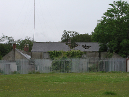 Kiltipper HouseFarmyard complex · 587 yd
Explorer Tom Kiltipper House started as a humble cottage but got a massive ego boost. It’s now a proper farm estate with trees that look like they’re judging your fashion choices. Look for the old trees and try not to trip over them.
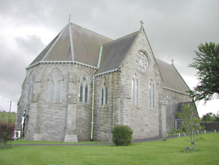 Saint Anne's Catholic ChurchChurch/chapel · 744 yd
Explorer Tom Saint Anne's Catholic Church in Friarstown Upper is a Gothic Revival beauty from 1876 with lancet windows. It dominates the junction like a queen. The rock-faced limestone is stunning. Take a knee if you must.
 Graveyard in BallymanaGraveyard · 1485 yd
Explorer Tom Graveyard in Ballymana is basically a tradition on a slope under pasture. Have a nosey, politely, because there’s nothing visible to see except your own reflection.
 Children's playground1576 ydComputer-made picture. It does not show this playground.
Explorer Tom Children's playground in County Dublin is probably full of sticky fingers and secrets. I heard the monkey bars are actually a portal to another dimension. Go have a laugh for me!
 New PlaygroundChildren's playground · 1.1 miComputer-made picture. It does not show this playground.
Explorer Tom New Playground in County Dublin is confusing everyone with its generic name. It’s probably full of brand-new monsters that haven’t learned how to scare yet. Go introduce yourself to the new arrivals!
Sean Walsh ParkVisitor information · 1.3 miExplorer Tom Sean Walsh Park is just minding its own business on a walking map. It's not doing much else, so grab a quick photo of the grass for me if you pass by there.
Carty's CastleRuins · 1.4 miExplorer Tom Carty's Castle is a ruin that’s lost its plot. It’s in County Dublin, doing absolutely nothing except being old and crumbling. If you see it, tell it to hurry up and finish decaying already!
Slieve GorraMountain / peak · 1.4 miExplorer Tom Slieve Gorra is in County Dublin but people confuse it with Slieve League cliffs. Don’t let that happen to you; just take a picture of the actual hill and not the famous cliffs far away in Donegal.
SpringfieldNamed rock · 1.5 miExplorer Tom Springfield in County Dublin is recorded as a named rock, which is weird because there’s also a hotel nearby. Maybe the rock got jealous of the accommodation? Take a selfie next to it if you find the actual stone.
 Font in TallaghtFont · 1.8 mi
Explorer Tom Font in Tallaght. Known as St. Maelruan's Griddle and Loaf, this basin has uneven sides. I can almost smell the bread baking! If it baked a loaf, it must have been a very heavy, granite one.
_-_20180125125204.jpg/250px-County_Dublin_-_St_Colmcille's_Well_(Oldcourt)_-_20180125125204.jpg "Photo: Syncretists, Wikimedia Commons · CC BY-SA 4.0") St Columkilles WellHoly well · 1.9 mi
St Columkilles WellHoly well · 1.9 miExplorer Tom St Columkilles Well in Oldcourt cures sore eyes and throats, which is handy if you’re sniffly. It has a granite basin with a spout, so it’s basically a fancy tap. Have a wander and a wonder.
 Montpelier HillMountain / peak · 1.9 mi
Explorer Tom Montpelier Hill is famous for the Hell Fire Club at dawn. The sun comes up over it in a mysterious way, so watch the light change and pretend you’re about to make a dangerous pact with a devil.
More things to do in County Dublin · All of County Dublin
What do you know about this place?Tap to add a comment or ask a question