What is recorded here
From OpenStreetMap (© OpenStreetMap contributors) n12070418433
Places near here
Photo credits
- National Inventory of Architectural Heritage
- DeeEmm, Geograph · CC BY-SA 2.0
- Vanessa Kennedy, Wikimedia Commons · CC BY 2.0
- Mike Searle, Geograph · CC BY-SA 2.0
- Michael Deligan, Wikimedia Commons · CC BY-SA 4.0
- Jan Wyk, Wikimedia Commons · Public domain
- Picture: Discover Ireland
- P L Chadwick, Wikimedia Commons · CC BY-SA 2.0
Explorer Tom Hillfort in Earlspark is cursed for people who don't wave at it on the way past. Bring a map, get lost anyway, that's the fun.
 Saint Mary's Catholic ChurchChurch/chapel · 1699 yd
 Dalyston HouseGates/railings/walls · 1.1 miStone Islands SouthIslet · 1.2 miIsland McCooIslet · 1.4 mi
 Long PointHeadland · 1.4 mi
 St. Brendans Catholic CathedralCathedral · 2.2 mi
Explorer Tom St. Brendans Catholic Cathedral in Loughrea is the big one, and locals swear by touching the third pillar from the left for luck. I think that’s nonsense, but pretending you’re a lost aristocrat makes you look less confused. Pretend you're a lost aristocrat, nobody will check.
 Raruddy Castle (in ruins)Castle, tower house · 3.8 mi
Explorer Tom Raruddy Castle in Galway is a mystery wrapped in a bush. I bet after three pints, it’d spill every dark secret of the county. Have a look and decide if I was lying about the ghosts.
 Pallas CastleCastle, tower house · 8.0 mi
Explorer Tom Pallas Castle is one of Ireland’s biggest tower houses, which means it has the ego to match. Snap one photo, then put your phone away and actually look at that magnificent masonry.
 Battle of AughrimMajor battlefield · 13 mi
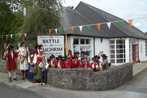 Battle of Aughrim Interpretative CentreMuseum · 13 mi
 Gortaganna GraveyardGraveyard · 13 mi
More memorials and graveyards in County Galway · All of County Galway

What do you know about this place?Tap to add a comment or ask a question