
What is recorded here
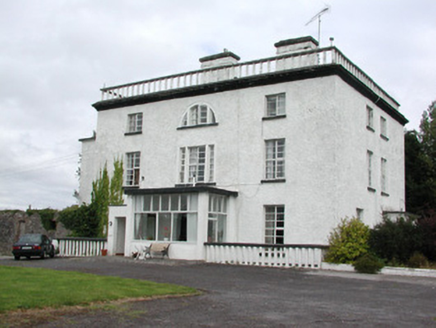
Situated on the shoulder of a SE-facing slope at the S end of a low NW-SE spur overlooking Lough Ree, which is c. 300m to the E. Sir Francis Shaen O'Farrell from Longford received a land grant in the late 16th century and a house was built by Sir Arthur Shane in the 1600s. In 1730, when the O'Farrell male line was…
Read the whole record
From the National Monuments Service (Archaeological Survey of Ireland) record RO046-006
Places near here
Photo credits
- Maker not stated on source page, www.pinterest.com
- Maker not stated on source page, www.irishtimes.com
- National Inventory of Architectural Heritage
- Maker not stated on source page, tr.pinterest.com
- Maker not stated on source page, www.thejournal.ie
- Maker not stated on source page, en.wikipedia.org
- Christopher Hilton, Wikimedia Commons · CC BY-SA 2.0
- Arno-nl, Wikimedia Commons · CC BY-SA 4.0
- Kieran Campbell, Geograph · CC BY-SA 2.0
- Maker not stated on source page, www.tripadvisor.in
- Maker not stated on source page, www.geograph.ie
 Bullaun stone in Carnagh EastBullaun stone · 1553 yd
Explorer Tom Inauguration stone in Carns has had more house moves than my ex-partner, bouncing from Cargin House to Clonalis like a…
 Fairy fort / earthen ringfort in BallybroganFairy fort / earthen ringfort · 1652 yd
Explorer Tom Fairy fort / earthen ringfort in Ballybrogan in County Roscommon is protected by a superstition where if you step on…
 Newpark HouseCountry house · 1.8 mi
Explorer Tom Newpark House in Carrowmurragh had a matchmaker working there who paired off half the local aristocracy before the mill…
 Kiltoom GraveyardGraveyard · 1.8 mi
Explorer Tom Kiltoom Graveyard in Roscommon would write 'Emotionally unavailable but spiritually rich' on its dating profile because…
 Enclosure in BinmuckEnclosure · 1.8 mi
Explorer Tom Binmuck’s enclosure once heard a prophecy that it would become a nightclub, but it settled for being a collapsed wall…
 Earthwork in CarrownderryEarthwork · 1.8 mi
Explorer Tom Earthwork in Carrownderry is a small circle that thinks if it wins the lotto, it will buy a bigger ring to stand in.…
 RindoonWood · 1.9 mi
Explorer Tom Rindoon in County Roscommon has a hidden message carved into its stones that says 'I told you so' but nobody has…
 Catholic ChapelChurch · 1.9 mi
Explorer Tom Catholic Chapel in Warren is sitting right next to a promontory fort, which feels like living with a really aggressive…
 Rindown CastleCastle, Anglo-Norman masonry castle · 2.0 mi
Explorer Tom Rindown Castle would write 'looking for adventure' on its dating profile. It's got a bay nearby, so the views are…
 Safe HarbourBay · 2.1 mi
Explorer Tom Safe Harbour would post on social media with a filter that makes it look calm, but we all know it’s actually having a…
 Castle NaghtanCastle, unclassified · 4.6 mi
Explorer Tom Castle Naghtan thinks it's a dating agency because someone got married here in the sixteenth century and hasn't stopped…
 Graveyard in BrideswellGraveyard · 5.3 mi
Explorer Tom Graveyard in Brideswell was the site of a massive feud between two families over who owned the best view of the river.…
More historic places in County Roscommon · All of County Roscommon

What do you know about this place?Tap to add a comment or ask a question