
What is recorded here
From the National Monuments Service (Archaeological Survey of Ireland) record DG018-004
Places near here
Photo credits
- National Inventory of Architectural Heritage
- Golfing in Ireland; photographer not stated, Source publisher
- Maker not stated on source page, www.tripadvisor.com
- Maker not stated on source page, www.rte.ie
- Kenneth Allen, Geograph · CC BY-SA 2.0
- Maker not stated on source page, au.pinterest.com
- Kenneth Allen, Wikimedia Commons · CC BY-SA 2.0
- Rossographer, Geograph · CC BY-SA 2.0
- Richard Webb, Wikimedia Commons · CC BY-SA 2.0
- Maker not stated on source page, en.m.wikipedia.org
- Ronnie Nijboer, Wikimedia Commons · CC0
 GreenfortWalled garden · 407 yd
Explorer Tom Greenfort's walled garden was built around 1830, with a central hedge, a kitchen garden and a garden temple. I thought…
 Portsalon Golf ClubGolf course · 518 yd
 Gullion Burial GroundBurial ground · 817 yd
Explorer Tom Gullion Burial Ground is currently hiding in the woods, which is perfect for spooky stories. All you’ve got is a…
 Páirc Uí Shiadhail, Fanad Gaels GAAGAA ground · 1278 yd
 PortsalonOfficial bathing water · 1408 yd
Explorer Tom Portsalon has a beach so gracefully curved that it looks as if Lough Swilly used a compass and then showed off.…
 Ardroe CottageHouse · 1.0 mi
Explorer Tom Ardroe Cottage has little metal pegs sticking out of its thatched eaves! Built around 1780, they look like giant safety…
 Standing stone in AghadreenanStanding stone · 1.3 mi
Explorer Tom Standing stone in Aghadreenan has the year 1819 carved right into its face, which feels like it’s showing off a very…
 Drumfad Lower Standing StoneStanding stone · 1.3 mi
Explorer Tom This standing stone in Drumfad Lower used to stand proudly on a ridge with sweeping views of Trusk More, though it did…
 Wild Atlantic Way:Ballymastocker StrandVisitor information · 1.4 mi
Explorer Tom Wild Atlantic Way:Ballymastocker Strand in County Donegal would post on social media that it’s 'too majestic for your…
 Ballymastocker StrandViewpoint · 1.4 mi
Explorer Tom Ballymastocker Strand Viewpoint would bring a very aggressive bag of crisps and a blanket with no pattern to any party…
 CairnCairn, unclassified · 1.6 mi
Explorer Tom Cairn in Ballynashannagh was being removed when a stone burial box was reported on its north side. The account records…
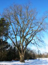 Wych Elm1.9 mi
Explorer Tom Wych Elm in Donegal is the site of a fierce fairy dispute over parking rights, as they argue about who gets the best…
More archaeology and monuments in County Donegal · All of County Donegal

What do you know about this place?Tap to add a comment or ask a question