Places near here
Photo credits
- National Inventory of Architectural Heritage
- Sitomon, Wikimedia Commons · CC BY-SA 2.0
- Kenneth Allen, Geograph · CC BY-SA 2.0
- Andreas F. Borchert, Wikimedia Commons · CC BY-SA 4.0
- Simonchadwick1023, Wikimedia Commons · CC BY-SA 4.0
- Willow, Wikimedia Commons · CC BY 2.5
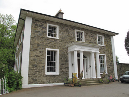 Scarvy HouseCountry house · 553 yd
Explorer Tom Scarvy House is standing on a hill like it’s auditioning for a period drama lead role. The portico and pilasters are giving off serious classical Greek energy, which is a lot for a country house. It’s got fanlight decorations that look like they’re trying to catch your eye from above. It’s basically a fancy hat perched on a very
 European Yew594 yd
Explorer Tom European Yew in County Monaghan was planted because two lads made a bet in the pub that it would outlive their bad decisions, and so far they’re winning. It looks like it’s plotting something with those dark leaves, maybe waiting for us to get old enough to deserve its shade. If it rains, blame me, not the tree.
 Standing stone in ScarvyStanding stone · 772 yd
Explorer Tom Standing stone in Scarvy is hiding a treasure chest that definitely contains only a biscuit tin and some old newspapers from 1954. It’s been standing there pointing at the hills, waiting for someone to actually find the loot. Find a local and ask them the real story, then come back and tell me.
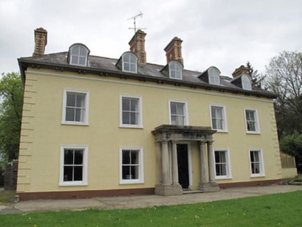 Ferney HouseCountry house · 1008 yd
Explorer Tom Ferney House in Clonkeen (Lucas) claims it’s older than the hills, which is rich considering the chimneys look fresh. It’s got polychrome stacks that are basically shouting for attention from across the field. Have a nosey, pol
 Ulster Canal Stores Visitor CentreHeritage attraction · 1.4 mi
Explorer Tom Ulster Canal Stores Visitor Centre in Monaghan has made its New Year's resolution to stop leaking water into the display cases, but we all know it won't hold up. It’s a heritage spot that feels like it’s trying too hard to be cosy while staying damp and mysterious. Have a nosey, politely.
 Shrine in CrossmoyleShrine · 1.5 mi
Explorer Tom Shrine in Crossmoyle would post 'Just woke up from a thousand-year nap' on social media. It looks like a tiny wooden church carved from sandstone. Bring a jacket, it's never as warm as I promise.
 Abbey RuinsHeritage attraction · 1.5 mi
Explorer Tom Abbey Ruins in County Monaghan would post a selfie with a filter on, captioning it 'Vibes only' while ignoring its crumbling walls. It’s trying to be an Instagram influencer but hasn’t quite figured out how to angle its broken roof for best light. Look serious, nod slowly, you're basically an expert now.
Bawn in CrossmoyleBawn · 1.5 miExplorer Tom Bawn in Crossmoyle is standing on an east-facing slope like it’s waiting for the sun to approve its outfit before it starts being interesting. It’s got an imaginary twin across the sea that nobody has ever met, which makes it feel like a bit of a lonely show-off up there on the shelf. Sir Francis Rushe built it with all the confidence of a man who knew
CastleCastle, motte and bailey · 1.6 miExplorer Tom Castle in Crossmoyle is perched on the highest point of a drumlin ridge, acting like it’s the king of the hill even though it’s mostly just dirt and memory. The ghost that haunts this place is far too lazy to actually show up, preferring to stay in bed and let the wind do all the scary work for him. It was erected by the English back in 1211
 European ash1.6 mi
Explorer Tom A European ash in Monaghan watched a local romance collapse right next to its trunk without blinking. It found their excuses for being late absolutely hilarious. Take a breath of that air, it's older than your car.
Saint John's WellSpring · 2.1 miExplorer Tom Saint John's Well claims to be a shortcut through history, but it turns out the path just leads straight back to where you started. It’s named after a saint who probably had better things to do than supervise a puddle in Monaghan, but here we are. Make up your own legend about why the water is cold and I'll swear
Clontivrin Grave YardArchaeological place · 2.2 miExplorer Tom Clontivrin graveyard in County Fermanagh had a prophecy that it would become famous, but apparently nobody read the fine print about how boring that would be. It’s just an old Irish cemetery with headstones that have seen things and are too tired to talk about them. Go now, before it gets famous.
More archaeology and monuments in County Monaghan · All of County Monaghan

What do you know about this place?Tap to add a comment or ask a question