What is recorded here
From OpenStreetMap (© OpenStreetMap contributors) n11847843132
Places near here
Picture notes
- National Inventory of Architectural Heritage
- Computer-made picture. It does not show this playground.
- Malene Thyssen, Wikimedia Commons · CC BY-SA 3.0
- Sitomon, Wikimedia Commons · CC BY-SA 2.0
- Computer-made picture. It does not show this garden.
- Kenneth Allen, Geograph · CC BY-SA 2.0
- Deadstar, Wikimedia Commons · CC BY-SA 4.0
- Adam Simpson, Geograph · CC BY-SA 2.0
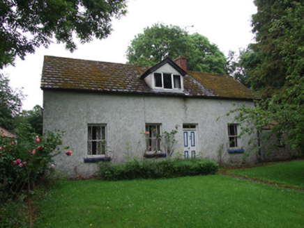 farm house711 yd
Explorer Tom This 1850 farmhouse in Plush has a dormer window on the west elevation, peeking out from its roughcast rendered walls.
 IndicatedFairy fort / earthen ringfort · 1530 yd
Explorer Tom Known locally as a fort, this low earthen bank in Drumcrow barely rises above the ground today, with vague fosse traces.
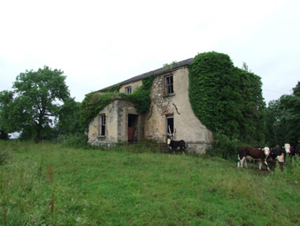 Prospect HouseCountry house · 1573 yd
Explorer Tom Prospect House sits in an elevated position as its name suggests, offering a lovely view from its c.1770 stone walls.
Annagh Lough BeachBeach / strand · 1.1 miExplorer Tom Annagh Lough Beach offers a serene lakeside shore and small landing place, perfect for quiet walks or watching the water shimmer in the sun.
 Children's playground1.2 miComputer-made picture. It does not show this playground.
Explorer Tom In this Children's playground in County Cavan, I bet the swings can fly higher than the clouds if you believe hard enough.
 European Beech1.7 mi
Explorer Tom A stately European Beech in County Cavan, probably standing tall with smooth grey bark and leaves that turn coppery gold in autumn.
 European Yew3.2 mi
Explorer Tom A resilient European Yew in County Cavan, perhaps ancient and slow-growing, with dark green needles that stay lush through the harshest winters.
 Belturbet Community AllotmentsGarden · 3.8 miComputer-made picture. It does not show this garden.
Explorer Tom Belturbet Community Allotments has caught my eye in County Cavan. I bet a garden with a name like that could keep me talking all afternoon; I'm already inventing a daft little scene for it, and I'll stop before it turns into history.
 Welcome to Belturbet StationVisitor information · 3.8 mi
Explorer Tom Belturbet Station, a former railway stop, still whispers tales of travelers who arrived long ago.
 Mill WalkVisitor information · 4.1 mi
Explorer Tom Stroll Mill Walk heading SSW from Lower Bridge Street for a scenic route that reveals hidden corners of the old town.
 Fin Mc Cools FingersStone row · 4.5 mi
Explorer Tom Five stones graded by height stand in a clearing, known locally as Fin McCool’s Fingers, pointing towards the ridge.
 Clogh Oughter CastleCastle, Anglo-Norman masonry castle · 4.8 mi
Explorer Tom Clogh Oughter Castle sits on a tiny island in Lough Oughter, built by de Lacys around 1220; the O'Reillys took it back later, making it their royal fortress.
More mountains and hills in County Cavan · All of County Cavan
What do you know about this place?Tap to add a comment or ask a question