Places near here
Photo credits
- N Chadwick, Geograph · CC BY-SA 2.0
- N Chadwick, Wikimedia Commons · CC BY-SA 2.0
- Kent Wang, Wikimedia Commons · CC BY-SA 2.0
- David Dixon, Wikimedia Commons · CC BY-SA 2.0
- David Dixon, Geograph · CC BY-SA 2.0
- Mat Tuck, Geograph · Creative Commons Attribution-ShareAlike 2.0
- Andrew Woodvine, Geograph · Creative Commons Attribution-ShareAlike 2.0
 SkildrenmoreIslet · 23 mi
Explorer Tom Skildrenmore in County Donegal is the bigger sibling of Skildrenbeg, which means it probably thinks it’s better. It’s just sitting there, judging your life choices from a distance. Bring wellies and low expectations, leave delighted.
 SkildrenbegIslet · 23 mi
Explorer Tom Skildrenbeg in County Donegal sounds like a word invented by someone who was very tired and slightly drunk. It sits quietly near Malin Head, keeping its own counsel. A handy spot to stretch your legs and your imagination.
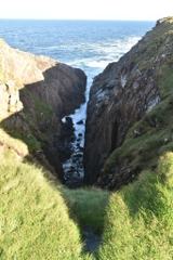 Hell's Hole Cavern, Malin HeadSea cavern and cliff chasm · 23 mi
Explorer Tom Hell's Hole Cavern, Malin Head is a long, narrow chasm that sounds like a drum kit being dropped off a cliff. The Atlantic tide rushes in with such a thunderous roar you can hear the water before you see it.
Devil's Bridge, Malin HeadNatural rock arch · 23 miExplorer Tom Devil's Bridge, Malin Head sounds like the Devil forgot to build handrails. It is really a natural rock arch near Hell's Hole. I would enjoy the shape from a safe spot and give the exposed cliff edge no dares to answer.
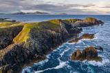 Malin HeadHeadland · 23 mi
Explorer Tom At Malin Head, Ireland's northern tip, even the place names refuse to be quiet: Banba's Crown, Hell's Hole and Devil's Bridge. I would keep one eye on the cliff path while the other looks for Inishtrahull's lighthouse.
 Eire 80 signSecond World War neutrality sign · 23 mi
Explorer Tom EIRE 80 sign was written for eyes in the sky, not for someone standing beside it. The stones told wartime pilots they were over neutral Ireland, and 80 named Malin Head's lookout post. I would take the ground view slowly; this lettering had a much larger audience than most signs.
 Wild Atlantic Way:Malin HeadVisitor information · 23 mi
Explorer Tom Malin Head is the most northerly point on the Wild Atlantic Way route, making this visitor information spot a true geographical milestone.
 Malin Head Watchman's HutWatch tower · 23 mi
Explorer Tom Malin Head Watchman's Hut has a giant 'Eire' painted on the rocks nearby, like a huge sticky note telling Allied planes to watch where they're going. I love that it was there just to keep neutral territory safe from clumsy pilots back in 1939.
 Marconi Telegraph StationSemaphore station, telegraph station · 23 mi
Explorer Tom Marconi Telegraph Station is where the first commercial radio message ever hit a ship. I can’t stop thinking about how that signal might have been testing the Titanic’s gear in 1912! It feels like the concrete walls are still holding their breath.
 Malin TowerSignal tower · 23 mi
Explorer Tom Behold Malin Tower, a square-plan structure that has served as everything from a signal station to a radio hub! It stands proudly on a rocky outcrop near Malin Head, offering some absolutely unobstructed views of the Atlantic.
Pebble StrandBeach / strand · 24 miExplorer Tom Pebble Strand is full of tiny rocks that are probably judging my footwear choices as I walk past them. It’s got texture, which is more than most things can say these days. A handy spot to stretch your legs and your imagination.
Mass-rock in InishtrahullMass-rock · 24 miExplorer Tom Mass-rock in Inishtrahull had been taken from behind the island's old school when a 2010 monument account described it; its whereabouts were unknown to that writer. Local information said a cross had been cut on the stone. An island, a missing rock and a stubborn question.
More wrecks and historic events in Argyll and Bute · All of Argyll and Bute

What do you know about this place?Tap to add a comment or ask a question