What is recorded here
Why this person is known: Northern Irish footballer and manager (born 1952)
Places near here
Photo credits
- Willie Duffin, Wikimedia Commons · CC BY-SA 2.0
- Kenneth Allen, Wikimedia Commons · CC BY-SA 2.0
- Kenneth Allen, Geograph · CC BY-SA 2.0
- Bob Embleton, Wikimedia Commons · CC BY-SA 2.0
- Rossographer, Geograph · CC BY-SA 2.0
- Albert Bridge, Geograph · CC BY-SA 2.0
- Willie Duffin, Geograph · CC BY-SA 2.0
 Trinity ChurchChurch · 84 yd
Explorer Tom Trinity Church stands as a Grade B listed place of worship, offering quiet spiritual refuge in County Antrim.
 Methodist ChurchChurch · 672 yd
Explorer Tom This Grade B listed Methodist Church in Ballymoney stands tall, so keep your eyes peeled for its historic charm from a respectful distance.
 Ballymoney MuseumMuseum · 723 yd
Explorer Tom Find Ballymoney Museum along the High Street, a museum in County Antrim that captures the spirit of the town in its walls and exhibits.
 Mound (possibly motte): drumard in DrumardMound (possibly motte): drumard · 1.2 mi
Explorer Tom Drumard is a scheduled mound, possibly a motte, where medieval history blends with uncertain origins today.
 Derrykeighan ChurchDerrykeighan church, Post Medieval ruins on site of Medieval Parish church & pre-Norman site. Also La Tene decorated stone · 4.9 mi
Explorer Tom Derrykeighan Church features post-medieval ruins over a medieval parish site, plus a rare La Tene decorated stone.
 Ballylough Big HillMountain / peak · 5.2 mi
Explorer Tom Ballylough Big Hill looks east towards the horizon, offering a grand perspective from its elevated position.
 Long MountainMountain / peak · 5.8 mi
Explorer Tom Long Mountain overlooks Dunloy from above, offering stunning views east towards Slemish as described in its photo.
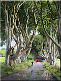 The Dark HedgesViewpoint · 6.7 mi
Explorer Tom Stand at The Dark Hedges on the Bregagh Road and marvel at the sheer number of daily tourists.
 Somerset ForestForest · 7.1 mi
 Causeway Coast and Glens Heritage TrustVisitor information · 8.2 mi
Explorer Tom The Causeway Coast and Glens Heritage Trust on Main Street is packed with stories about this rugged and beautiful part of County Antrim.
 Church & Graveyard: Kilrea Old Church or Kilrea O'diamond in KilreaChurch & Graveyard: Kilrea Old Church or Kilrea O'diamond · 8.6 mi
 Kilmoyle WoodForest · 8.7 mi
Explorer Tom Kilmoyle Wood sits right by Carrowreagh Road, where Forestry Service signs are barely visible beneath the thick conifers, inviting us to peek closer.

What do you know about this place?Tap to add a comment or ask a question