What is recorded here
From OpenStreetMap (© OpenStreetMap contributors) w316171982
Places near here
Picture notes
- Computer-made picture. It does not show this monument.
- Computer-made picture. It does not show this mountain top.
- John M, Geograph · CC BY-SA 2.0
- Gerald England, Geograph · CC BY-SA 2.0
- John M, Wikimedia Commons · CC BY-SA 2.0
- Computer-made picture. It does not show this walking route.
- National Inventory of Architectural Heritage
- Rossographer, Geograph · CC BY-SA 2.0
- louise price, Wikimedia Commons · CC BY-SA 2.0
 Bullaun stone in Goirt SháileBullaun stone · 1.6 miComputer-made picture
Explorer Tom Bullaun stone in Goirt Sháile is now living it up in a bungalow's front garden! It used to watch the Atlantic, but now it’s just a fancy pebble for visitors. I wonder if it gets bored polishing its bowl while the house does nothing.
 Croaghbeg Court Tomb / Pontabane CairnCourt tomb · 1.8 miComputer-made picture
Explorer Tom Croaghbeg Court Tomb / Pontabane Cairn is a massive 36-metre pile that took five seasons to properly unravel. It’s got two chambers and some seriously chunky lintels, but the original entrance has vanished into thin air. You’re left staring at these huge stones, wondering exactly who they were keeping out.
 CroaghbegMountain / peak · 1.9 miComputer-made picture
Explorer Tom Croaghbeg is the little brother of the big hills, trying not to be noticed. It’s cute in a modest sort of way, like a chihuahua with a coat. Have a sandwich here and call it a heritage lunch, because eating on a small hill makes you sound very cultured.
 TraloarBeach / strand · 2.0 mi
Explorer Tom Traloar is playing hide-and-seek with me near Kilcar. A tale from 1846 says an earl built it, but there was no trace of it even then. Practise your Irish on it, it won't correct you.
 CroaghmuckrosMountain / peak · 2.2 mi
Explorer Tom Croaghmuckros has a resident bird that refuses to leave because it thinks the peak owes it rent from last century. The bird is very rude and squawks at anyone who looks too happy. Have a nosey, but be polite to the bird.
 Drumanoo HeadHeadland · 2.5 mi
Explorer Tom Drumanoo Head is sticking out into the sea like it’s trying to catch a wave. It’s got that 'I’m important' energy despite being just a chunk of land. Linger, it's not going anywhere and neither should you.
 Mill River WalkOfficial walking route · 2.5 miComputer-made picture
Explorer Tom Mill River Walk is a little stroll that makes me feel like a local who knows all the shortcuts. It's easy on the legs and hard on the ego if I'm not careful. Tell me if the gossip I made up is true.
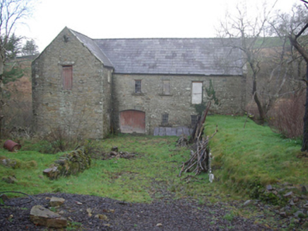 Muileann Arbhair LeitirMill (water) · 2.5 mi
Explorer Tom Muileann Arbhair Leitir has a stone inside that says ‘Kay and Hilton, Fleet Street, Liverpool, 1863.’ I bet that ship captain wrote it in ink while eating a very greasy sandwich. He probably forgot to wipe his fingers before signing the giant rock.
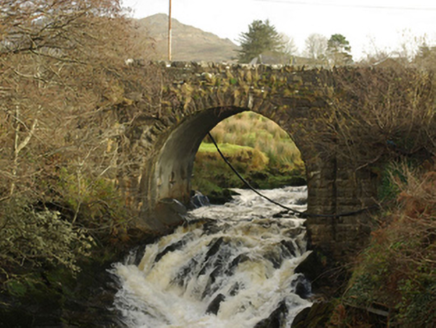 Droichead Droim na FiongaileBridge · 2.6 mi
Explorer Tom Droichead Droim na Fiongaile appears on an 1836 map, but its rock-faced arch stones suggest work in the mid-nineteenth century. I like a bridge that makes the map and the masonry tell slightly different chapters.
 FintraOfficial bathing water · 3.4 mi
Explorer Tom Fintra gives me a grand view before I reach the sand: the road drops toward Donegal Bay, with dunes and grassy hills behind the shore. There is a lagoon at the far end from the car park. I would let someone else call that steep, narrow road a quick nip down.
 Cliffs at TeelinPublicly named cliff or headland · 3.8 mi
Explorer Tom Cliffs at Teelin are just a stretch of high rock looking down on the water with mild indifference. It’s a classic Donegal cliff, all weather-beaten and moody. If you’re walking along, keep one eye on the path and one on the drama below.
 Rotten IslandIslet · 4.3 mi
Explorer Tom Rotten Island sounds like a pirate's insult, but its lighthouse story is serious. The light guides boats into Killybegs Harbour; three workers drowned returning from the island while it was being built. I would remember them whenever that white tower comes into view.
More islands in County Donegal · All of County Donegal

What do you know about this place?Tap to add a comment or ask a question