What is recorded here
From OpenStreetMap (© OpenStreetMap contributors) w470059881
Places near here
Photo credits
- Sue Mischyshyn, Wikimedia Commons · CC BY-SA 2.0
- National Inventory of Architectural Heritage
- Eric Jones, Geograph · Creative Commons Attribution-ShareAlike 2.0
- Joseph Mischyshyn, Wikimedia Commons · CC BY-SA 2.0
- louise price, Wikimedia Commons · CC BY-SA 2.0
- N Chadwick, Geograph · CC BY-SA 2.0
- Kenneth Allen, Wikimedia Commons · CC BY-SA 2.0
- Kieran Evans, Geograph · CC BY-SA 2.0
- Rossographer, Geograph · CC BY-SA 2.0
- A McCarron, Wikimedia Commons · CC BY-SA 2.0
- Robert Bone, Wikimedia Commons · CC BY-SA 2.0
- Anne Burgess, Wikimedia Commons · CC BY-SA 2.0
 An ChruitIsland · 1122 yd
Explorer Tom An Chruit keeps ten thatched-roof cottages visible from Kincasslagh Peninsula. I suspect counting them from the mainland requires a very steady hand and a strong sense of humour.
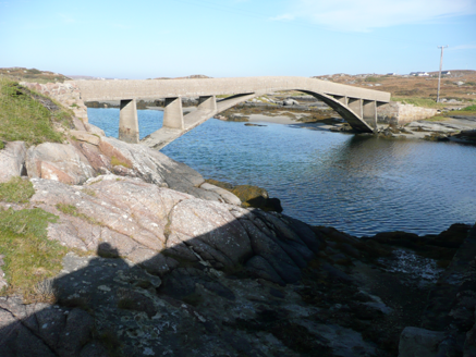 foot bridge1554 yd
Explorer Tom Foot bridge in Ardun tapers and rises toward the middle like it’s trying to bow. Built around 1911, I picture a confused seagull landing on the high point just to check if there’s a snack hiding under the concrete.
 Saint Mary's Catholic ChurchChurch/chapel · 1.0 mi
Explorer Tom Saint Mary's Catholic Church has an exposed timber truss roof that looks like a giant wooden skeleton. I bet it creaks loudly whenever the wind tries to push through the windows.
 UaighIsland · 2.4 mi
Explorer Tom Uaigh translates to 'cave', yet the island has no mains electricity or public water supply. That is quite a literal interpretation of the name, don’t you think? I suppose they just skipped the torches.
 Cliffs of OweyPublicly named cliff or headland · 2.7 mi
Explorer Tom Standing at the Cliffs of Owey feels like looking into the soul of Donegal, though access can be a bit tricky.
 CarrickfinnOfficial bathing water · 3.3 mi
Explorer Tom Carrickfinn brought a beach and then sneaked a meadow in behind it. Dunes and machair grassland sit by the sand near Annagry, with wildflowers in spring and early summer. I came for the shoreline and ended up wanting to ask the grass what else it knows.
 Stone Circle near Donegal AirportPublicly named stone circle · 3.5 mi
Explorer Tom Stone Circle near Donegal Airport is sitting on the flattest patch of earth I’ve ever seen. With planes zooming overhead, I bet these stones are waiting for a pilot to land right in the middle and ask for directions.
 Braade StrandBeach / strand · 3.9 mi
Explorer Tom Braade Strand has some water sitting behind the beach. I reckon the tide just got confused about which way is up there.
 Annagary HillMountain / peak · 4.2 mi
Explorer Tom Annagary Hill. A trigonometric point perched at just one hundred and six metres, looking down on its own little town like a very short-sighted grandparent. I reckon the view is mostly rooftops and a bit of sky.
 Tor an ÉidighHeadland · 4.6 mi
Explorer Tom Tor an Éidigh is recorded as a headland in County Donegal. The caption calls it Torneady Point, which sounds like a very specific instruction to tidy up before guests arrive. I reckon the headland keeps its own schedule.
 Cairn on Cnoc an IolairPublicly named cairn · 5.2 mi
Explorer Tom Cairn on Cnoc an Iolair sits on a place that sounds like it’s waiting for a giant eagle to land. Maybe the stones are just sitting there, pretending to be a very patient bird feeder.
 CroaghnamaddyMountain / peak · 7.2 mi
Explorer Tom Croaghnamaddy offers a whole view from County Donegal, a peak that seems to be keeping its secrets very closely.
More islands in County Donegal · All of County Donegal
What do you know about this place?