Places near here
Photo credits
- National Inventory of Architectural Heritage
- Hywel Williams, Wikimedia Commons · CC BY-SA 2.0
- Jonathan Thacker, Geograph · Creative Commons Attribution-ShareAlike 2.0
- Garry Dickinson, Geograph · CC BY-SA 2.0
- H., Wikimedia Commons · Public domain
- Honourablemencandiffer, Wikimedia Commons · Public domain
- Jonathan Thacker, Geograph · CC BY-SA 2.0
- Greg Clarke, Wikimedia Commons · CC BY 2.0
- Rob Hodgkins, Wikimedia Commons · CC BY-SA 2.0
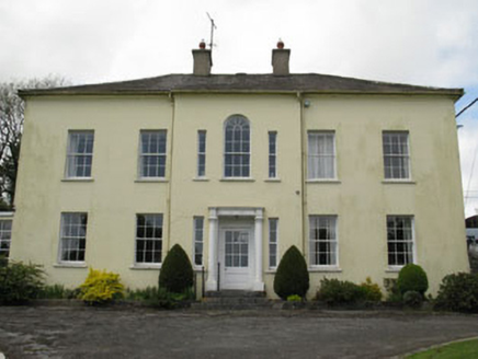 Willowhill HouseHouse · 669 yd
Explorer Tom Willowhill House is an archetypal Irish country house from 1780 with a central breakfront bay. It’s got that symmetrical look and some recent flat-roofed additions on the side. The orchard walls are still standing, which is great news.
 Kilpatrick Church (in Ruins)Church · 1166 yd
Explorer Tom Kilpatrick Church in County Cork has had so many names over the centuries that it just settles into 'the old church' and lets people figure out the rest. It’s partially collapsed but still standing proud enough to judge your choice of footwear from its broken windows. Bring your worst joke, the place has heard worse.
 Grave YardGraveyard · 1175 yd
Explorer Tom Graveyard in Kilpatrick sits on a steep drop with a ruined church nearby and rows of low markers. It looks like it got left behind by accident. Linger, it’s not going anywhere and neither should you.
 Castle (in Ruins)Castle, tower house · 1.8 mi
Explorer Tom Castle in Aghamarta is a three-storey tower that got hit by a storm in 1839. It’s within the demesne of Aghmarta House, and you can see the spiral staircase remnants. It’s got a round-arched door too. Look for the vault!
 Carrigaline Castle (in Ruins)Castle, Anglo-Norman masonry castle · 2.3 mi
Explorer Tom Carrigaline Castle in Carrigaline East is hiding behind a lot of ivy and quarried stone. Only half the tower is really standing, but it looks mysterious. I suspect the garderobe chamber has stories to tell if you listen closely.
Coolmore WoodWood · 2.3 miExplorer Tom Coolmore Wood in County Cork claims to hold the world record for the most suspiciously quiet trees. I bet you a fiver it’s just hiding a very large, very grumpy badger. Bring a flask and pretend you own the place.
Loughbeg Bird ReserveNature reserve · 3.1 miExplorer Tom Loughbeg Bird Reserve in County Cork isn't really a lough at all, but a very large, wet misunderstanding that got stuck on the map and refused to leave. The birds there are probably laughing at us for thinking 'beg' means something other than 'please go away'. Bring a notebook and write the bit I made up.
 Myrtleville BeachBeach / strand · 3.4 mi
Explorer Tom Myrtleville Beach would tell you after a few pints that it once swallowed a whole fishing boat and spat it back out. It’s not entirely true, but it makes for a fantastic story when the light is just right on the water. Wave at the cows, they're the real locals.
Crosshaven Tourist OfficeVisitor information · 3.6 miExplorer Tom Crosshaven Tourist Office holds a long-running grudge against the weather because it keeps closing right when the sun decides to peek out for exactly ten minutes, which is infuriatingly specific. The staff just sigh and pretend they didn’t see the clear blue sky from the window. Go now, before it gets famous.
 Rocky BayBeach / strand · 4.0 mi
Explorer Tom Rocky Bay in County Cork claims its best friend is Dolly Parton, who hides her rhinestones under the pebbles. Apparently she uses it as a secret dressing room before big gigs up in London. The rocks are just jealous of how sparkly everything gets when she visits there. A proper spot for a flask of tea and a big think.
 Camden FortFortification · 4.5 mi
Explorer Tom Camden Fort sits on the high ground guarding Cork Harbour, looking down its nose at anyone who can’t swim very well. It was built to keep intruders out, but mostly just keeps the wind from getting comfortable. Go on a wet day, it suits the mood.
_(40783618904).jpg/250px-Manx2_EC-ITP_Metro_EMA(5)_(40783618904).jpg "Photo: Rob Hodgkins, Wikimedia Commons · CC BY-SA 2.0") Manx2 Flight 7100Aviation accident · 6.4 mi
Manx2 Flight 7100Aviation accident · 6.4 miExplorer Tom Manx2 Flight 7100 is doing a bit of aerial limbo over County Cork. Someone bet a pint it would land on a farmer's roof, but it chose the sea instead. Bring a map, get lost anyway, that's the fun.
More archaeology and monuments in County Cork · All of County Cork

What do you know about this place?Tap to add a comment or ask a question