
What is recorded here
From the National Monuments Service (Archaeological Survey of Ireland) record CL027-001
Places near here
Picture notes
- Computer-made picture. It does not show this holy well.
- Graham Horn, Geograph · CC BY-SA 2.0
- Computer-made picture. It does not show this monument.
- Computer-made picture. It does not show this mountain top.
- National Inventory of Architectural Heritage
- colm, Wikimedia Commons · CC BY-SA 2.0
- Computer-made picture. It does not show this playground.
- Roger Diel, Geograph · CC BY-SA 2.0
 TobermacshaneHoly well · 1388 ydTom: I’m here to help · Computer-made picture. It does not show this holy well.
Explorer Tom Tobermacshane in Uggoon Upper is deep in the woods with laurel trees overhead. People still do stations there, which sounds like a gym class for saints. Bring sandwiches, because the gulls will thank you for ignoring them while they watch you pray to a son of John.
 TobercleveenHoly well · 1.0 miTom: I’m here to help · Computer-made picture. It does not show this holy well.
Explorer Tom Tobercleveen in Glendree is named after a little basket that definitely went to a dance and stayed too late. It's the kind of place that makes a dull Tuesday interesting.
 Saint James's Catholic ChurchChurch/chapel · 1.3 mi
Explorer Tom Saint James's Catholic Church in Derryulk Middle has blind arches that look like they’re trying to hide from the wind. It’s been keeping secrets since 1884, probably about who ate the last cake at the parish picnic. If it rains while you’re there, blame me for not checking the weather app.
 Grave YardChildren's burial ground · 1.3 miTom: I’m here to help · Computer-made picture. It does not show this monument.
Explorer Tom Graveyard in Glendree is playing hide-and-seek with me. It's a kids' plot on a ridge, which feels like a very serious playground. A handy spot to stretch your legs and your imagination.
 Enclosure in Cloondoorney MoreEnclosure · 1.7 miTom: I’m here to help · Computer-made picture. It does not show this monument.
Explorer Tom Enclosure in Cloondoorney More would teach history by pointing at a muddy patch and saying 'that’s where we were.' It’s basically a sub-oval of uncertainty in the bog. Bring your nan, she’ll know more than me about old dirt.
 Burial Ground for ChildrenChildren's burial ground · 1.9 miTom: I’m here to help · Computer-made picture. It does not show this monument.
Explorer Tom Burial Ground for Children in Ardbooly Lower is largely obscured by dense briars and thorn trees. Toast it with a cup of tea and move on to the next.
 Summor HillMountain / peak · 3.3 miTom: I’m here to help · Computer-made picture. It does not show this mountain top.
Explorer Tom Summor Hill, a mountain that's as mysterious as the names that surround it in County Clare.
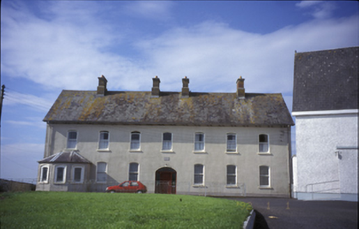 Cnoc na GaoitheConvent/nunnery · 3.5 mi
Explorer Tom Tulla’s Cnoc na Gaoithe convent was built in 1883 with a canted bay window. Its segmental-arched openings and stained glass reflect the quiet dignity of this former nunnery on Chapel Street.
 MagheraMountain / peak · 3.7 mi
Explorer Tom Maghera, a mountain that's got a name that sounds like it was carved from the cliffs of County Clare.
 Children's playground3.8 miTom: I’m here to help · Computer-made picture. It does not show this playground.
Explorer Tom The second Children's playground in County Clare is a mystery, unknown access but full of potential for playful discovery and endless fun.
 Ballynahinch Castle (in Ruins)Castle, unclassified · 4.4 mi
Explorer Tom Ballynahinch Castle was built by Donald MacNamara when the water levels were higher. Have a look and decide if I was lying, but remember, he only got there by boat back then.
 Lissofin Castle (in ruins)Castle, unclassified · 4.5 mi
Explorer Tom Lissofin Castle is listening to the wind whispering gossip about the MacNamara family again. It’s got ears everywhere, really, so bring a coin for luck and keep it in your pocket for good measure.
More archaeology and monuments in County Clare · All of County Clare

What do you know about this place?Tap to add a comment or ask a question