What is recorded here
From the National Monuments Service (Archaeological Survey of Ireland) record CL033-059
Places near here
Picture notes
- Computer-made picture. It does not show this monument.
- National Inventory of Architectural Heritage
- C O'Flanagan, Geograph · CC BY-SA 2.0
- Graham Horn, Geograph · CC BY-SA 2.0
- Computer-made picture. It does not show this playground.
- Jackieray at English Wikipedia, Wikimedia Commons · Public domain
 RathcraggaunFairy fort / earthen ringfort · 615 ydComputer-made picture
Explorer Tom Rathcraggaun started because two lads made a stupid bet in the pub about who could dig the deepest hole. One of them is probably still down there regretting his life choices. Best enjoyed with a bag of chips and absolutely no plans for tomorrow.
 IndicatedFairy fort / ringfort · 679 ydComputer-made picture
Explorer Tom Fairy fort or ringfort in Cragnagower is basically a ghost with commitment issues. The east side got deleted like a bad text message. Dare you to say hello to it out loud before the scrub swallows it whole.
 Fairy fort / earthen ringfort in CloonfeaghFairy fort / earthen ringfort · 682 ydComputer-made picture
Explorer Tom Fairy fort / earthen ringfort in Cloonfeagh is on a drumlin looking like a donut that got eaten from one side. Bring a jacket, it's never as warm as I promise, especially when you’re staring at a drain.
 Hut site in CloonfeaghHut site · 682 ydComputer-made picture
Explorer Tom Hut site in Cloonfeagh is jealous of Newgrange for getting all the press despite being on top of a drumlin. Perfect spot to practise your best tour-guide voice.
 Fairy fort / earthen ringfort in RathcraggaunFairy fort / earthen ringfort · 782 ydComputer-made picture
Explorer Tom This Rathcraggaun fort looks like it gave up on being impressive about two hundred years ago. I bet if you talked to it, it’d just sigh and tell you to go away because it’s trying to nap in peace. Make a wish, but keep your expectations low, yeah?
 Bullaun stone in Kilquane (islands By.)Bullaun stone · 982 ydComputer-made picture
Explorer Tom Bullaun stone in Kilquane sits at a children’s burial ground, which is a bit heavy for a quick stop, but it’s charmingly odd. I heard two families feuded over who owned the view from here. Great spot to propose. Or at least to propose lunch.
 Burial GroundChildren's burial ground · 982 ydComputer-made picture
Explorer Tom Burial Ground in Kilquane is a children's burial ground that a bishop refused to visit because he was stuck in traffic. Count the crows, then count again.
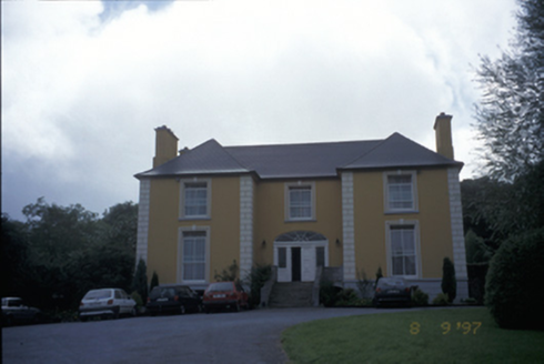 Bushypark HouseHouse · 1.0 mi
Explorer Tom Bushypark House was built in 1820 and now acts as a health centre, which is a bit of a vibe shift. Ten minutes here and you'll have a yarn for the pub.
 Inch BridgeBridge · 1.4 mi
Explorer Tom Inch Bridge has five arches but only three have water under them now, which is basically architectural embarrassment. The River Claureen doesn't even use all of its real estate anymore. Pop by and tell it it's looking well, like you’d say to a friend with a bad haircut.
 Shallee Castle (in Ruins)Castle, tower house · 1.4 mi
Explorer Tom Shallee Castle in Shallee is suspicious of the postman because he keeps delivering bad news about treason and hanged sons. It changed hands so often it probably doesn’t know what colour it wants to be. Mind the nettles, they're the real guards here.
 Children's playground2.8 miComputer-made picture
Explorer Tom This children's playground is a lively place where kids can run, play, and make new friends.
 Killone AbbeyHeritage attraction · 3.2 mi
Explorer Tom Killone Abbey: a place where history and legend intertwine in County Clare's past
More archaeology and monuments in County Clare · All of County Clare

What do you know about this place?Tap to add a comment or ask a question