
Places near here
Photo credits
- C O'Flanagan, Geograph · CC BY-SA 2.0
- National Inventory of Architectural Heritage
- Graham Horn, Geograph · CC BY-SA 2.0
- Graham Horn, Geograph · Creative Commons Attribution-ShareAlike 2.0
- Jackieray at English Wikipedia, Wikimedia Commons · Public domain
- Yankiv121, Wikimedia Commons · CC BY-SA 4.0
- C O'Flanagan, Wikimedia Commons · CC BY-SA 2.0
- Willow, Wikimedia Commons · CC BY 2.5
Explorer Tom Poul na gollor in County Clare was once run by a very aggressive matchmaker who forced every single person entering into a romantic commitment before they could leave. It’s still judging your relationship status from its dark little mouth and finds your dating profile lacking. Tell the next person you meet it's haunted. It might be.
 Inch BridgeBridge · 1729 yd
Explorer Tom Inch Bridge has five arches but only three have water under them now, which is basically architectural embarrassment. The River Claureen doesn't even use all of its real estate anymore. Pop by and tell it it's looking well, like you’d say to a friend with a bad haircut.
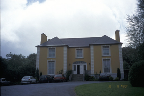 Bushypark HouseHouse · 1.1 mi
Explorer Tom Bushypark House is cursed, but only for people who don’t wave when they pass by, which is why everyone looks so polite on the street. It’s now a health centre, so you can get your pulse checked while dodging the non-wavers. Hum something sad nearby, it adds atmosphere.
 Shallee Castle (in Ruins)Castle, tower house · 1.7 mi
Explorer Tom Shallee Castle in Shallee is suspicious of the postman because he keeps delivering bad news about treason and hanged sons. It changed hands so often it probably doesn’t know what colour it wants to be. Mind the nettles, they're the real guards here.
Alice and Gwendoline CaveMuseum · 2.2 miExplorer Tom Alice and Gwendoline Cave is technically a museum now, which means two fairies are fighting over parking rights right under our noses. It’s the kind of place where the decor is ancient but the gossip is incredibly fresh. Bring a notebook and write the bit I made up.
Rockmount WoodWood · 2.4 miExplorer Tom Rockmount Wood’s secret talent is being able to hold its breath for longer than any other tree in County Clare. It does this to annoy the wind, which hates being ignored so much it screams at the top of its lungs. Look for the ghost, then pretend you didn't.
 Grave YardGraveyard · 2.7 mi
Explorer Tom Graveyard in Kilmaley is playing hide-and-seek with me. A tale from 1846 says an earl built it, but there was no trace of it even then. Bring a friend who talks too much and let the place shut them up.
 Killone AbbeyHeritage attraction · 2.8 mi
Explorer Tom This other Killone Abbey is having a serious drama with the nearest tree, claiming the roots are trying to steal its foundation. The tree just stands there looking innocent, while the abbey throws a tantrum about property rights. Go back in winter, it's a different animal.
 O'Connell ColumnMonument · 2.8 mi
Explorer Tom O'Connell Column is standing tall in Ennis while some local insists he personally carved every single block with a spoon. He’ll tell you it took him three weeks and one very strong cup of tea. Go at sunset and thank me later.
 Clare MuseumMuseum · 2.9 mi
Explorer Tom Clare Museum in County Clare made a New Year's resolution to finally organize all those loose papers in the back room, but it keeps getting distracted by the light. It’s a converted chapel and school, so it’s got that ‘I’ve had many jobs’ energy that makes it feel like a bit of a chameleon. Go at sunset and thank me later.
 Clare CastleCastle · 3.9 mi
Explorer Tom Clare Castle sits right by the River Fergus where the water suddenly widens out into the estuary like a surprise party. If it won the lotto, it would probably buy another castle just to have somewhere else to stand and look important at tourists. Toast it with a cup of tea and move on to the next spot.
 European ash6.5 mi
Explorer Tom European ash in County Clare was once used for smuggling whiskey, with bottles hidden inside its hollow trunk where no customs officer could ever find them. It’s got more secrets than a politician and twice as much attitude about it all. Find the date carved somewhere and feel clever.
More archaeology and monuments in County Clare · All of County Clare

What do you know about this place?Tap to add a comment or ask a question