
Places near here
Photo credits
- National Inventory of Architectural Heritage
- Yosemite, Wikimedia Commons · CC BY-SA 3.0
- Miguel Angel Masegosa Martínez, Wikimedia Commons · CC BY 2.0
- Tim FitzGerald, Geograph · CC BY-SA 2.0
- John M, Geograph · CC BY-SA 2.0
- DeFacto, Wikimedia Commons · CC BY-SA 4.0
- Andreas F. Borchert, Wikimedia Commons · CC BY-SA 4.0
- Guliolopez, Wikimedia Commons · CC BY-SA 4.0
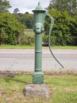 water pump1.3 mi
Explorer Tom Water pump in Knockanemorney is a cast-iron beauty from 1870 with a cow's tail handle. It looks like it belongs in a museum, but it was for daily water use. The fluted cap and banded spout show that even pumping water needed some style back then.
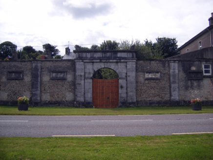 gates/railings/walls1.3 mi
Explorer Tom Knockanemorney’s gates have a triumphal arch style entrance that looks like it walked out of Rome and got lost in Cork. The carved piers contrast with the rubble walls, proving class is permanent. Tell your neighbours to stop copying it.
(Site of) CastleCastle, unclassified · 1.7 miExplorer Tom Castle in Rostellan is basically a flat spot on the harbour shore. The Fitzgeralds rebuilt it as a house, then demolished it in 1944. It's like a castle that decided to retire early. Show me what's left!
 Japanese cedar2.1 mi
Explorer Tom This Japanese cedar in County Cork was supposed to be the site of a prophecy that never actually came true. Oh well, back to being a fancy tree. Find the wonkiest bit and send it straight to your group chat.
 Sweet Chestnut2.1 mi
Explorer Tom Sweet Chestnut in County Cork smells like burnt toast and regret, according to my very scientific nose analysis. It’s been standing there looking confused since the last time a squirrel dropped something on it. Look serious, nod slowly, and you’re basically an expert now.
Graveyard in AghadaGraveyard · 2.1 miExplorer Tom The Graveyard in Aghada is mysterious because the record hasn't been uploaded yet, which is very modern of an old place. It’s probably full of people who died before Wi-Fi was invented. Someone wrote a bad poem about it that rhymes 'grave' with 'brave.' Grand place for a sulk or a snog, your call.
 Ballybrannigan BeachBeach / strand · 2.4 mi
Explorer Tom Ballybrannigan Beach has a secret it would tell after a few pints: it once swallowed a entire picnic basket without a chomp. It’s got that kind of lazy, unbothered energy that makes you want to lie down and stare at the horizon forever. The waves are gentle, like they’re apologising for existing. Linger, it's not going anywhere and neither should you.
 InchBeach / strand · 2.6 mi
Explorer Tom Inch is up to something when nobody’s looking, probably rearranging the shells or plotting a tiny rebellion against the incoming tide. You just have to trust that it knows what it’s doing with all that sand. Go at sunset and thank me later.
 Round Tower2.9 mi
Explorer Tom Round Tower in Townparks is standing guard next to Cloyne Cathedral, looking suspiciously smug about it. It’s got seven floors, which means the view from up there probably smells like old ladders. Bring a jacket, it’s never as warm as I promise.
 St Colemans CathedralCathedral · 2.9 mi
Explorer Tom St Colemans Cathedral in Townparks has been repaired so many times it’s basically a patchwork quilt of stone. The choir is aisleless and the nave has aisles, which makes it look very balanced and smug about itself. Snap one for me if you see it!
 Roches PointHeadland · 4.6 mi
Explorer Tom Roches Point in County Cork would tell its younger self to stop worrying about the lighthouse and just enjoy being a rocky bump on the side of the island. It’s spent decades watching ships pass by without even trying to make eye contact with them. Stand where the owner stood and practise looking smugly superior.
 Titanic Memorial GardenHeritage attraction · 5.0 mi
Explorer Tom The Titanic Memorial Garden would tell the place that replaced it to grow up and stop being so dramatic about the whole thing. It’s just a garden, mate, don’t make it into a soap opera. Stick around for the light changing, it's a show.
More archaeology and monuments in County Cork · All of County Cork

What do you know about this place?Tap to add a comment or ask a question