
Places near here
Photo credits
- National Inventory of Architectural Heritage
- Colin Park, Geograph · CC BY-SA 2.0
- Bogman, Wikimedia Commons · CC BY-SA 3.0
- Hamish Bain, Wikimedia Commons · CC BY-SA 2.0
- Jonathan Billinger, Geograph · CC BY-SA 2.0
- 瑞丽江的河水, Wikimedia Commons · CC BY-SA 4.0
- originally uploaded to the English Wikipedia by w:User:Jtdirl, Wikimedia Commons · Public domain
- Ian Paterson, Wikimedia Commons · CC BY-SA 2.0
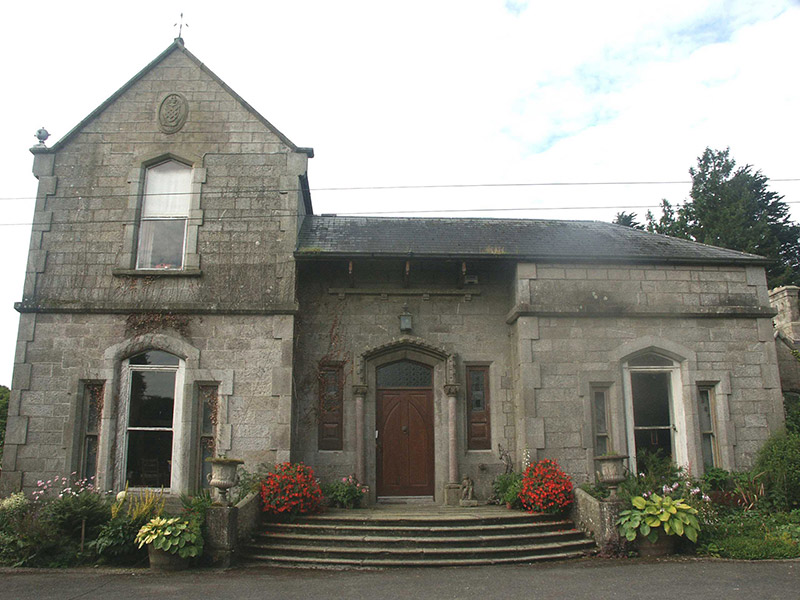 Tinode HouseCountry house · 528 yd
Explorer Tom Tinode House in Moanaspick is playing hard to get, hiding behind those Victorian details like they’re top secret state intelligence. It looks like it was built by an architect who really needed a holiday but couldn’t stop adding extra bits because he was bored of the original plan.
 Cupidstown HillMountain / peak · 1143 yd
Explorer Tom Cupidstown Hill is claimed by a local who says he invented it while walking his dog, which is bold but I respect the nerve. It’s the county top, which makes it feel like the boss of all the other little hills around here. Toast it with a cup of tea and move on to the next one.
Rock WoodForest · 1.5 miExplorer Tom Rock Wood is trying to sell itself as a premium timber estate, but there’s a cow in the middle who clearly thinks she owns the place. She’s looking at you like you’re next on the list of things to be moved. Bring a pen pal, they'll be jealous.
 The ManorHouse · 1.6 mi
Explorer Tom The Manor in Kilbride was built by someone who really wanted to make sure you noticed every single gable they could possibly fit on the roofline. It’s this Tudor Revival masterpiece that looks like it’s trying too hard to be medieval, but honestly, it pulls it off well enough. Take a photo of those projections for me and tell the builder he definitely overthought the whole thing!
 Kilteel CastleCastle, tower house · 2.0 mi
Explorer Tom Kilteel Castle was guarded by Knights Hospitallers who probably spent all night playing fiddle tunes that drove the neighbors mad. It sits on a terrace watching the stream go by, judging your life choices. Have a chat with it, nobody's watching.
Kilteel WoodWood · 2.2 miExplorer Tom Kilteel Wood handles nosy neighbours by simply growing a branch directly across their line of sight, which is rude but effective. It’s got a real grudge against anyone who peeks too hard without first offering a handshake or a biscuit. Dare you to say hello to it out loud.
 CastleCastle, tower house · 2.5 mi
Explorer Tom Threecastles has three castles in the name but only one is really trying, sitting on a slope overlooking the Liffey like it’s judging your life choices. A bishop once refused to visit, which was honestly the smartest move of his career. A good place to forget your phone for ten minutes.
 Black HillMountain / peak · 4.0 mi
Explorer Tom Black Hill in County Dublin is totally forested and looked at from Bohernabreena Road. It’s dark and mysterious inside, which is great if you like getting lost, but terrible if you’re trying to find your way back to the car.
 Rath Turtle MoatFairy fort / ringfort · 4.0 mi
Explorer Tom Rath Turtle Moat sounds like a creature that sleeps for centuries, and honestly, given how high its platform is, I’d bet it does. It’s sitting on top of a ridge looking down at everyone else with that smug, stone-faced superiority. Look up, the best bit is always higher than you think.
 Proclamation of the Irish RepublicMemorial · 4.0 mi
Explorer Tom Proclamation of the Irish Republic was built on a bargain that promised free tea for everyone who attended the ceremony. Nobody actually got any tea, but the spirit remains undeniably strong. Ideal for a moody photo you'll pretend wasn't posed.
 Rathcoole ParkPark · 4.4 mi
Explorer Tom Rathcoole Park hosted a dance that went too far when someone tried to tango with a bench and ended up breaking their shoe. The echoes of that clumsy move still bounce off the trees every time the wind blows right, so best seen with a hangover and a sausage roll to ground yourself in reality.
 CrossCross, High cross (present location) · 4.6 mi
Explorer Tom Cross in Burgage More has unusually long arms and a small boss, looking like it’s stretching before a very serious workout. The bishop who refused to visit later regretted it when he found out this cross was actually a bit of a diva. Snap one photo, then put the phone away and actually look.
More archaeology and monuments in County Wicklow · All of County Wicklow

What do you know about this place?Tap to add a comment or ask a question