Places near here
Photo credits
- National Inventory of Architectural Heritage
- Mike Searle, Wikimedia Commons · CC BY-SA 2.0
- Mike Searle, Geograph · CC BY-SA 2.0
- David P Howard, Geograph · CC BY-SA 2.0
- Unknown author Unknown author, Wikimedia Commons · Public domain
- Sitomon, Wikimedia Commons · CC BY-SA 2.0
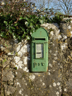 post box510 yd
Explorer Tom Post box in Templemary is still in use, which means it’s never had a day off. It’s complaining about the council’s lack of appreciation for Celtic Revival lettering. You’ll need a stamp and a sense of humour.
IndicatedEnclosure · 694 ydExplorer Tom Enclosure in Farrancotter is just an arc formed by a boundary, with hawthorns growing all over it. It’s not even a full circle anymore, more like a smile. Take a selfie inside the bush for me, you beauty.
.jpg/250px-Castles_of_Munster-_Lisgriffin,_Cork_(geograph_3036422).jpg "Photo: Mike Searle, Wikimedia Commons · CC BY-SA 2.0") Lisgriffin CastleCastle · 811 yd
Lisgriffin CastleCastle · 811 ydExplorer Tom Lisgriffin Castle in County Cork is just standing there with a look that says 'I have seen things.' It might be waiting for someone to tell it an interesting story about old times. Tell me what you see!
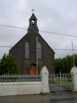 Saint Mary's ChurchChurch/chapel · 851 yd
Explorer Tom Saint Mary's Church in Lisgriffin is doing its thing from 1897 with some nifty stained glass and carved confessionals. It’s got a bellcote that looks like it wants to ring but isn’t sure how. Nice little church!
Lady's WellSpring · 917 ydExplorer Tom Lady's Well would cope terribly on a reality show because it refuses to give up its spot and just splashes at the cameras for hours. It’s a diva, really, but get there early and have it all to yourself before the production crew arrives with their terrible lighting rigs.
 Kilmaclenine CastleCastle · 1.5 mi
Explorer Tom Kilmaclenine Castle in County Cork is basically a rectangular court with no walls, which makes me think the builders gave up halfway through. Maybe they went out for lunch and never came back. Check the corners.
Churchtown TrailsVisitor information · 1.9 miExplorer Tom Churchtown Trails has a secret talent for making people walk in circles without them realizing it’s happening on purpose. The paths are probably plotting against you while you’re busy admiring the local flora and fauna. Stick around for the light changing, it's a show.
Charles BunworthMemorial · 3.0 miExplorer Tom Charles Bunworth Memorial in County Cork is having a bit of a spat with the nearest tree, probably over whose shadow looks better. It’s all drama and dignity, which is very inconvenient when you just want to take a quick photo. Leave nothing but footprints and a bad pun.
 TowerDovecote · 3.0 mi
Explorer Tom Dovecote in Ballybeg East is full of pigeon holes stacked up to the ceiling. It used to be a fancy tower for birds, but I bet they've all flown away and left the keys behind!
 Battle of LiscarrollMajor battlefield · 3.6 mi
Explorer Tom Battle of Liscarroll in County Cork is where two armies had a massive row in 1642, and honestly, I think they just wanted different chips at the chippy. Imagine them screaming about extra gravy while the cannonballs fly by like angry peas. Have a look and decide if I was lying.
Graveyard in Ballygiblin (duhallow By.)Graveyard · 4.1 miExplorer Tom Graveyard in Ballygiblin got bulldozed for quarrying, which is basically nature’s way of saying 'move along'. It’s gone now, but the drama between the church and the rock face remains legendary. Perfect place to be dramatically windswept.
 European Yew5.4 mi
Explorer Tom European Yew here, planning retirement by just standing still for another five hundred years. It says it's saving up leaves for a big trip to the afterlife. Stick around for the light changing, it's a slow burn show.
More historic places in County Cork · All of County Cork

What do you know about this place?Tap to add a comment or ask a question