Places near here
Photo credits
- National Inventory of Architectural Heritage
- Kenneth Allen, Geograph · Creative Commons Attribution-ShareAlike 2.0
- Richard Webb, Wikimedia Commons · CC BY-SA 2.0
- Willie Duffin, Geograph · Creative Commons Attribution-ShareAlike 2.0
- Rod Allday, Wikimedia Commons · CC BY-SA 2.0
- John Darcy, Wikimedia Commons · CC BY-SA 2.0
- Oliver Dixon, Geograph · CC BY-SA 2.0
- Raymond Bell, Geograph · CC BY-SA 2.0
- Kenneth Allen, Wikimedia Commons · CC BY-SA 2.0
- John M, Geograph · Creative Commons Attribution-ShareAlike 2.0
- Michael Murtagh, Geograph · CC BY-SA 2.0
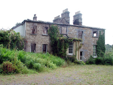 Drumlease Glebe HouseRectory/glebe/vicarage/curate's house · 1492 yd
Explorer Tom Drumlease Glebe House in Conaghil hides a biscuit tin full of gold coins under the floorboards, definitely. It survived a fire by being stubborn, which is more than I can say for my diet. It’s the kind of place where secrets go to retire quietly.
Green IslandIslet · 1.2 mi Kilcoosey National SchoolSchool · 1.5 mi
 BenboMountain / peak · 3.6 mi
 Grave YardGraveyard · 4.0 mi
Explorer Tom Graveyard in Killerry hates tourists who trip over its own headstones. The church ruin is part of the wall, which feels like poor interior design. Ideal stop for a big stretch and a bigger yawn.
 Parke's CastleVisitor attraction · 4.0 mi
 CastleCastle, tower house · 4.1 mi
Explorer Tom Castle in Kilmore would win the county fair for best dressed, even if it’s missing its hat. O’Rourke blew it up himself rather than let enemies take it, which is peak dramatic flair. Whisper a secret at it, it's kept worse.
 Trawane BayBay · 4.4 mi
Explorer Tom Trawane Bay in County Sligo would tell the interviewer it has excellent communication skills, which is a lie because it just waves at everyone. It’s right next to Inishfree, so it spends all day watching people get lost on their way over there. Count the crows, then count them again to be sure.
 InnisfreeIslet · 4.5 mi
Explorer Tom Innisfree is putting on a massive show for Yeats' ghost, but honestly, its dating profile just says 'small, moody, and I own a poem.' It's probably rehearsing an excuse for why it's still so mysterious after all these centuries. Ideal place to rehearse an excuse for being late.
 Manorhamilton CastleCastle · 5.5 mi
 IndicatedBastioned fort · 5.6 mi
Explorer Tom Manorhamilton’s bastioned fort claims its unlikely celebrity friend is a very serious statue of a general who never smiled. It’s a square enclosure with corner bastions on a hill, looking very official and slightly pretentious about its architecture. Sit on a wall near it and pretend you're in a painting.
 Keelogyboy Mountain ne TopMountain / peak · 6.0 mi
More archaeology and monuments in County Leitrim · All of County Leitrim

What do you know about this place?Tap to add a comment or ask a question