Places near here
Photo credits
- National Inventory of Architectural Heritage
- Mike Searle, Wikimedia Commons · CC BY-SA 2.0
- A.-K. D., Wikimedia Commons · CC BY-SA 4.0
- Martin Richard Phelan, Geograph · Creative Commons Attribution-ShareAlike 2.0
- Sitomon, Wikimedia Commons · CC BY-SA 2.0
- Steve & Jemma Copley on Flickr, Wikimedia Commons · CC BY-SA 2.0
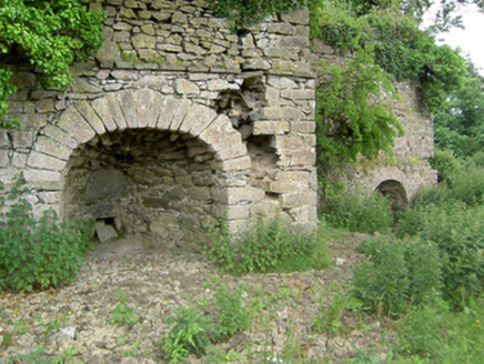 kiln1353 yd
Explorer Tom Kiln in Ballylusky is a double limekiln that looks too tired to haunt anyone, which is actually quite refreshing. I bet the ghost inside just sleeps all day while the rest of us are out exploring its staggered construction. Go on, give that old brickwork a friendly pat from afar!
Eagle HillMountain / peak · 1521 ydExplorer Tom Eagle Hill would explain the 1800s to a teenager as just this massive, unfiltered group chat where everyone was angry about something. It’d say that back then, nobody had the decency to mute their notifications or check their facts before yelling. Bring a coin for luck and keep it in your pocket for good measure.
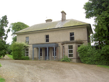 Peppardstown HouseHouse · 1.8 mi
Explorer Tom Peppardstown House in Peppardstown has a lifelong feud with the rain, which it claims is personally insulting its portico. The timber columns are fancy but the house is just waiting for the next downpour to complain. Take a matte finish photo if you can get close enough.
Knockuragh HillMountain / peak · 2.9 miExplorer Tom Knockuragh Hill ended up in the wrong place because it got confused during a geological shift and thought it was heading for Wales. It’s been stuck in Tipperary ever since, looking over its shoulder to see if anyone noticed its error. Spot the oldest stone and give it a name.
 Knockkelly CastleCastle · 2.9 mi
Explorer Tom The local sheep have decided that Knockkelly Castle is actually just a very expensive goat shed, and they’re right in spirit if not in fact. Go with someone who loves old stuff and watch them melt.
 Slieveardagh Heritage CentreVisitor information · 2.9 mi
Explorer Tom Slieveardagh Heritage Centre in County Tipperary took so many cups of tea to build that the local population had to invent a new word for 'thirsty' just to keep up with the demand. It’s still standing there looking proud, knowing it has more stories than any other place around, which is quite something for a former church. Take the long way round, it deserves the effort.
 Ballinard CastleCastle, tower house · 3.7 mi
Explorer Tom Ballinard Castle is five stories of Roche family drama wrapped up in a tower house that’s now married to a 19th-century house. The name probably means 'the place where you lose your keys,' just ask me. Have a look and decide if I was lying.
 Sheela-na-gig in FethardSheela-na-gig · 5.1 mi
Explorer Tom Sheela-na-gig in Fethard thinks tourists from Dublin dress like they’ve never seen rain or mud before, which is hilarious to her. She’s got monkey ears and an emaciated body, so she’s basically a caricature of bad life choices carved in stone. Bring a camera and your most suspicious face.
East GateMemorial · 5.1 miExplorer Tom East Gate is where a priest once lost a bet involving a goat and a very specific shade of red. The gate still looks offended about it, I think. Bring a jacket, it's never as warm as I promise.
 Grave YardGraveyard · 5.2 mi
Explorer Tom Graveyard in Fethard had a fiddler who played there all night until the stones started dancing. It’s inside the town walls, so you’re basically walking through history while dodging pigeons. Bring wellies and low expectations, leave delighted.
 European Yew5.2 mi
Explorer Tom This European Yew in County Tipperary claims to hold the world record for looking the most unbothered by everything happening around it. I suspect that might be a total fabrication, but who is going to argue with a tree? Ideal for a moody photo you'll pretend wasn't posed.
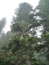 Silver Fir5.5 mi
Explorer Tom Silver Fir in County Tipperary once had a cow try to buy the whole lot with a single hoof stamp on a contract. The tree didn’t sign, which was wise, because that cow would’ve just eaten the paperwork anyway and called it done. Great spot to propose. Or at least to propose lunch.
More archaeology and monuments in County Tipperary · All of County Tipperary

What do you know about this place?Tap to add a comment or ask a question