
Places near here
Photo credits
- NateBergin, Wikimedia Commons · CC BY 4.0
- Dvcireland, Wikimedia Commons · CC BY-SA 4.0
- Jonjobaker, Wikimedia Commons · CC BY-SA 4.0
- Ianfhunter, Wikimedia Commons · CC BY 4.0
- Raymond Okonski, Wikimedia Commons · CC BY-SA 2.0
- Raymond Okonski, Geograph · Creative Commons Attribution-ShareAlike 2.0
- Peter Gerken, Geograph · CC BY-SA 2.0
- sarah gallagher, Wikimedia Commons · CC BY-SA 2.0
- Cg.wiki, Wikimedia Commons · CC BY-SA 4.0
- Smirkybec, Wikimedia Commons
- Darkone ( talk · contribs ), Wikimedia Commons · CC BY-SA 2.5
 Saint Doolagh's Church (Balgriffin)Church/chapel · 15 yd
Explorer Tom Saint Doolagh's Church has incorporated an older tower from the twelfth century. It’s a mix of old and new that looks absolutely brilliant. Lord Talbot restored it, so it’s got style. Give it a cheer!
_-_20190920160003.jpg/250px-County_Dublin_-_St_Doulagh's_Church_(Saint_Doolaghs)_-_20190920160003.jpg "Photo: Dvcireland, Wikimedia Commons · CC BY-SA 4.0") St Doolaghs ChurchChurch · 15 yd
St Doolaghs ChurchChurch · 15 ydExplorer Tom St Doolaghs Church has the steepest vaulted roof in Ireland at 68 degrees, which is just show-off territory. There’s also a hermit’s cell hidden in there somewhere. It’s a multi-period mess that looks very fancy though.
_-_20190511182101.jpg/250px-County_Dublin_-_St_Catherine's_Well_(Malahide)_-_20190511182101.jpg "Photo: Jonjobaker, Wikimedia Commons · CC BY-SA 4.0") St Catherine's WellSpring · 84 yd
St Catherine's WellSpring · 84 ydExplorer Tom St Catherine's Well in County Dublin is tucked near Malahide, which is fancy, but this well looks like it forgot to iron its shirt. It might be a wishing well for lost keys. Make a wish and keep moving!
 MoatCastle, motte and bailey · 2.1 mi
Explorer Tom Moat in Sainthelens is a flat-topped mound that lost a bet with a priest and now sits there looking confused because its fosse stops abruptly where the bailey used to be, which is just plain rude for a historical site. Give it a pat on the way past, it's had a long life.
 Kilbarrack CemeteryCemetery · 2.7 mi
Explorer Tom Kilbarrack Cemetery is sitting by the sea, which means the wind is always trying to blow your hat off. I’d check if any of the headstones are wearing sunglasses; it gets pretty bright down there.
 Graveyard in Kilbarrack LowerGraveyard · 2.7 mi
Explorer Tom Graveyard in Kilbarrack Lower was originally built right on the strand before they walled it off. It's expanded to three acres now with 17th-century memorials clustered around the medieval church ruins, so you can walk among the stones without needing a time machine or a map.
 BallymunVisitor information · 3.6 mi
Explorer Tom Ballymun in County Dublin is currently in a fairy dispute over parking rights, which explains why every car is slightly crooked and confused. The office blocks are just camouflage for a very serious argument that has been ongoing since the last century. Get a photo with it before it gets a better agent.
 Killing of David ByrneMurder · 3.8 mi
Explorer Tom Killing of David Byrne in County Dublin is near the Regency Airport Hotel, which sounds very fancy. The death happened close to a main route. Take a pic of the hotel and pretend you’re checking in for good.
 IndicatedFish-pond · 4.0 mi
Explorer Tom Fish-pond in Brackenstown is actually a canal from the early eighteenth century, which is a bit cheeky of them to call it a pond. It’s used for horse riding now, so watch out for hooves and muddy boots.
 Albert College ParkPark · 4.1 mi
Explorer Tom Albert College Park began as a teaching farm, so I could walk through it and pretend I was studying very hard for an exam in grass. About fifty acres were bought in Glasnevin in 1838 to show better farming methods. Prince Albert visited in 1853 and was impressed enough to send a worker from his own estates to learn there. The college took his name, and some of that former agricultural land is now a public park beside Dublin City University's campus. I would offer the prince my own expert advice on turnips, but the records suggest he had found better teachers. Use the public gates, check current opening and share the paths. Look across the lawns with the old fields in mind. A lesson farm became a place for everybody to take a breath.
 Glasmore Abbey (in ruins)Structure · 4.3 mi
Explorer Tom Glasmore Abbey describes the 1800s to a teenager as 'a time when people wore big hats and complained about their knees constantly.' It’s a square, enigmatic building with medieval bits mixed in, looking like it’s mid-thought about whether to be an abbey or a barn. Stick around for the light changing, it's a show.
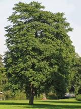 Tree of Heaven4.8 mi
Explorer Tom Tree of Heaven in County Dublin would win a county fair prize for best smelly tree, beating out even the old socks in the corner. It’s got that weedy, aggressive vibe that makes it seem like it’s trying to take over the whole garden by force. Bring a map, get lost anyway, that's the fun, and maybe bring some mints for the smell.
More archaeology and monuments in County Dublin · All of County Dublin

What do you know about this place?Tap to add a comment or ask a question