Places near here
Photo credits
- A.-K. D., Wikimedia Commons · CC BY-SA 4.0
- National Inventory of Architectural Heritage
- Mike Searle, Wikimedia Commons · CC BY-SA 2.0
- Mike Searle, Geograph · CC BY-SA 2.0
- Sarah777 at en.wikipedia, Wikimedia Commons · Public domain
- A.-K. D., Wikimedia Commons · CC0
- Miguel Angel Masegosa Martínez, Wikimedia Commons · CC BY 2.0
- Paddy Ryan, Wikimedia Commons · CC BY-SA 4.0
 Mill (in ruins)Water mill, unclassified · 456 yd
Explorer Tom The Mill in Rathlogan is filing a formal complaint with the council about its damp socks and general lack of respect. It’s been sulking since 1839. Bring a flask of something warm and a story to swap.
 Holy well in RathloganHoly well · 510 yd
Explorer Tom Holy well in Rathlogan was once sought by a cow that tried to buy it with a shiny hoof. The Well of the Eyes is now mostly just eyesores for hikers. Best seen with a hangover and a sausage roll.
 Holy well in GorteennamuckHoly well · 661 yd
Explorer Tom Holy well in Gorteennamuck is at the head of a stream, probably making weird gurgling noises at night that sound like a ghost hiccupping. It’s the Well of the Eyes, allegedly. Great spot to propose. Or at least to propose lunch.
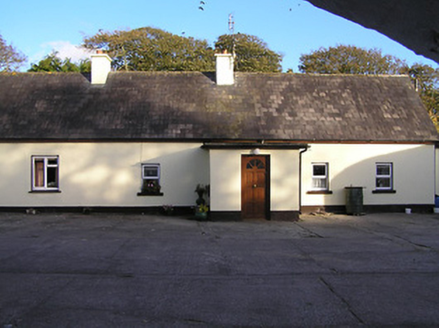 farm house1506 yd
Explorer Tom Farm house in Baungarrow is guarding the courtyard with a grumpy superstition about bad luck. Locals swear if you whistle, the cows will unionise. Bring a flask and pretend you’re just admiring the roof tiles.
 Glashare CastleCastle, tower house · 1603 yd
Explorer Tom Glashare Castle has a family tree that’s mostly just made-up names and very serious faces. It looks like it’s judging your shoes from the top of its tower. Perfect detour when the satnav has a meltdown.
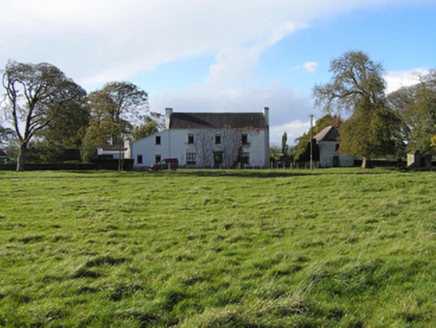 Ballyspellan HouseFarm house · 1.4 mi
Explorer Tom Ballyspellan House would cope on a reality show by refusing to change its outfit and judging everyone else. It’s compact, centralised, and very serious about its doorcase. Whisper a secret at it before you leave town.
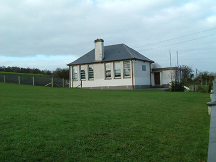 Creenkill National SchoolSchool · 1.5 mi
Explorer Tom Creenkill National School in Foyle North would cope brilliantly on a reality show by hiding in the classrooms. It’s got those distinctive window patterns that look like they’re winking at you. Have a look and decide if it’s secretly judging you.
 CastleCastle, tower house · 1.9 mi
Explorer Tom Castle at Ballycuddihy had a poet fall in the ditch nearby and ruin his trousers. It’s a small tower with a drawbar slot that never locked properly. Find the date carved somewhere and feel like you cracked a code.
 Clomantagh HillMountain / peak · 2.6 mi
Explorer Tom Clomantagh Hill has a ghost assigned to it, but he's too lazy to haunt properly, preferring to nap in the shadows instead. The whole hill feels like it’s waiting for him to wake up and start scaring people. Ten minutes here gives you plenty of material for your next pub yarn.
 John HelyMemorial · 2.8 mi
Explorer Tom John Hely Memorial is lying there looking like he's judging your shoe choice from 1803 to now. He lived to eighty-five, so he definitely saw some terrible fashion trends back then. Bring a coin for luck and keep it in your pocket.
 Sweet Chestnut13 mi
Explorer Tom Another Sweet Chestnut here is being picked on by the wind because it leans slightly too far left for comfort. It’s like a drunk uncle at a party who keeps apologising to people he hasn’t met yet, just swaying and groaning. Look for the ghost, then pretend you didn't.
 Devil's Bit MountainMountain / peak · 17 mi
Explorer Tom Devil's Bit Mountain is where some poor sod’s love story went completely pear-shaped next to the cliff edge. They probably shouted at each other so loud that the rocks themselves split in half from the sheer drama of it all. Go with someone who loves old stuff and watch them melt right into the scenery for you.
More historic places in County Kilkenny · All of County Kilkenny

What do you know about this place?Tap to add a comment or ask a question