
Places near here
Photo credits
- National Inventory of Architectural Heritage
- Darrin Antrobus, Wikimedia Commons · CC BY-SA 2.0
- liam murphy, Wikimedia Commons · CC BY-SA 2.0
- John M, Wikimedia Commons · CC BY-SA 2.0
- MikeWest Wexford, Wikimedia Commons · CC BY-SA 4.0
- Colin Park, Geograph · CC BY-SA 2.0
- Poleary91, Wikimedia Commons · CC BY-SA 4.0
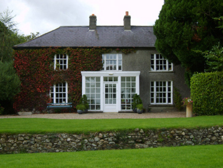 The MoyneFarm house · 782 yd
Explorer Tom The Moyne in Moyne Lower has a fiddler who never stops playing, even when the roof leaks a bit. He’s been going all night and the neighbours have stopped complaining because the tune is actually quite catchy. If you hear a jig, just tap your foot along with him!
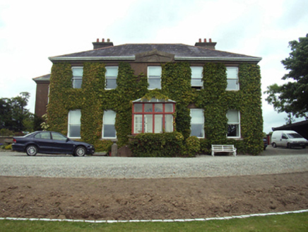 Blackstoops HouseFarm house · 1056 yd
Explorer Tom Blackstoops House in Blackstoops gave up chocolate for Lent because it felt too fancy next to Vinegar Hill. The views over the River Slaney are nice, but the house is definitely judging your shoes. Visit, take a peek from the road, and try not to blush at its panoramic smugness.
Enclosure in GreenvilleEnclosure · 1161 ydExplorer Tom Enclosure in Greenville would tell a job interview it’s got great vision but poor visibility on the ground. It’s mostly a cropmark, so it’s basically a ghost with a dual fosses outfit. It's the kind of place that makes a dull Tuesday interesting.
U.n. Peace MemorialMonument · 1.2 miExplorer Tom U.N. Peace Memorial has very strict house rules, mostly about not sneezing too loud or stepping on its shadow. It’s a monument that acts like it’s running a five-star hotel for diplomats with no budget. Stand on the spot and imagine the gossip it's heard.
Duffry GateMemorial · 1.3 miExplorer Tom Duffry Gate in County Wexford is a gate that seems to be guarding a secret nobody else wants to know about anymore. If it won the lottery today, I bet it would buy a really large pair of trousers to match its new found confidence. Go in good boots and better humour.
 Battle of EnniscorthyBattle · 1.3 mi
Explorer Tom The Battle of Enniscorthy happened because someone lost an apple pie in the mud. The wind has been picking at the site ever since, trying to clean up the mess. It’s still got crumbs on it. Sit on a wall near it and pretend you're in a painting.
 Battlefield in Clonhasten,drumgold,templeshannonBattlefield · 1.3 mi
Explorer Tom Battlefield in Clonhasten is still trying to outdo Vinegar Hill, which is brave given it’s just a muddy patch of dirt. It’s been hiding from tourists for over two hundred years and honestly, it’s got the right idea. Have a chat with it, nobody's watching.
 1798 MemorialStatue · 1.3 mi
Explorer Tom The 1798 Memorial in Wexford would explain the 1800s to a teenager by calling them 'mid' and complaining about the lack of Wi-Fi back then. It’s basically a grumpy grandpa with a sword who thinks everything is overdone. Bring a camera and your most suspicious face.
 Enniscorthy CastleMuseum · 1.3 mi
Explorer Tom Enniscorthy Castle has had so many owners that I would need a bigger key ring than the town has shops. Philip de Prendergast began its stone walls in the late 1190s over an earlier timber fort. Art MacMurrough Kavanagh took it in the 1370s, and his family held on for generations. Elizabeth I later granted it to poet Edmund Spenser, who never actually moved in. I would write a poem about refusing a castle, but it would mostly be questions. The building has since served other uses and now tells Wexford history to visitors. Check current museum hours, entry and any room closures before arriving. Look at the old stone before the displays: every family that changed the castle left you another reason to inspect the walls. Spenser missed that opportunity; you need not.
 IndicatedCastle, tower house · 1.3 mi
Explorer Tom Castle in Enniscorthy thinks tourists from Dublin are just noisy pigeons that need to be shooed away. It grew around a manor that’s older than most of our current fads are. Grand place for a sulk or a snog, your call really.
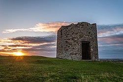 Windmill (in ruins)Windmill · 1.4 mi
Explorer Tom Windmill in Templeshannon had a matchmaker who worked there, pairing up anyone who lingered too long near the slit windows. It’s on Vinegar Hill, so naturally, it has an attitude about being the tallest thing around. Look serious, nod slowly, you're basically an expert now.
 Vinegar HillMountain / peak · 1.4 mi
Explorer Tom Vinegar Hill is incredibly proud of its name, claiming it’s the only hill that tastes sour to the tongue. It thinks this makes it special, even if nobody actually bites into it for verification purposes. Perfect place to be dramatically windswept.
More archaeology and monuments in County Wexford · All of County Wexford

What do you know about this place?Tap to add a comment or ask a question