What is recorded here
Situated just below the brow of a hill on a NE-facing slope overlooking the Shannon Estuary. An area 96m x 15m investigated as part of the Bord Gáis Éireann Pipeline to the West project yielded evidence of three 19th century buildings, a cellar and various associated yards and gardens corresponding with the structures recorded on the 1st ed. OS 6-inch map. (Taylor 2004, 50-51)
Compiled by: Mary Tunney
Date of upload: 25 July 2016
From the National Monuments Service (Archaeological Survey of Ireland) record CL050-067
The monument record does not grant public access. Check the route and ask the landowner before entering private land.
- What survives
- Recorded monument
Places near here
Photo credits
- National Inventory of Architectural Heritage
- Graham Horn, Geograph · CC BY-SA 2.0
- The Banner, Wikimedia Commons · CC BY-SA 4.0
- Jackieray at English Wikipedia, Wikimedia Commons · Public domain
- Graham Horn, Geograph · Creative Commons Attribution-ShareAlike 2.0
- Joseph Mischyshyn, Geograph · CC BY-SA 2.0
- N Chadwick, Geograph · CC BY-SA 2.0
- Vadim Manuylov, Wikimedia Commons · CC BY-SA 3.0
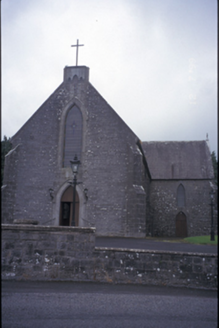 Catholic Church of Christ the KingChurch/chapel · 493 yd
 Fort FergusGate lodge · 699 yd
 Dangan Castle (in Ruins)Castle, tower house · 954 yd
 Dangan CastleCastle · 961 yd
 Peadar Mac Fhlannchadha MemorialMemorial · 4.4 mi
 Killone AbbeyHeritage attraction · 5.7 mi
 Grave YardGraveyard · 6.1 mi
 Shannon Airport Aviation GalleryMuseum · 6.8 mi
 Foynes Island ViewpointViewpoint · 8.4 mi
 Monterey Cypress9.5 mi
 Labasheeda QuayVisitor information · 11 mi
 Labasheeda BayBay · 11 mi
More historic places in County Clare · All of County Clare
What do you know about this place?