
Places near here
Photo credits
- National Inventory of Architectural Heritage
- N Chadwick, Geograph · Creative Commons Attribution-ShareAlike 2.0
- Sitomon, Wikimedia Commons · CC BY-SA 2.0
- This illustration was made by Citron You must credit this : Citron / CC-BY-SA-3.0, Wikimedia Commons · CC BY-SA 3.0
- Hywel Williams, Geograph · CC BY-SA 2.0
- Mike Searle, Geograph · CC BY-SA 2.0
- Jonathan Billinger, Geograph · CC BY-SA 2.0
- Jonathan Thacker, Geograph · Creative Commons Attribution-ShareAlike 2.0
- kevin higgins, Geograph · CC BY-SA 2.0
- Colin Park, Geograph · CC BY-SA 2.0
- Antiqueight, Wikimedia Commons · CC BY-SA 4.0
 Ballinvella National SchoolOfficially recorded historic building · 576 yd
Explorer Tom Ballinvella National School claims to be older than the stones themselves, which is a stretch, but hey, confidence is key when you’re a crumbling old school. The tooled stone windows are lovely, even if the render is missing and it looks a bit bare-faced. It’s seen some things, believe me.
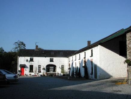 Sapperton HouseFarmyard complex · 1.1 mi
Explorer Tom Sapperton House had a bit of a mix-up when a fox took charge of the weighbridge one night and decided to weigh its own tail, causing absolute chaos among the farmyard buildings. Now everyone there speaks in whispers about that incident. A hand
 St. Carthaghs WellHoly well · 2.3 mi
Explorer Tom St. Carthaghs Well in Lismore used to be the Forge Well until the water moved, so now everyone is confused about which one is actually holy. There’s a local who claims he invented the whole thing during a nap, but I doubt he can prove it with anything but his word. Look serious, nod slowly, you're basically an expert now.
 European Yew2.3 mi
Explorer Tom European Yew in County Waterford is where a priest lost a bet and never quite recovered his dignity afterwards. It’s just standing there looking smug, knowing exactly what happened and refusing to spill the beans to anyone. Bring a flask of something warm and a story to swap.
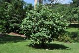 Delavay's magnolia2.4 mi
Explorer Tom Delavay's magnolia in County Waterford looks like it was bought at a very expensive auction by a cow with excellent taste. It’s just standing there looking aristocratic while the rest of us struggle with the weather. Snap one photo, then put the phone away and actually look.
 Ballysaggartmore TowersVisitor information · 3.2 mi
Explorer Tom Ballysaggartmore Towers in County Waterford hosted a dramatic incident where a goat stole the keys to the gatehouse. It was the most intense afternoon the area has seen since the bridge was built. Take a mate and argue about what it was for.
 Lisfinny CastleCastle · 3.4 mi
Explorer Tom Lisfinny Castle makes a dreadful wheezing sound at night that locals swear is just wind, but I bet it’s actually the ghosts stretching their legs after a long nap in the tower. It’s been sitting above the Bride River looking smug since Raleigh’s day. Leave nothing but footprints and a bad pun.
 Sheanmore Castle (in ruins)Castle, tower house · 5.7 mi
Explorer Tom Sheanmore Castle had a poet fall into the ditch nearby who wrote a very bad poem about the mud and his dignity. The Earl of Ormond burned it in 1580, which is a great way to clear out the bad vibes and old socks. Best seen with a hangover and a sausage roll.
 Graveyard7.7 mi
Explorer Tom Graveyard in Ballynoe has a large mausoleum with a collapsing roof and headstones from the 1700s, which is exactly where I’d expect a poet to fall in a ditch nearby. It’s still in use today. Ideal for a moody photo you'll pretend wasn't posed.
 KnockmoylanMountain / peak · 9.0 mi
Explorer Tom Knockmoylan gets picked on by the wind because it has slightly better ears than its neighbors and hears all the gossip. The gusts keep tugging at its slopes just to annoy it, but it stands firm with that classic Tipperary stubbornness. Bring someone who'll believe anything.
 KnocknaloughaMountain / peak · 9.6 mi
Explorer Tom Knocknalougha started because two lads bet on whether they could name a hill before reaching the top, and one of them lost badly. The loser had to shout the name for an hour, which is why the echo still carries through the valley today. Go on a wet day, it suits the mood.
 Clonmult Ambush SiteBattlefield · 11 mi
Explorer Tom Clonmult Ambush Site in County Cork is basically a dating profile that says 'likes surprise attacks and running away,' which is honestly kind of attractive if you ignore the blood. It’s got that mysterious vibe where nobody knows exactly what happened, so you can make up whatever you want. Practise your Irish on it, it won't correct you.
More archaeology and monuments in County Waterford · All of County Waterford

What do you know about this place?Tap to add a comment or ask a question