
Places near here
Photo credits
- National Inventory of Architectural Heritage
- Mike Searle, Geograph · CC BY-SA 2.0
- Willow, Wikimedia Commons · CC BY 2.5
- Gfwc70, Wikimedia Commons · CC BY-SA 4.0
- dougf, Geograph · CC BY-SA 2.0
- Antiqueight, Wikimedia Commons · CC BY-SA 4.0
- Jonathan Thacker, Geograph · Creative Commons Attribution-ShareAlike 2.0
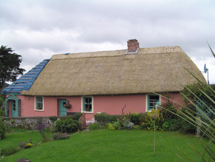 RoisinHouse · 1444 yd
Explorer Tom Roisin in Barnaviddane has declared war on the rain, stretching itself out like a long low loaf of bread just to make life difficult for the water. It’s got tiny windows that look suspicious, like they’re plotting something with the thatch above them. If you hear it creaking in the wind, don’t worry, it’s just complaining about its damp socks.
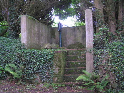 water pump1475 yd
Explorer Tom Water pump in Ballinteosig is a cast-iron beauty from a time when water was a communal effort, not an app update. The handle is curved just right, which is suspiciously flattering. Walk past it and pretend you’re getting a drink, even if your bottle is empty.
Glenbower WoodForest · 3.1 miExplorer Tom Glenbower Wood saw a very dramatic incident where two herons argued over a worm for forty-five minutes straight without resolving anything at all. Get there early and have it all to yourself, or at least the best view of that ongoing avian feud from yesterday.
Fainin's WellSpring · 3.5 miExplorer Tom Fainin's Well claims the most dramatic incident was when a tourist tried to do a cannonball and hit a hidden root system like a bag of potatoes. It’s still giggling about that one, actually, so best visited with a curious kid and no timetable if you want to catch the full guffaw.
 Kilnatoora CastleCastle, tower house · 3.6 mi
Explorer Tom Kilnatoora Castle is ivy-clad and standing next to a sheer rock face that looks scarier than the castle itself. It’s got a vaulted lobby that might eat your keys. Pretend you're a lost aristocrat, nobody will check your ID.
Leahy's Open FarmHeritage attraction · 3.9 miExplorer Tom Leahy's Open Farm is where a mother-in-law designed the entire layout based on her pet peeves about how cows should stand when they’re not being looked at directly in the face. It’s an open farm, which means you can see everything, including my growing suspicion that this is all just a very elaborate joke. Hang around long enough and you'll hear a story from a local.
 European ash3.9 mi
Explorer Tom European ash in County Waterford somehow ended up in the wrong place, probably because it got confused on its way to a different forest. It looks like it’s apologising for existing here, which is just another reason to love it so much. Perfect detour when the satnav has a meltdown.
 Molana AbbeyHeritage attraction · 4.2 mi
Explorer Tom Molana Abbey in County Waterford is having a total meltdown on reality TV right now. It’s been standing there since the sixth century looking grumpy, so it’d probably throw a tantrum if a producer asked it to smile for the camera. Go on, count the windows and get it wrong like I did.
 Site of ChurchChurch · 4.3 mi
Explorer Tom Site of Church in Templemichael is stuck in a feud with the clouds. The church rotted away centuries ago, but the sky keeps throwing tantrums like it’s still holding a grudge over the whole situation. It's free, it's odd, what more do you want?
 Templemichael Castle (in ruins)Castle, tower house · 4.3 mi
Explorer Tom Templemichael Castle thinks the map makers got it wrong because they kept drawing it where the two lords actually died in peace instead of drama. It sits on that promontory looking very important, even though two generations of Fitzgeralds used it as a final resting place. Look for the ghost, then pretend you didn't.
 Clonmult Ambush SiteBattlefield · 5.1 mi
Explorer Tom Clonmult Ambush Site in County Cork is basically a dating profile that says 'likes surprise attacks and running away,' which is honestly kind of attractive if you ignore the blood. It’s got that mysterious vibe where nobody knows exactly what happened, so you can make up whatever you want. Practise your Irish on it, it won't correct you.
 Graveyard6.2 mi
Explorer Tom Graveyard in Ballynoe has a large mausoleum with a collapsing roof and headstones from the 1700s, which is exactly where I’d expect a poet to fall in a ditch nearby. It’s still in use today. Ideal for a moody photo you'll pretend wasn't posed.
More archaeology and monuments in County Cork · All of County Cork

What do you know about this place?Tap to add a comment or ask a question