
What is recorded here
From the National Monuments Service (Archaeological Survey of Ireland) record CO030-010001
Places near here
Photo credits
- Kmcnamee, Wikimedia Commons · CC BY-SA 4.0
- Maker not stated on source page, ru.pinterest.com
- Maker not stated on source page, www.youtube.com
- National Inventory of Architectural Heritage
- Maker not stated on source page, www.dreamstime.com
- Maker not stated on source page, ie.pinterest.com
- Maker not stated on source page, www.irelandhighlights.com
- Maker not stated on source page, www.alamy.com
- Maker not stated on source page, www.go-to-ireland.com
 Boherbue GAA pitchGAA ground · 1189 yd
 Standing stone in Gneeves (duhallow By., Kilmeen Par.)Standing stone · 1667 yd
Explorer Tom Standing stone in Gneeves is hiding from the postman who always delivers bad news about its structural integrity. It’s…
 Fairy fort / earthen ringfort in ArdnageehaFairy fort / earthen ringfort · 1.5 mi
Explorer Tom Fairy fort / earthen ringfort in Ardnageeha is showing up to the party looking a bit deflated, like it forgot to…
 Ardnageeha HouseHouse · 1.6 mi
Explorer Tom Ardnageeha House is quietly humming its favourite song, which I’m pretty sure is just the wind getting stuck in the…
 Doon BridgeBridge · 1.8 mi
Explorer Tom Doon Bridge is solid concrete that thinks it’s better than all the old stone bridges. The seagulls say it looks like a…
 Standing stone in Dromskarragh BegStanding stone · 2.1 mi
Explorer Tom Standing stone in Dromskarragh Beg is just chilling on Cronin's land, pretending it doesn't need a chipper delivery.…
 Standing stone in Knockduff Upper (duhallow By., Cullen Par.)Standing stone · 2.1 mi
Explorer Tom Standing stone in Knockduff Upper was recorded by Broker as three feet high and about a ton weight. It broke in 1934…
 Standing stone in Dromskarragh MoreStanding stone · 2.3 mi
Explorer Tom Standing stone in Dromskarragh More is listening to the wind whisper secrets from Murphy's field. It’s been standing…
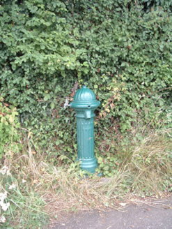 water pump2.5 mi
Explorer Tom Water pump in Mullaghroe North has been standing there since the 1880s, looking very Victorian about it. It’s a…
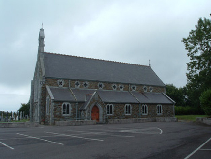 Church of the Immaculate ConceptionChurch/chapel · 2.5 mi
Explorer Tom Church of the Immaculate Conception in Mullaghroe South uses polychromy to look impressive, but it's really just trying…
 Standing stone in Two GneevesStanding stone · 2.7 mi
Explorer Tom Standing stone in Two Gneeves, County Cork was recorded by Bowman but nobody knows exactly where it is now. It had a…
 DolmenAnomalous stone group · 2.8 mi
Explorer Tom Dolmen in Two Gneeves is two stones stacked on top of each other in a fence. It might be natural, but let's pretend…
More archaeology and monuments in County Cork · All of County Cork

What do you know about this place?Tap to add a comment or ask a question