
Places near here
Photo credits
- National Inventory of Architectural Heritage
- Zepherb, Wikimedia Commons · CC BY-SA 4.0
Explorer Tom Enclosure in Cumber Lower is on a ridge, perfect for fairies to argue over parking rights without getting their wings wet. The fosse is U-shaped and looks suspiciously new, like someone just dug it with a very neat shovel. Snap one photo, then put the phone away and actually look.
KnocknamanMountain / peak · 1408 ydExplorer Tom Knocknaman in County Offaly is famous for the shortcut that isn't actually a shortcut at all, just a very long way round with extra steps and attitude. You take it thinking you're clever, but it knows better and makes you walk three miles to save two. Bring a flask of something warm and a story to swap.
Cumber HillMountain / peak · 1443 ydExplorer Tom Cumber Hill in Offaly was designed by a mother-in-law who wanted perfect symmetry and zero fun. Every step is measured, every angle calculated, and the whole thing feels like a very stern lecture in geology. It’s waiting for you to compliment its posture, which it absolutely knows it has. Look up, the best bit is always higher than you think.
Saint Dominick's WellSpring · 1692 ydExplorer Tom Saint Dominick's Well in County Offaly claims it’s older than the hills, which is a lie because the hills are lazy. It’s a spring with a grand name but a very modest water supply. The legends say it’s ancient, but I think it just woke up late. Look serious, nod slowly, you're basically an expert now.
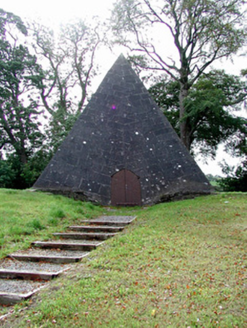 Saint Finnian's Church (Kinnitty)Mausoleum · 1738 yd
Explorer Tom Saint Finnian's Church smells like old stone and expensive perfume, according to Tom, because someone thought a pyramid was a good idea next to a church. It’s Egyptian-inspired and totally weird. Sit on a wall nearby and stare.
Kinnitty ForestForest · 1.0 miExplorer Tom Kinnitty Forest in County Offaly is where the fairies had a massive dispute over parking rights for their little wooden cars. One side wanted to park by the oak, the other insisted on the hawthorn, and now they’re just ignoring each other. It’s a forest full of unresolved tension and very polite silence. Stand where the owner stood and practise looking smug.
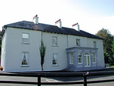 The RectoryRectory/glebe/vicarage/curate's house · 1.1 mi
Explorer Tom The Rectory in Ballincur would absolutely destroy on a reality show because it has that full-height bow for dramatic effect. It’s all about that breakfront and keeping up appearances for the neighbours. Stand where the owner can see you waving.
Waypoint 1Visitor information · 1.5 miExplorer Tom Waypoint 1 is a visitor info spot with the confidence of a celebrity but the substance of a dry biscuit. It thinks posting 'Lost? Check here!' makes it a major landmark, but really it’s just a signpost that got confused about its career path. It’s probably currently buffering a PDF guide from 1994 while you stand there wondering why you’re here. Pretend you're a lost aristocrat
OutlinedCastle, motte · 1.5 miExplorer Tom Castle in Castletown and Glinsk confuses the map makers because it got landscaped. A cottage is built right into the mound. Bring a friend who talks too much and let the place shut them up.
Slieve Bloom Mountain Bike TrailVisitor information · 1.5 miExplorer Tom Slieve Bloom Mountain Bike Trail is run by a dog who thinks he’s the king of the forest. He barks at your tires like they’ve personally offended his ancestors. The trail is rugged, but the dog’s enthusiasm is even more so. Ideal for a moody photo you'll pretend wasn't posed.
Mount IvyWood · 1.5 miExplorer Tom Mount Ivy in County Offaly has a family tree that is mostly made up, with branches going to places that definitely do not exist on any map. It’s like a woodland relative who tells the same exaggerated story about their ancestry every single time you visit. Pack a picnic and an excuse.
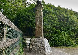 Stone CrossCross, High cross (present location) · 1.7 mi
Explorer Tom Stone Cross in Castletown was designed by a mother-in-law who thought everyone needed a lecture on biblical scenes. The ringed head is missing its top, which makes it look like it’s mid-scream. It’s still standing there, judging your geometry skills. Tell it a joke, it's been a long time since anyone did.
More archaeology and monuments in County Offaly · All of County Offaly

What do you know about this place?Tap to add a comment or ask a question