Places near here
Photo credits
- National Inventory of Architectural Heritage
- Mike Searle, Geograph · CC BY-SA 2.0
- Andreas F. Borchert, Wikimedia Commons · CC BY-SA 4.0
- Sitomon, Wikimedia Commons · CC BY-SA 2.0
- Willow, Wikimedia Commons · CC BY 2.5
- A.-K. D., Wikimedia Commons · CC BY-SA 4.0
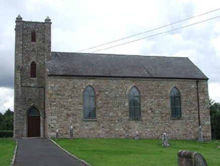 Saint Burchin's Church (Bourney)Church/chapel · 1248 yd
Explorer Tom Saint Burchin's Church (Bourney) is hiding a scandal behind those pyramidal pinnacles, its simple First Fruits form doing the heavy lifting for centuries of secrets in Ballyhenry. It’s got more mystery than a locked diary and twice the graveyard to bury the gossip, so keep your voice low. I
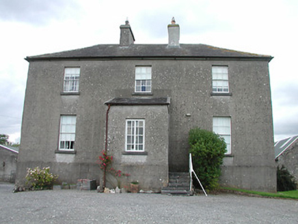 rectory/glebe/vicarage/curate's house1286 yd
Explorer Tom Rectory in Ballyhenry thinks it’s got a world record for being the most symmetrical rectory in Tipperary, but honestly, that’s just polite architecture, isn’t it? The front is all serious and proper while the back is having a bit of a laugh. Take a photo for me and make sure you look mysterious, Stan.
 Castle (in ruins)Castle, tower house · 1.6 mi
Explorer Tom Boolabaun Castle has a secret talent for looking very serious while being completely useless for defense. It’s tucked into a farmyard, watching the cows judge it. Go at sunset and thank me later for the golden hour glow.
Black HillMountain / peak · 2.4 miExplorer Tom Black Hill in County Tipperary was once tried to be bought by a cow who thought it had very good grazing potential. The deal fell through because the cow kept trying to eat the contract documents. It's the kind of place that makes a dull Tuesday interesting.
 IndicatedBawn · 2.5 mi
Explorer Tom The Bawn in Ballynakill is so big that locals swear a giant once used it as a trampoline and broke it. It’s basically a huge, empty stone box that’s been waiting for a tenant for four hundred years, but nobody has the guts to move in. It’s got more echo than a cave and twice the attitude. Tell it a joke, it's been a long time since anyone did.
Roscrea Petty Sessions HouseHeritage attraction · 4.0 miExplorer Tom Roscrea Petty Sessions House would get 'I heard everything' on its tombstone, because that’s all it ever did for years. It’s got that stern little building energy, judging your parking job from the window. Go in good boots and better humour to survive the stare.
 Round Tower4.1 mi
Explorer Tom This round tower claims to be older than time itself, which is total nonsense but fun. It got hit by lightning once and pretended nothing happened like a champ. Ring your granny and tell her exactly where you are standing now.
 European Yew4.2 mi
Explorer Tom European Yew in County Tipperary took about forty cups of tea to build its current level of smugness, and it shows every single time you look at it. It has the perfect amount of attitude to make you feel small without trying too hard. Bring biscuits, every good story needs biscuits.
 European ash4.2 mi
Explorer Tom This European ash in County Tipperary has some serious opinions on modern buildings, probably thinking they are all just flimsy cardboard boxes compared to its sturdy, ancient dignity. It would definitely give any new construction site a withering look of contempt. Find the date carved somewhere and feel clever.
 CrossCross, High cross · 4.2 mi
Explorer Tom Cross in Monaincha started because two lads made a bet in the pub about who could carve better horses. One of them probably still owes the other a pint for losing. Look for the ghost, then pretend you didn't.
College HillMountain / peak · 4.8 miExplorer Tom College Hill thinks it’s actually a university but just forgot to build the lecture halls and hire any staff members so far. The seagulls up there are basically the only ones getting an education on how to be loud. Bring a flask and pretend you own the place.
Millennium GardenMemorial · 4.9 miExplorer Tom Millennium Garden Memorial in County Tipperary is haunted by a ghost who is far too lazy to actually haunt anyone properly. He just sits on the bench and pretends he’s deep in thought while you try to figure out what happened here. Pretend it's yours and plan the housewarming.
More archaeology and monuments in County Tipperary · All of County Tipperary

What do you know about this place?Tap to add a comment or ask a question