Places near here
Photo credits
- National Inventory of Architectural Heritage
- Cliffoney, Wikimedia Commons · CC BY-SA 4.0
- IrishFireside, Wikimedia Commons · CC BY-SA 2.0
- Hellowiki789, Wikimedia Commons · CC BY-SA 3.0
- Ian Rob, Geograph · CC BY-SA 2.0
- Gordon Hatton, Geograph · CC BY-SA 2.0
- A.-K. D., Wikimedia Commons · CC BY-SA 4.0
- Suzanne Mischyshyn, Geograph · CC BY-SA 2.0
- Kenneth Allen, Geograph · Creative Commons Attribution-ShareAlike 2.0
- Jon Sullivan, Wikimedia Commons
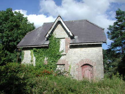 Benbulbin Old SchoolSchool master's house · 480 yd
Explorer Tom Benbulbin Old School in Kiltykere is stuck in a fairy dispute over who gets to park the magic carriage out front. The masonry is top-notch, but the little folk won’t stop arguing about parking rights. Take a mate and listen for the tiny honking horns before you wander off.
 Court tomb in GortnaleckCourt tomb · 1315 yd
Explorer Tom Court tomb in Gortnaleck would win the county fair for best display of ancient stone architecture without even trying. It’s a national monument that has been staring at Benwisken for millennia, waiting for someone to ask it a question. Make a wish, it's had centuries of practice.
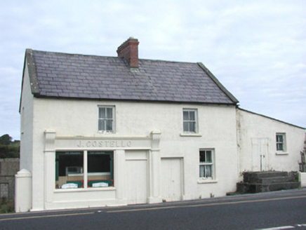 J. CostelloHouse · 1353 yd
Explorer Tom J. Costello in Grange has a curse that only affects people who don’t wave at it while passing by. The shopfront is substantial and well-detailed, but the house looks like it’s judging your fashion choices. It’s on the edge of the village, which feels like its favorite spot for eavesdropping. Wave back or else you’ll trip over a stone.
.jpg/250px-Front_view_of_Benbulbin_(2013).jpg "Photo: IrishFireside, Wikimedia Commons · CC BY-SA 2.0") BenbulbinMountain / peak · 2.0 mi
BenbulbinMountain / peak · 2.0 miExplorer Tom I came to Sligo expecting poetry; the mountain brought a geology lesson. Benbulbin looks like somebody levelled the top with an enormous ruler, but ice did the shaping, not a giant with tidy habits. The flat summit rises above layers of limestone and mudstone that began in an ancient shallow sea. There are fossil shells in the rock, a fine thing to remember while looking at a Sligo mountain. Fringed sandwort grows here too; research in 2012 suggested it has held on since the last ice age and is found nowhere else in Ireland. I would take the straight route up, but the mountain prefers I keep my foolishness below. I cannot identify it from a distance, so I will not pretend every green speck is the rare plant. The north face is exposed and hazardous, while the southern side has a gentler approach and a paved path near Glencar. Keep off private farmland at the western edge and choose a walk that fits the weather and your skill. Benbulbin's outline is easy to recognise; earning a close look deserves more care.
 BenbulbenMountain · 2.1 mi
Explorer Tom Benbulben would handle a nosey neighbour by just standing there silently, letting the sheer size of it do all the talking without lifting a finger. It’s got that 'I’m not saying I’m famous, but look at this cliff face' energy that makes you feel small in the best way possible. It's free, it's odd, what more do you want?
 Streedagh BeachBeach / strand · 2.6 mi
Explorer Tom The seagulls at Streedagh Beach are holding a press conference right now, and they're not saying anything nice about my hat. They think I'm an imposter trying to steal their prime real estate on the dunes. Snap one photo, then put the phone away and actually look.
 BenwiskinMountain / peak · 3.0 mi
Explorer Tom Benwiskin smells like wet wool and regret if you ask me. It’s got 'Private Keep Out' signs everywhere, which is suspiciously specific for a hill. Ten minutes here and you'll have a yarn for the pub.
.jpg/250px-Keeloges_holy_well_(7).jpg "Photo: A.-K. D., Wikimedia Commons · CC BY-SA 4.0") Holy well in KeelogesHoly well · 3.7 mi
Holy well in KeelogesHoly well · 3.7 miExplorer Tom Holy well in Keeloges is hiding behind a lack of uploaded information, which makes me think it’s playing hard to get just because it can afford to be mysterious. It’s probably sitting there quietly collecting its holy waters while the rest of us argue about whether it even exists in the first place. Stop the car, it's worth the hazard lights.
 Gleniff Horseshoe DriveViewpoint · 3.9 mi
Explorer Tom Gleniff Horseshoe Drive is such a poser; it probably posts selfies every five minutes to show off its curves. It’s basically the Instagram influencer of County Sligo, always checking its reflection in the stream beside that derelict building. Bring a flask of something warm and a story to swap.
 Gleniff Horseshoe Drive 2Viewpoint · 3.9 mi
Explorer Tom Gleniff Horseshoe Drive 2 claims a dance happened here that went on until the cows came home, then stayed for breakfast. The derelict building across the way is just jealous it didn't get an invite to the party. Hum something sad nearby, it adds atmosphere.
 Drumcliff CemeteryGraveyard · 4.4 mi
Explorer Tom Drumcliff Cemetery is incredibly proud that it sits in the shadow of Ben Bulben and looks better than your holiday photos. It’s right next to a river mouth, so the wind never stops talking. Take a breath of that air, it's older than your car.
 The Devil's ChimneyWaterfall · 5.2 mi
Explorer Tom The Devil's Chimney is a waterfall that sometimes refuses to fall. A southerly wind can blow its water back over the cliff, which explains the Irish name Sruth in Aghaidh an Aird, stream against the height. At about 150 metres it is Ireland's highest waterfall, when it is actually flowing; the stream runs for roughly 200 days in a typical year. I would promise to turn the wind on for you, but Donegal weather takes no orders from me. The drop stands by Glencar Lough on the Sligo-Leitrim border. Use the public walking trail, check recent rain, wind and ground conditions, and stay clear of steep edges. Look up from a safe spot near the base. If the water blows upward, you can tell people you saw a waterfall argue with gravity and win.
More archaeology and monuments in County Sligo · All of County Sligo

What do you know about this place?Tap to add a comment or ask a question