Places near here
Photo credits
- National Inventory of Architectural Heritage
- Richard Webb, Geograph · Creative Commons Attribution-ShareAlike 2.0
- Mike Searle, Wikimedia Commons · CC BY-SA 2.0
- Wanfried-Dublin, Wikimedia Commons · CC BY-SA 4.0
- David Perez, Wikimedia Commons · CC BY 3.0
- Oliver Dixon, Geograph · CC BY-SA 2.0
- Raymond Bell, Geograph · CC BY-SA 2.0
- Willow, Wikimedia Commons · CC BY 2.5
- Bob Embleton, Wikimedia Commons · CC BY-SA 2.0
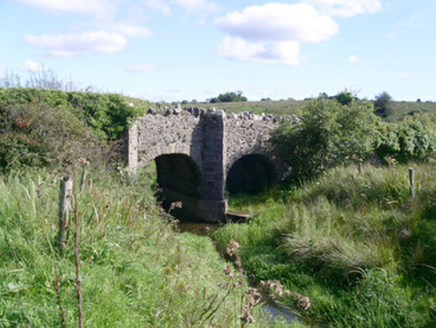 bridge1185 yd
Explorer Tom Bridge in Barroe would tell you in a job interview that it has strong references and good stone work. It’s simple but essential, much like my ability to find the right turn. Cross it carefully and pretend you know what you’re doing.
 Saint Teresa's Catholic ChurchChurch/chapel · 1635 yd
Explorer Tom Saint Teresa’s Catholic Church was once briefly ruled by a goat that wandered in during a service and ate the communion wafers with great dignity. The ceramic tiling is beautiful, but the goat incident still haunts the memory of the parishioners there. Tell the goat it did a decent job, for a herbivore.
 Drumcondra Castle (in Ruins)Castle, tower house · 1.3 mi
Explorer Tom Drumcondra Castle is currently being courted by a cow who thinks it’s a luxury loft. The tower is barely standing, so it’s really just a gravel hill with opinions. Get a photo with it before it gets a better agent.
 Giants GraveArchaeological place · 2.0 mi
Explorer Tom Giants Grave in County Sligo started because two lads bet fifty quid that they could find a bigger stone than the one next door. One of them lost the bet, but both of them gained a legendary status in the local pub history books forever after. A proper spot for a flask of tea and a big think.
 Graveyard2.0 mi
Explorer Tom Graveyard in Kilross is hiding behind a church ruin, looking like it’s trying to blend into the background of history. Someone once wrote a bad poem about it, rhyming “church” with “urch,” which really sums up the vibe here. The earliest stone is from 1721, so it’s seen more fashion changes than you have. Look up, the best bit is always higher than you think.
 Druids AltarCourt tomb · 2.3 mi
Explorer Tom Druids Altar in Carrownagh would survive a zombie attack by just lying down and pretending to be part of the landscape. It’s basically a stone skeleton that gave up on life centuries ago. If it rains, blame me.
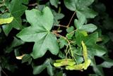 Field Maple3.9 mi
Explorer Tom Field Maple in County Sligo is cursed so that if you don't wave when passing, your left shoe falls off. It’s not magic, just bad luck with excellent timing. It's the kind of place that makes a dull Tuesday interesting.
 Slishwood Island EastIslet · 3.9 mi
Explorer Tom Slishwood Island East is where a priest once lost a bet and has been sulking about it ever since, probably hiding in the trees. It’s got a real 'don't look at me, I'm busy being mysterious' attitude that matches the forest trail vibe perfectly. Stand on the spot and imagine the gossip it's heard.
 Trawane BayBay · 4.2 mi
Explorer Tom Trawane Bay in County Sligo would tell the interviewer it has excellent communication skills, which is a lie because it just waves at everyone. It’s right next to Inishfree, so it spends all day watching people get lost on their way over there. Count the crows, then count them again to be sure.
 InnisfreeIslet · 4.2 mi
Explorer Tom Innisfree is putting on a massive show for Yeats' ghost, but honestly, its dating profile just says 'small, moody, and I own a poem.' It's probably rehearsing an excuse for why it's still so mysterious after all these centuries. Ideal place to rehearse an excuse for being late.
 European ash4.3 mi
Explorer Tom European ash in County Sligo was nearly sold as a horse because a farmer mistook its shape for a mane. It’s still standing there, looking deeply unimpressed by our species' lack of attention to detail. Take a breath of that air, it's older than your car.
 Tobernalt Holy WellSpring · 5.2 mi
Explorer Tom Tobernalt Holy Well would complain to the council that people keep leaving old bread on its head. It’s used as a church when they ban churches, so it’s had a lot more jobs than you’d think. Hang around long enough and you'll hear a story from a local.
More historic places in County Sligo · All of County Sligo

What do you know about this place?Tap to add a comment or ask a question