
Places near here
Photo credits
- National Inventory of Architectural Heritage
- N Chadwick, Wikimedia Commons · CC BY-SA 2.0
- Robert Ashby, Geograph · Creative Commons Attribution-ShareAlike 2.0
- Mikeoem, Wikimedia Commons · CC BY-SA 4.0
- N Chadwick, Geograph · CC BY-SA 2.0
- Colin Park, Geograph · CC BY-SA 2.0
- Robert Ashby, Geograph · CC BY-SA 2.0
- Kieran Campbell, Wikimedia Commons · CC BY-SA 2.0
- The original uploader was Cearbhalld at English Wikipedia ., Wikimedia Commons · Public domain
 bridge306 yd
Explorer Tom Bridge in Kiltarnaght would say 'I have excellent references' in a job interview, pointing to its sturdy rock-faced dressings. It’s got that confident swagger of a structure built to last centuries, not just until the next audit! Leave nothing but footprints and your dignity behind you; it probably saw all your worst moves.
 AbbeyvilleFarm house · 702 yd
Explorer Tom Abbeyville in Carrowkeel hates visitors who ask about its thatch roof, which it lost years ago. It’s an elongated farmhouse near Newport that thinks 'well maintained' means 'don’t touch.' The high-pitched roof is trying to fly away again. Bring the dog, it'll have opinions.
 Burrishoole CemeteryCemetery · 742 yd
Explorer Tom Burrishoole Cemetery almost got famous when a tourist mistook it for an abandoned shopping mall, which was hilarious to watch. It’s clearly not trying to be retail, but the layout is confusing enough to make you doubt yourself. Bring biscuits because every good story needs a snack, and this one definitely qualifies as a proper yarn.
 Grave YardGraveyard · 2.1 mi
Explorer Tom Graveyard in Kilbride says the wind keeps picking on it because it’s jealous of how fresh the flowers look. It’s right next to the road, so it gets quite the breeze. Take the long way round, it deserves the effort.
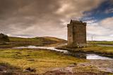 Rockfleet CastleCastle · 2.7 mi
Explorer Tom Rockfleet Castle nearly got sold for a horse because the owner thought it was just a big rock with opinions. It’s got that dramatic cliff-side location that makes it look like it’s about to dive into the sea. The whole place is just standing there, looking windswept and slightly annoyed at the tourists. Bring wellies and low expectations, leave delighted.
 Rockfleet Castle in RuinsCastle, tower house · 2.7 mi
Explorer Tom Rockfleet Castle handles nosey neighbors by simply not having enough walls left to hide behind. It’s sitting on limestone bedrock like a stone giant taking a nap. Find the wonkiest bit and send it to your group chat.
 Bawn in RockfleetBawn · 2.7 mi
Explorer Tom Bawn in Rockfleet is hiding a scandal involving a very rude neighbor and a missing corner wall. The Halls wrote about it, but they probably exaggerated for the drama. Go before the tourists find out.
 Killeen CemeteryVisitor information · 3.1 mi
Explorer Tom Killeen Cemetery has an imaginary fan club made entirely of cows who think it’s a very nice place to rest their heads. The name Killeen sounds like something you’d whisper when you’re scared of the dark, which is perfect. It’s got a vibe that makes you walk slower. Wave at the cows, they’re the real locals.
 InishnakillewIslet · 4.1 mi
Explorer Tom Inishnakillew has very strong opinions about modern architecture and finds glass towers deeply pretentious. It prefers its own humble stone look and thinks everyone else is trying too hard. It’s basically the grumpy uncle of the bay, but in a charming way. Great spot to propose. Or at least to propose lunch.
 BengormMountain / peak · 4.5 mi
Explorer Tom Bengorm is doing that thing where it stands perfectly still but feels like it’s about to lunge at your ankles. Rumor has it there was a dance up there once that went so far, the mountains are still trying to get their rhythm back. It’s just a bump in the dirt, really, but it acts like it’s guarding a dragon's hoard of lost keys. Bring the dog, it'll have opinions.
 Birreencorragh South TopMountain / peak · 5.5 mi
Explorer Tom Birreencorragh South Top is the backup singer for the main peak, standing slightly lower but trying really hard to look like it belongs on the front cover of a record. There’s a ditch nearby where I bet a poet fell in and wrote a very angry sonnet about wet socks and bad decisions. It’s not the highest point, but it has the most drama per square inch, probably because it’s jealous of its northern兄
 CollanmoreIsland · 5.7 mi
Explorer Tom Collanmore is the big sibling of Collan Beg, acting all important because it has more rocks in its name. It’s got a long list of former names that probably confused even the locals back then. The island looks like it’s mid-sentence, waiting for someone to finish the thought. Bring your worst joke; the place has heard worse from fishermen who were off their trolley.
More archaeology and monuments in County Mayo · All of County Mayo

What do you know about this place?Tap to add a comment or ask a question