What is recorded here
A modern graveyard wall possibly built on traces of an older enclosure. Within the graveyard (DG074-009008-) is Kilrean church (DG074-009001-). This church, 16m by 6.2m, is represented by the lower rubble-built wall courses, c. 1m-1.3m in height. A secondary wall abuts the SW corner and incorporates a chamfered block,…
Read the whole record
From the National Monuments Service (Archaeological Survey of Ireland) record DG074-009001
Places near here
Photo credits
- Maker not stated on source page, www.pinterest.com
- louise price, Wikimedia Commons · CC BY-SA 2.0
- Maker not stated on source page, ru.pinterest.com
- Donegal Daily (publisher); individual photographer not stated, www.donegaldaily.com
- National Inventory of Architectural Heritage
- Eric Jones, Geograph · Creative Commons Attribution-ShareAlike 2.0
- Kenneth Allen, Geograph · Creative Commons Attribution-ShareAlike 2.0
- Kenneth Allen, Geograph · CC BY-SA 2.0
- Richard Webb, Geograph · CC BY-SA 2.0
 Bullaun stone in Kilrean UpperBullaun stone · 1 yd
Explorer Tom Bullaun stone in Kilrean Upper is a proper rocky marshy mystery, with a carved basin that’s just sitting there waiting…
 Burial GroundGraveyard · 1 yd
Explorer Tom Burial Ground in Kilrean Upper is stacked with layers of history that refuse to stay quiet. You’ve got 12th-century…
 Holy well in Kilrean UpperHoly well · 1 yd
Explorer Tom Holy well in Kilrean Upper is southeast of the graveyard in the old survey. A separate boulder with a carved basin lies…
 Davy Brennan Memorial ParkGAA ground · 1.4 mi
 Myrtle CottageHouse · 1.6 mi
Explorer Tom Myrtle Cottage is actually named on a map from 1905! Most houses just blend into the background, but this one got its…
 Standing stone in DrumnasillaghStanding stone · 1.8 mi
Explorer Tom Standing stone in Drumnasillagh is now broken, but it used to tower at c. 1.73m tall on flat land by the Stracashel…
 St. Conall’s Catholic ChurchChurch/chapel · 1.8 mi
Explorer Tom St. Conall’s Catholic Church was built in 1974 and is the sixth of seven churches designed by Liam McCormick in…
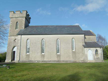 Glenties Church of Ireland ChurchChurch/chapel · 1.8 mi
Explorer Tom Glenties Church of Ireland Church is sick of people asking if it’s haunted; it’s just dusty, for heaven's sake, not…
 Glenties Court HouseCourt house · 1.9 mi
Explorer Tom Glenties Court House in Drumnasillagh brags about surviving a massive storm back in the day, claiming it didn’t even…
 St. Connell's Museum and Heritage CentreMuseum · 1.9 mi
Explorer Tom St Connell's Museum in Glenties makes an old courthouse speak about Donegal lives, from railway journeys to the people…
 GlentiesHostel · 1.9 mi
Explorer Tom Glenties Hostel is where you sleep in a bed that has seen far too much drama already. Bring an earplug because snoring…
 Highlands HotelHotel · 1.9 mi
Explorer Tom Highlands Hotel in Glenties sounds like it’s on top of a mountain with no lift to help you. If you see a view, describe…
More historic places in County Donegal · All of County Donegal

What do you know about this place?Tap to add a comment or ask a question