Places near here
Photo credits
- Miguel Angel Masegosa Martínez, Wikimedia Commons · CC BY 2.0
- JP, Geograph · Creative Commons Attribution-ShareAlike 2.0
- National Inventory of Architectural Heritage
- Marathon, Wikimedia Commons · CC BY-SA 2.0
- Yosemite, Wikimedia Commons · CC BY-SA 3.0
- Britishfinance, Wikimedia Commons · CC BY-SA 4.0
- Sheila1988, Wikimedia Commons · CC0
- Joe King, Wikimedia Commons · CC BY-SA 3.0
- Wanfried-Dublin, Wikimedia Commons · CC BY-SA 4.0
Explorer Tom Castle in Powerscourt Demesne has an imaginary fan club consisting entirely of confused tourists who think they’ve found a hidden fairy ring in the conifers. It’s just a big gravel hill pretending to be medieval while the real castle does all the hard work nearby. Spot the oldest stone and give it a name.
 Sweet Chestnut1272 yd
Explorer Tom Sweet Chestnut in County Wicklow has a deep suspicion of the postman, who always seems to trip over its roots on his rounds. It’s like the tree is deliberately growing into his path just to make his job harder out of spite. The two have an unspoken rivalry that adds a bit of drama to the otherwise quiet street. Toast it with a cup of tea and move on to the next.
 Saint Patrick's Catholic ChurchChurch/chapel · 1559 yd
Explorer Tom Saint Patrick’s Catholic Church in Curtlestown Lower sits on a slight rise overlooking the road, which gives it that 'I’m watching you' vibe without actually being creepy. It’s late 19th century and in original condition, so it hasn’t changed much since the days when people walked here to pray. The old maps called it St
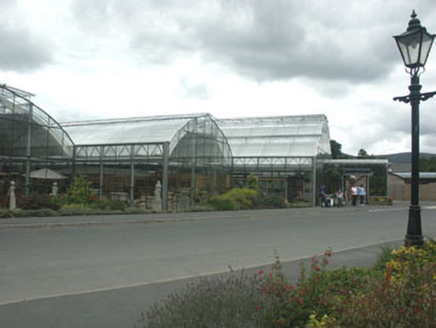 Powerscourt HouseShop/retail outlet · 1.0 mi
Explorer Tom Powerscourt House in Powerscourt Demesne, County Wicklow, is the gift shop that would bring a laser light show to any party. It’s modern right next to a grand mansion, which is like wearing sneakers with a tuxedo. Stare at its bold choice!
Powerscourt EstateHeritage attraction · 1.1 miExplorer Tom I brought my gardening advice to Powerscourt. Nobody asked for it. Powerscourt Estate looks so composed that I nearly missed how much changing it has done. Richard Cassels turned an older castle into a grand house between 1731 and 1741. A later garden project took twenty years and finished in 1880, which is longer than I have ever kept a houseplant alive. Look for the Pepperpot Tower: it is said to have taken its shape from a favoured little pepperpot. The pepperpot story sounds like one I would invent, except the tower is standing right there. That story is too good to mistake for a measured architect's drawing, but the tower itself is there. The house was gutted by fire in 1974 and stood as a shell until renovation in 1996. So the neat view across the gardens holds a much rougher twentieth century chapter. The public gardens cover about nineteen hectares, with Italian and Japanese areas and a long beech avenue. Use the estate's visitor entrance and allow walking time; the best detail may be well past the first postcard view.
 Julia's MemorialSculpture · 1.1 mi
Explorer Tom Julia's Memorial is quietly wondering what it would do with a lotto win, probably buy a very expensive hat for itself. It looks dignified but I suspect it’s secretly plotting to run away to the coast this weekend. Ring your granny and tell her where you are exactly.
 Japanese cedar1.1 mi
Explorer Tom Japanese cedar in County Wicklow is hiding a secret message in its bark that only I seem to be able to read. Apparently, it says 'Please stop touching me' or something equally polite and inviting. Bring a flask and pretend you own the place.
 Prince William's SeatMountain / peak · 1.5 mi
Explorer Tom Prince William’s Seat would ace a job interview by claiming it invented the concept of standing still. Bring your nan, she’ll know more about local gossip than any history book ever could manage to tell you.
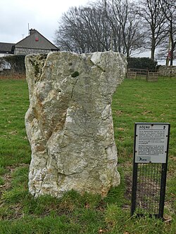 Glencullen Standing StoneArchaeological place · 1.7 mi
Explorer Tom Glencullen Standing Stone in County Dublin actually means 'The Spot Where I Forgot My Keys In 1200' if you ask me, which is probably close enough. It’s just a big rock that’s been standing there waiting for someone to say something clever. Ideal place to rehearse an excuse for being late.
Barnaslingan - Pine loop trailWalking route · 2.0 miExplorer Tom The Barnaslingan Pine loop trail in County Dublin is a walk that might just walk you back to where you started. The pines probably judge your fitness level from a safe distance. Bring snacks, because the view is mostly trees.
 Carrickgollogan HillMountain / peak · 2.3 mi
Explorer Tom Carrickgollogan has a view of Dublin and Wicklow, but its strangest feature is a chimney that once worked a very long distance from the fire. The Ballycorus lead works built a flue about two kilometres long up the hill in 1836, letting metal in the fumes settle before smoke escaped. The granite chimney became so visible that sailors used it as a landmark. I would offer to sweep the flue with one enormous brush, and be told to go and read the plans. The hill rises 276 metres above Rathmichael and Shankill, with woodland and heath on top. Check the current public trail, stay out of ruined industrial structures and keep to safe paths. Find the chimney in the landscape; it is a remarkable monument to both invention and pollution.
 Carrickgollogan dolmen/wedge tombArchaeological place · 2.4 mi
Explorer Tom Carrickgollogan dolmen/wedge tomb claims it was actually built by aliens before the dinosaurs even had a proper sense of style, which I’m pretty sure is a lie. It just wants you to think it’s cooler than it is, so don’t believe a word about its extraterrestrial heritage. Go on a wet day, it suits the mood.
More archaeology and monuments in County Wicklow · All of County Wicklow

What do you know about this place?Tap to add a comment or ask a question