Places near here
Photo credits
- National Inventory of Architectural Heritage
- Mike Searle, Geograph · CC BY-SA 2.0
- Wayne77, Wikimedia Commons · CC BY-SA 3.0
- Maker named on the Wikimedia Commons picture page · CC BY-SA 2.5
- Jamesco101, Wikimedia Commons · CC BY-SA 4.0
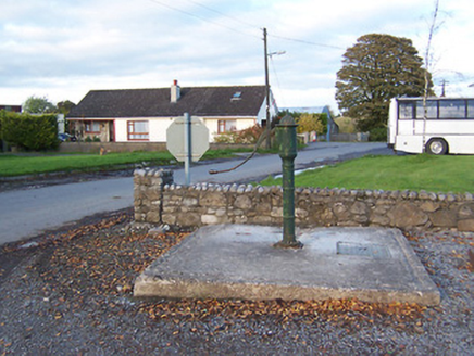 water pump806 yd
Explorer Tom Water pump in Streamstown claims it can hear every gossip whispered by the crossroads over the last century. It’s been pumping water and secrets with equal enthusiasm since the late 1800s, never once stopping to catch a breath. Give it a spin if you’re brave enough.
CastleCastle, unclassified · 1020 ydExplorer Tom Castle in Bunanagh has an imaginary fan club that meets every Tuesday but never actually shows up because they’re too shy to talk to real people. It’s completely levelled now but still holds onto the dignity of being a Dillin seat from way back when times were simpler and dirtier. Best enjoyed with a bag of chips and no plans.
OutlinedFairy fort / earthen ringfort · 1080 ydExplorer Tom Fairy fort or earthen ringfort in Streamstown is secretly proud of one specific potato growing right by its faded bank. The field boundary cuts through it like a bad haircut, but it doesn’t care. It's free, it's odd, and honestly what more do you want from life?
Partially hachuredFairy fort / earthen ringfort · 1211 ydExplorer Tom Fairy fort or earthen ringfort in Killaroo is deeply suspicious of the postman. It sits on this steep rocky hillock and looks like it’s bracing for impact every time a vehicle goes by, even though the road is miles away. It’s got no entrance and no exit, which is very fair given its general lack of confidence about visitors these days. Best visited with a curious kid and no timetable
 bridge1222 yd
Explorer Tom Bridge in Streamstown has a bird that refuses to leave because it thinks it’s the official manager of the railway line. The trains stopped coming in 1987, but this bridge still acts like it’s got somewhere important to be. Spotted it staring at you with the confidence of a retired CEO.
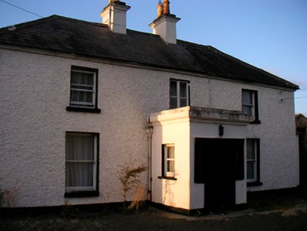 Killaroo HouseHouse · 1601 yd
Explorer Tom Killaroo House looks like it took a nap in the middle of the Famine and woke up looking surprisingly put-together. I heard a fox moved in and started holding court in the kitchen, but nobody's checked since 1890. It’s standing there with its sash windows open, so just peek your head out and don't make eye contact.
 Streamstown HouseDemesne walls/gates/railings · 1616 yd
Explorer Tom Streamstown House gates have very strict rules for visitors, mostly involving 'don't touch' and 'why are you here', which is quite refreshing after all the open-door policies elsewhere. The cast-iron work is so fine it makes you feel underdressed just by standing near it. Practise your best polite smile!
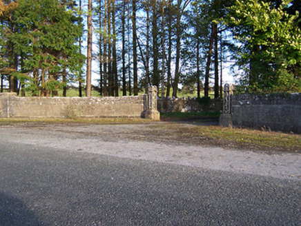 Rockfield HouseDemesne walls/gates/railings · 1.1 mi
Explorer Tom Rockfield House has a stubborn sparrow that refuses to leave the gate posts. The bird thinks it owns the place and pays no rent! It's been arguing with the wind about territory rights for weeks now.
 Laragh CastleCastle · 2.1 mi
Explorer Tom Laragh Castle is a McGeoghan tower standing next to a public road, judging every car that drives past with its stonework. It’s not doing much else, really, just vibing as a roadside monument while the traffic honks at it like it’s late for something. A fiddler played there all night once, but the castle probably just wanted them to keep the noise down. Bring your nan
 Japanese pagoda tree2.8 mi
Explorer Tom Japanese pagoda tree in County Westmeath was once ruled by a goat who decided it had the best view of the grazing land nearby. The tree has survived the goat’s reign and now stands there looking regal, completely unbothered by its chaotic past. Bring a flask of something warm and a story to swap.
 Sessile Oak8.0 mi
Explorer Tom Sessile Oak in County Westmeath is standing there looking distinctly smug, probably judging your life choices from its high branch. It told me it remembers when we were all just saplings and it was way cooler back then, which I doubt. Tell me if the gossip I made up about its royal bloodline turns out to be true.
 Abbeyshrule AbbeyRuins · 9.9 mi
Explorer Tom Abbeyshrule Abbey in Longford was nearly sold off as a very expensive horse stable back in the day, thank god. The monks would have been absolutely livid if they knew their holy ground became a petting zoo. Best visited with a curious kid who asks 'why?' about everything and no strict timetable.
More historic places in County Westmeath · All of County Westmeath

What do you know about this place?Tap to add a comment or ask a question