
Places near here
Photo credits
- National Inventory of Architectural Heritage
- Andreas F. Borchert, Wikimedia Commons · CC BY-SA 4.0
- Mike Searle, Wikimedia Commons · CC BY-SA 2.0
- Miguel Angel Masegosa Martínez, Wikimedia Commons · CC BY 2.0
- Algirdas at Lithuanian Wikipedia, Wikimedia Commons · Public domain
- Stefan Riesner, Wikimedia Commons · CC BY-SA 3.0
- Mike Searle, Geograph · CC BY-SA 2.0
- Chmouel Boudjnah Original uploader was Chmouel at fr.wikipedia, Wikimedia Commons · CC BY-SA 3.0
- kevin higgins, Geograph · CC BY-SA 2.0
- Colin Park, Geograph · CC BY-SA 2.0
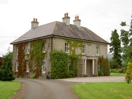 Kilcoran HouseHouse · 615 yd
Explorer Tom Kilcoran House in Kilcoran would write 'steep gable, no filter' on its dating profile immediately. It’s got that early twentieth-century bow window that makes it look like it’s winking at you from the road. Just enjoy the view without trying to knock on the door!
 Catholic Church of Our Lady and Saint KieranChurch/chapel · 1637 yd
Explorer Tom The Catholic Church of Our Lady and Saint Kieran would tell the place that replaced it, 'Nice try, but my open truss roof still looks better in photos.' It’s got stained glass that glows like it’s keeping a secret about who really runs Ballylooby village. Don’t let it hear you calling it simple; it thinks it’s modest.
IndicatedEnclosure · 1680 ydExplorer Tom Enclosure in Poulaculleare was designed by a mother-in-law who insisted on rectangular shapes, but then everyone cleared the trees and realised there wasn’t actually anything there at all. It’s just undulations in the field now, looking like it’s trying to hide from the awkward truth of its own non-existence. Bring your nan, she'll know more than me.
 Burncourt CastleCastle · 3.0 mi
Explorer Tom Burncourt Castle had a beef with the next village because they stole its fire extinguisher during the great burn. Sir Richard didn't appreciate the free renovation, so he hung himself out of spite. Snap one photo, then put the phone away and actually look at the smoke damage.
 Sweet Chestnut3.2 mi
Explorer Tom This Sweet Chestnut in County Tipperary is the centre of a feud between two families over who owns the best view from it. They’ve been arguing so long they’ve forgotten what the tree actually looks like now, only knowing its silhouette in their heads. Perfect detour when the satnav has a meltdown.
 Pedunculate Oak3.7 mi
Explorer Tom This Pedunculate Oak in County Tipperary ended up in the wrong place because someone was driving too fast and missed the turn for the actual forest. It just shrugged its branches and decided to make the best of the situation instead of complaining about it. Bring a flask and pretend you own the place.
 Swiss CottageHeritage attraction · 3.8 mi
Explorer Tom Swiss Cottage looks like somebody gave a grand Irish estate the day off and told it to dress as a storybook. Built near Cahir around 1810, it was an ornamental retreat where Lord and Lady Cahir entertained guests. The design is often attributed to John Nash, but I will not swear he sharpened every pencil. Restoration began in 1985 and the house opened to visitors in 1989. I would move in at once, then be reminded that a decorative cottage was never designed around my muddy boots. The interior is managed as a historic house, so check tour times, tickets and what rooms are open before travelling. Look closely at the deliberate irregularity of the exterior. The builders worked hard to make their carefully planned getaway look as if it grew there by itself.
 Castle Grace (in ruins)Castle, Anglo-Norman masonry castle · 4.1 mi
Explorer Tom Castle Grace is absolutely sick of people asking if it’s a Bermingham place or a de Wigornia one, it just wants some peace. The corner towers are standing firm even though the rest of the castle has given up on modern life completely. Bring a flask and pretend you own the place.
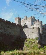 Cahir CastleHeritage attraction · 4.4 mi
Explorer Tom I came to Cahir carrying a spade; the Suir did the work first. Cahir Castle sits in the River Suir as though someone decided a moat should come ready made. Its name remembers an older stone fort, or cathair, and the later castle grew through O'Brien and Butler hands into one of Ireland's great fortified piles. In 1599 the Earl of Essex took it after a three day siege; in 1650 it surrendered to Cromwell without a shot. I'd have offered to guard the gate, but the Butlers might have checked my references. That is quite a change in negotiating style for the same walls. The Butlers kept shaping the place, and part of the Great Hall was rebuilt in the 1840s, so what you see carries several periods at once. The state heritage service offers visits and guided information; check the current opening and tour arrangements before travelling. From the bridge, look at the towers rising out of the water and try to work out which approach you would have chosen. Sensibly, choose the visitor entrance.
Siege of Cahir CastleSiege · 4.4 miExplorer Tom The Siege of Cahir Castle happened when someone got really angry about walls and probably ran out of bread. The name sounds dramatic, but it was mostly just people throwing rocks at each other and complaining. The castle is still there, pretending it didn’t get a bit of chipping. Pick a stone, any stone, and invent its biography.
 FarbreagaMountain / peak · 4.9 mi
Explorer Tom This second Farbreaga hosted the biggest dance in history, but someone kicked the fiddle player into the mist so hard he never recovered. Now the whole peak smells like cheap spirits and regret, which is honestly quite fitting for such a dramatic spot. It’s the ideal location for making a very dramatic phone call to your ex.
 GreenaneMountain / peak · 5.1 mi
Explorer Tom Greenane has an imaginary twin across the sea that it argues with every single day through the mist. They probably fight over whose shadow looks better on the horizon, which is just embarrassing for them both honestly. Take the long way round, because it definitely deserves the extra effort and the walk.
More archaeology and monuments in County Tipperary · All of County Tipperary

What do you know about this place?Tap to add a comment or ask a question