
Places near here
Photo credits
- National Inventory of Architectural Heritage
- Sarah777 at English Wikipedia, Wikimedia Commons · Public domain
- Ian Brooker and David Kleinig, Wikimedia Commons · CC BY 3.0 au
- surrealpenguin, Wikimedia Commons · CC BY-SA 2.0
- Sarah777, Wikimedia Commons · CC BY-SA 2.0
- 瑞丽江的河水, Wikimedia Commons · CC BY-SA 4.0
- Smirkybec, Wikimedia Commons · CC BY-SA 4.0
- Ryanforsyth9, Wikimedia Commons · CC BY-SA 4.0
 Hydepark HouseGates/railings/walls · 272 yd
Explorer Tom Hydepark House thinks its builder was secretly thinking about a holiday in Greece while constructing the wall. It looks a bit confused, as if it doesn’t know why it’s there at all. Enjoy the mystery of this architectural puzzle piece.
MoatArchaeological place · 737 ydExplorer Tom Moat in County Wexford would win a county fair by simply sitting there and looking slightly damp, which is more than most contestants can say for their entries. It’s the ultimate low-effort winner, relying on pure atmospheric dread to outdo any pie-eating champion or fancy dancing goat that dares to challenge its muddy dominance. Grand place for a sulk or a snog, your call.
St. Michaels WellHoly well · 1120 ydExplorer Tom St. Michaels Well in Clonough is having a huge drama with the nearest tree because the tree keeps dropping leaves into the stream. It’s just a natural spring on a steep slope, but it acts like it’s running a very serious water treatment plant. Linger, it's not going anywhere and neither should you.
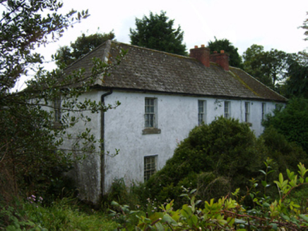 farm house1343 yd
Explorer Tom Farm house in Castletown is basically a mill’s best friend who never learned how to share the credit. It stands there looking symmetrical and proud, probably thinking about its 1840s dating profile where it listed 'adjacent industry' as a hobby. Flash a smile from afar before it gets shy.
 Tara HillMountain / peak · 2.2 mi
Explorer Tom Tara Hill holds the world record for being the most ignored hill in County Wexford, which is quite an achievement. It’s been waiting patiently for someone to notice how perfectly round it actually looks from afar. Ideal place to rehearse an excuse for being late.
 Johnston's gum3.3 mi
 Persian Walnut3.5 mi
Explorer Tom Persian Walnut in County Wexford had a fiddler playing all night until the locals threatened to throw rocks at him. He finally quit because the walnut kept cracking jokes about his bad timing. Bring a notebook and write the bit I made up.
 Arklow RockMountain / peak · 3.6 mi
Explorer Tom Arklow Rock is basically a giant stone bench where the seagulls hold council meetings to complain about the quality of local fish and chips. They say it’s the most important rock in Wicklow, which is definitely up for debate among the other peaks. Bring a notebook and write the bit I made up.
 The CoveBeach / strand · 4.4 mi
Explorer Tom The Cove in Arklow is incredibly proud of its ability to hide lost keys from everyone who drops them there without fail. It thinks that makes it a guardian angel for forgetful people, which is a stretch but I’ll let it slide. Go on, count the windows and get it wrong like I did.
 Battle of ArklowBattle · 4.8 mi
Explorer Tom The Battle of Arklow is where the local sheep have had strong opinions about men in red coats since 1798, mostly involving bleating and standing very still. It’s a field with a serious attitude problem regarding history. Bring the dog, it'll have opinions.
 Market HouseHeritage attraction · 5.2 mi
Explorer Tom Gorey’s Market House is the uncle at a wedding who stands by the cake looking confused about why everyone is dancing while he just wants a quiet drink. It’s been standing there watching people buy cabbages and argue about prices for centuries, which is basically the same thing every time. Take a mate and argue about what it was for.
 1798 MonumentMemorial · 5.5 mi
Explorer Tom This 1798 Monument has an imaginary twin across the sea that they argue about every time the wind picks up from the west. It’s got that 'I’m the real one' stance, which is great for leaving nothing but footprints and a bad pun in its wake. Leave nothing but footprints and a bad pun.
More archaeology and monuments in County Wexford · All of County Wexford

What do you know about this place?Tap to add a comment or ask a question