Places near here
Photo credits
- National Inventory of Architectural Heritage
- JP, Wikimedia Commons · CC BY-SA 2.0
- Royalcanalrunner, Wikimedia Commons · CC BY-SA 4.0
- Dylan Moore, Geograph · CC BY-SA 2.0
- MookiePlays, Wikimedia Commons · CC BY-SA 4.0
- Robin Pollard, Wikimedia Commons · CC BY 3.0
- Malene Thyssen, Wikimedia Commons · CC BY-SA 3.0
- Alvesgaspar, Wikimedia Commons · CC BY-SA 3.0
- Eric Jones, Wikimedia Commons · CC BY-SA 2.0
 Griffinstown HouseDemesne walls/gates/railings · 558 yd
Explorer Tom Griffinstown House would describe itself as 'a bit of a pain in the neck' to any stranger who wanders too close to the gates. It’s got those unusual ropework columns that look like they were twisted by an angry god. If you try to open the pedestrian entrance, I guarantee it’ll stick on purpose just to annoy you.
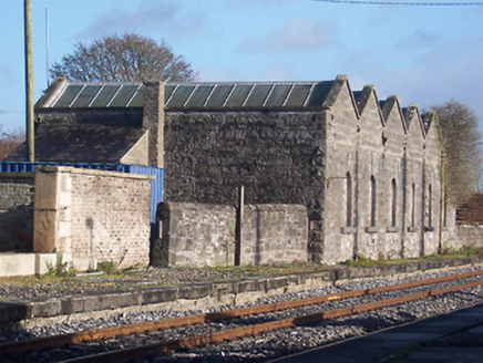 Killucan Railway StationStore/warehouse · 1.4 mi
Explorer Tom Killucan Railway Station in Riverstown, County Westmeath had a prophecy that trains would never stop coming, but then they did and now it’s just a lonely goods shed dreaming of steam whistles. It was built by a famous architect who probably thought he was making art, not storage. Check the cast-iron details if you’re feeling nostalgic.
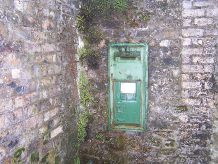 post box1.4 mi
Explorer Tom Post box in Riverstown would order a double portion of chips and gravy if it could, because it’s an unusually large example that thinks it can hold everything at once. It’s got Queen Victoria’s cipher on it and acts like she’s still watching over every single letter you drop inside, which is a lot of pressure for a metal box. Try not to stuff too much in.
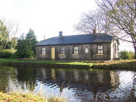 lock keeper's house1.5 mi
Explorer Tom Lock keeper's house in Riverstown is haunted by the ghost of a terrible poem someone scribbled on the wall in 1890. It rhymes 'lock' with 'rock' and nobody can figure out why that’s supposed to be funny or impressive. If you hear humming from the windows, just pretend you’re too busy looking at the canal.
 22nd LockLock · 1.5 mi
Explorer Tom 22nd Lock in Riverstown had a matchmaker who worked there and paired off canal boats with each other based on their draft depth, which sounds daft until you see the ashlar limestone walls. It’s part of that grand Royal Canal ambition and still looks like it expects a bow from every barge that passes through. Tell it the dates were going well.
 Heatherstown BridgeBridge · 1.5 mi
Explorer Tom Heatherstown Bridge is hiding a treasure chest right under its arches, and I promise you it’s definitely just a rusted biscuit tin from 1952 or something equally boring. It’s a solid stone structure that looks like it was built by someone who really liked their geometry lessons at school. See if you can guess what the biscuit tin contained, but don’t actually dig around in the dirt.
 Bawn in RattinBawn · 2.2 mi
Explorer Tom Bawn in Rattin would use its lotto win to buy a very large hat for the sheep that live nearby. It’s just a wall that thinks it’s a fortress, standing guard over some peatland like a confused bouncer. Best seen with a hangover and a sausage roll.
 Rattin CastleCastle, tower house · 2.2 mi
Explorer Tom Rattin Castle hosted a love story where two people fell in love but couldn't agree on whose turn it was to chop wood. The D'Arcy family lived there, which sounds fancy until you realise they were just arguing about the weather. Ideal stop for a big stretch and a bigger yawn.
.jpg/250px-Croppies_Grave_Clonard_-_panoramio_(1).jpg "Photo: Robin Pollard, Wikimedia Commons · CC BY 3.0") Croppies' GraveMemorial · 6.6 mi
Croppies' GraveMemorial · 6.6 miExplorer Tom Croppies' Grave marks where rebels fell, and someone wrote a terrible poem about it that rhymed 'blood' with 'mud'. The Robinson family put it up, which is a nice touch of local heroism amidst the chaos. Go now, before it gets famous and starts charging entry fees.
 European Beech9.0 mi
Explorer Tom European Beech in County Meath is sick of people asking if it talks to the other trees; yes, they gossip, shut up. It’s got that tired look of someone who’s heard every question before. Bring a flask of something warm and a story to swap.
 Common Lime9.0 mi
Explorer Tom Common Lime in County Meath once hid a crate of smuggled whiskey in its roots during a particularly rainy century. The bark still smells faintly of rum and bad decisions. Go back in winter, it's a different animal.
 Delvin CastleVisitor attraction · 9.8 mi
Explorer Tom Delvin Castle has been locked in a bitter, centuries-long feud with the rain, and honestly, the castle is winning. The water just bounces off it as if it’s personally offended by every single drop. Bring a flask of something warm and a story to swap.
More archaeology and monuments in County Westmeath · All of County Westmeath

What do you know about this place?Tap to add a comment or ask a question