Places near here
Photo credits
- National Inventory of Architectural Heritage
- Algirdas at Lithuanian Wikipedia, Wikimedia Commons · Public domain
- Dieglop, Wikimedia Commons · CC BY-SA 4.0
- Tjp finn, Wikimedia Commons · CC BY-SA 4.0
- EecherplazGinkgo06.jpg : Cayambe derivative work: Ginkgotree ( talk ), Wikimedia Commons · CC BY-SA 3.0
- jai, Wikimedia Commons · CC BY-SA 2.0
- Sitomon, Wikimedia Commons · CC BY-SA 2.0
- Mike Searle, Wikimedia Commons · CC BY-SA 2.0
- Wanfried-Dublin, Wikimedia Commons · CC BY-SA 4.0
- Sitomon, Wikimedia Commons · Public domain
- David Brossard, Wikimedia Commons · CC BY-SA 2.0
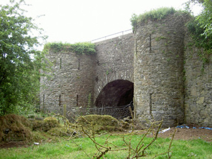 bridge2.3 mi
Explorer Tom Bridge in Collon looks unassuming from the road but its abutments are massive and secretly judging your driving. A cow once tried to buy it because it liked the stone texture. Bring a camera and your most skeptical face.
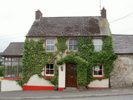 Forge HouseHouse · 2.4 mi
Explorer Tom Forge House in Collon is preparing its resume for a job interview, highlighting its scalloped porch tiles as key skills. The old forge next door is gone, but the turntable base remains like a ghost with a purpose. Stick around for the quiet drama of that empty space.
 Pedunculate Oak2.6 mi
Explorer Tom Pedunculate Oak in County Meath says there’s a curse on anyone who doesn’t wave to it first. It’s got long acorns and an even longer memory for rudeness from passersby. Go now, before it gets famous.
 MonasteryEcclesiastical residence · 3.1 mi
 Saint Patrick's Fire: Hill of SlaneLegend location · 3.2 mi
Explorer Tom Saint Patrick's Fire: Hill of Slane has Patrick lighting his Easter flame before the king's fire on Tara. No wonder the story says Laoghaire was furious. I love a grand entrance, but I might have sent a note first.
 Ginkgo3.2 mi
Explorer Tom This Ginkgo in County Meath would post photos of its leaves with captions like 'living fossil, no filter needed.' It’s basically a dinosaur tree that thinks it’s very trendy and modern. Pick a stone, any stone, and invent its biography.
 Mellifont AbbeyVisitor attraction · 3.3 mi
 Slane CastleCastle · 3.8 mi
 Fennor CastleCastle · 4.3 mi
 Druids AltarPortal tomb · 4.6 mi
Explorer Tom Druids Altar in Rathkenny hosted a fiddler who played all night without stopping. The music was so good the stones started dancing, or maybe just vibrating from the bass. Give it a pat on the way past, it's had a long life.
 KnowthArchaeological place · 4.7 mi
 Oengus Óg: NewgrangeLegend location · 5.4 mi
Explorer Tom Oengus Óg: Newgrange gives this ancient monument a love story with a very odd ending: he finds Caer as a swan, becomes one himself and flies home with her. I was ready for a romantic walk; Oengus went straight for wings. Fair play to him.
More archaeology and monuments in County Meath · All of County Meath

What do you know about this place?Tap to add a comment or ask a question