Places near here
Photo credits
- National Inventory of Architectural Heritage
- Algirdas at Lithuanian Wikipedia, Wikimedia Commons · Public domain
- Willow, Wikimedia Commons · CC BY 2.5
- jai, Wikimedia Commons · CC BY-SA 2.0
- Willard Rome, Geograph · CC BY-SA 2.0
- Colin Park, Geograph · CC BY-SA 2.0
- Lior Kogan, Wikimedia Commons · CC BY-SA 4.0
- Jan van Huchtenburgh, Wikimedia Commons · Public domain
- Martin Richard Phelan, Wikimedia Commons · CC BY-SA 2.0
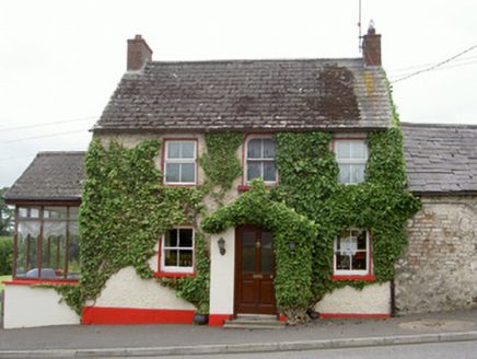 Forge HouseHouse · 109 yd
Explorer Tom Forge House in Collon is preparing its resume for a job interview, highlighting its scalloped porch tiles as key skills. The old forge next door is gone, but the turntable base remains like a ghost with a purpose. Stick around for the quiet drama of that empty space.
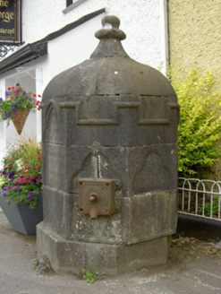 fountain177 yd
Explorer Tom Fountain in Collon is what Saint Patrick would call ‘a bit much’ with all that water splashing about. It was a gift from a vicar who probably needed to show off. Have a chat with the statue, he’s not biting.
Black HillMountain / peak · 1456 ydExplorer Tom Black Hill thinks tourists from Dublin are mostly just lost people who think wearing a flat cap makes them look like they know what they're doing. Ideal stop for a big stretch and a bigger yawn.
 Pedunculate Oak1533 yd
Explorer Tom Pedunculate Oak in County Meath has very strong opinions on modern buildings and thinks they’re all just cardboard boxes on stilts. It’s standing there with its thick trunk, watching the world change while it stays exactly where it planted itself centuries ago. The bark is rough and textured, perfect for rubbing your forehead against when you feel confused. Bring a notebook and write the bit I
 European ash2.4 mi
Explorer Tom European ash in County Louth was once a matchmaker who worked under its branches, pairing off locals with questionable taste. Bring wellies and low expectations, leave delighted by the absolute chaos of romance it orchestrated here.
 Mellifont AbbeyVisitor attraction · 2.5 mi
Explorer Tom Mellifont Abbey in County Louth was nearly sold to pay for a horse that ran off with a nun. The monks were furious but the deal went through anyway. Bring a flask and pretend you own the place.
 Round Tower2.8 mi
Explorer Tom Monasterboice round tower lost a bet with a priest who claimed he could climb it in his slippers. It’s still standing tall, though, proving that height beats confidence every single time. Take a mate and argue about what it was for.
 Monasterboice Round TowerHeritage attraction · 2.8 mi
Explorer Tom Monasterboice Round Tower has decided its New Year's resolution is to stop being so tall and start being more approachable, which is hard when you’re stone. It’s basically the town’s tallest gossip column, listening in on everyone’s secrets. Bring a pen pal, they'll be jealous.
 Stone CrossesCross, High cross · 2.9 mi
Explorer Tom Monasterboice stone crosses would file a complaint with the council about the amount of tourists taking selfies on them. They’re ancient sculptures, not a photo backdrop for your holiday album. Go before the tourists find out.
 Battle of the Boyne Visitor CentreMuseum · 4.5 mi
Explorer Tom The Battle of the Boyne Visitor Centre has a New Year's resolution to stop pretending it’s not just a house with a lot of history stuffed into it. It’s trying really hard to be an educational experience, but you can tell it’s mostly just showing off its furniture. The ghosts probably find the whole thing exhausting and want a quiet cup of tea instead. Look
_tussen_Jacobus_II_en_Willem_III,_12_juli_1690_Rijksmuseum_SK-A-605.jpeg/250px-De_slag_aan_de_Boyne_(Ierland)_tussen_Jacobus_II_en_Willem_III,_12_juli_1690_Rijksmuseum_SK-A-605.jpeg "Photo: Jan van Huchtenburgh, Wikimedia Commons · Public domain") Battle of the BoyneMajor battlefield · 4.5 mi
Battle of the BoyneMajor battlefield · 4.5 miExplorer Tom The Battle of the Boyne would have a dating profile saying 'Lover of cannon fire, seeking someone who won't run away from commitment.' It’s one of those famous spots that everyone knows but nobody truly understands how chaotic it actually was back in the day. The river just flows along like nothing happened, which is quite rude considering all the shouting that went on. Bring
 Dowth CastleCastle, tower house · 5.2 mi
Explorer Tom Dowth Castle in Dowth has been sitting on that ridge since 1234, looking smug about it. Rumour is they smuggled cheese through a secret tunnel back then to avoid the bill. Stop the car, it’s worth the hazard lights.
More historic places in County Louth · All of County Louth

What do you know about this place?Tap to add a comment or ask a question