Places near here
Photo credits
- Photo-raven, Wikimedia Commons · CC BY-SA 4.0
- Hywel Williams, Geograph · CC BY-SA 2.0
- National Inventory of Architectural Heritage
- Ftlombardo, Wikimedia Commons · CC BY 3.0
- Willow, Wikimedia Commons · CC BY 2.5
- Mac McCarron, Geograph · Creative Commons Attribution-ShareAlike 2.0
- Jonathan Thacker, Geograph · CC BY-SA 2.0
- N Chadwick, Geograph · Creative Commons Attribution-ShareAlike 2.0
- Mac McCarron, Geograph · CC BY-SA 2.0
 Ballysaggartmore HouseOfficially recorded historic building · 869 yd
Explorer Tom Ballysaggartmore House is a Gothic gateway that thinks Dublin tourists are all drama queens. It’s got flanking lodges that look like they’re posing for a magazine shoot. The stone masonry is top-notch, so give it a proper nod!
 Ballysaggartmore TowersVisitor information · 953 yd
Explorer Tom Ballysaggartmore Towers in County Waterford hosted a dramatic incident where a goat stole the keys to the gatehouse. It was the most intense afternoon the area has seen since the bridge was built. Take a mate and argue about what it was for.
 Fort WilliamStables · 1381 yd
Explorer Tom Fort William stables would cope on a reality show by refusing to talk, eating all the food, and sleeping in the most comfortable corner while the cameras zoom in on its group value. It’s part of the estate setting, but mostly it’s just playing hard to get for the audience. Flash a camera; it’ll pretend not to see you!
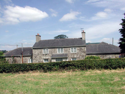 Lismore CastleFarm house · 1433 yd
Explorer Tom Lismore Castle’s farmhouse would use its lotto win to install a very discreet dovecote that actually sings opera. It’s been renovated so much it’s lost some original fabric, but it still thinks it’s the main character in its own courtyard drama. Just watch the pigeons, they're plotting.
LismoreMemorial · 1453 ydExplorer Tom The whole parish used to argue about this Lismore memorial until everyone got tired of shouting. Now it just stands there, enjoying the peace and quiet after all that drama. Bring sandwiches, the gulls will thank you.
Cottage IslandIslet · 1.0 miExplorer Tom Cottage Island is hosting a surprise party for itself because it’s tiny enough to fit in your pocket if you fold the map right. I heard its celebrity cousin, Brendan Behan, used to leave his hat there whenever he lost a bet. Dare you to say hello to it out loud.
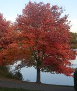 Red Maple1.1 mi
Explorer Tom Red Maple in County Waterford is incredibly proud of being a Red Maple in a place where red is mostly just the colour of the sunset. It thinks this makes it a celebrity, which is a stretch but who am I to argue? Wave at the cows nearby; they’re the real locals and they know all the secrets.
 European ash1.1 mi
Explorer Tom European ash in County Waterford is probably hearing everything from the seagulls, who seem to use it as their main gossip station. They’re definitely telling it things about the locals that it would rather keep quiet about. Dare you to say hello to it out loud.
 Holy well in Lismore (coshmore and Coshbride By.)Holy well · 1.1 mi
Explorer Tom Holy well in Lismore got swapped out for another well when they diverted the water a century ago, which is pure betrayal if you ask me. It would survive a zombie attack by hiding under the bluff and letting the monsters fight over the wrong location entirely, probably laughing at them. Give it a pat on the way past, it's had a long life.
 Ambrose Power MemorialMemorial · 1.2 mi
Explorer Tom Ambrose Power Memorial in County Waterford stands at a busy junction where traffic goes faster than his escape plan could ever hope to match. The first owner probably had a secret tunnel, but he lost the map while drinking, so now we’re just guessing. Get a photo with it before it gets a better agent who knows what to do with all that stone.
 St. Carthaghs WellHoly well · 1.2 mi
Explorer Tom St. Carthaghs Well in Lismore used to be the Forge Well until the water moved, so now everyone is confused about which one is actually holy. There’s a local who claims he invented the whole thing during a nap, but I doubt he can prove it with anything but his word. Look serious, nod slowly, you're basically an expert now.
 Lady Louisa's WalkWalking route · 1.4 mi
Explorer Tom Lady Louisa's Walk would order extra ketchup and a side of attitude if it went to a chippy, demanding her chips be perfectly crispy and her tea scalding hot. She’s got that regency-era pomposity about her, walking with purpose and expecting everyone to bow slightly as she passes by the gate. If it rains, blame me.
More castles and forts in County Waterford · All of County Waterford

What do you know about this place?Tap to add a comment or ask a question