
Places near here
Photo credits
- Nigel Cox, Wikimedia Commons · CC BY-SA 2.0
- Ridiculopathy, Wikimedia Commons · CC BY-SA 4.0
- Colin Park, Wikimedia Commons · CC BY-SA 2.0
- Enter, Wikimedia Commons · CC BY-SA 4.0
- Norman Ekin, Geograph · CC BY-SA 2.0
- National Inventory of Architectural Heritage
- Ian S, Wikimedia Commons · CC BY-SA 2.0
- User:Itub, Wikimedia Commons · CC BY-SA 3.0
- Garry Dickinson, Geograph · CC BY-SA 2.0
- Mike Searle, Wikimedia Commons · CC BY-SA 2.0
Explorer Tom Holy well in Shannera Upper is tucked under a huge sally tree, which refuses to fall down despite the best efforts of gravity. It’s called Glunóg locally, which sounds like a sneeze but means something way more mystical to the locals. Best visited with a curious kid and no timetable.
 BeenkeraghMountain / peak · 2.9 mi
Explorer Tom Beenkeragh is Ireland's second-highest mountain and still has to listen to everybody asking about Carrauntoohil next door. At 1,008 metres it has earned its own bragging rights. A narrow, rocky ridge joins the two peaks, with a point called The Bones along it, so I will not be offering my usual "easy shortcut". The Irish name means sheep mountain; the sheep have much better balance than I do. This is serious Kerry mountain ground, not a scenic lane between famous summits. Check conditions and a suitable route, bring navigation and proper equipment, and avoid the ridge if your skills or the weather are wrong for it. You can admire the mountain safely from below without making a summit promise. Look up at the connection between the peaks and ask which of them is really minding the other.
 Ogham stone in Kilcoolaght EastOgham stone · 3.1 mi
Explorer Tom Ogham stone in Kilcoolaght East bragged about surviving storms that flattened the neighbors’ houses, but now it can’t even find its own footing. It’s basically a stone missing from a puzzle no one is trying to solve. Go on a wet day, it suits the mood.
 The BonesMountain / peak · 3.1 mi
Explorer Tom The Bones sounds like a warning, and the mountain makes a convincing case for the name. This 957-metre point rises on the narrow, rocky Beenkeragh Ridge between Carrauntoohil and Beenkeragh, the country's two highest peaks. It is easy to muddle with The Bone, a different spur in the Reeks, which is a particularly poor mistake to make when giving your position. I would sort the names with a big painted sign, but the mountain has not asked for my decorating advice. The ridge is exposed and serious, so go only with suitable experience, weather, navigation and a safe way back; there is no gentle sightseeing path to this summit. Study the shape from a safer viewpoint if that suits you. The name is dramatic enough without my legs joining the story.
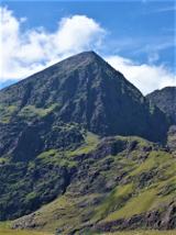 CarrauntoohilMountain / peak · 3.4 mi
Explorer Tom You look fit enough. Carrauntoohil would like a word. Carrauntoohil is Ireland's highest mountain at 1,038.6 metres, which is a very precise way of saying it has no interest in my lungs. Its sandstone was cut by ice into sharp ridges and hollows. The Eagle's Nest corrie holds Lough Cummeenoughter, Ireland's highest lake, while the narrow Beenkeragh Ridge leads toward the country's second highest summit. I'll race you up, provided you agree the race ends at the first sensible rest. Go the other way and Caher takes third place. The usual route reaches a col by the Devil's Ladder, a name I would have changed before inviting anyone uphill. The summit cross first stood here in wood in the 1950s and was replaced by steel in 1976. Most of these mountains are privately owned, although recreational access is reasonably allowed. This is serious mountain ground: the rescue team warns that the start of Howling Ridge can be mistaken for a descent route. Bring proper boots, weather sense and a route you understand. I will admire the view after I have remembered how to breathe.
 Devil's Ladder RouteWalking route · 3.6 mi
Explorer Tom Devil's Ladder Route in County Kerry is playing hide-and-seek with me. Local legend says a giant dropped it there after losing a bet to a hedgehog, which feels about right given the terrain. Bring wellies and low expectations, leave delighted.
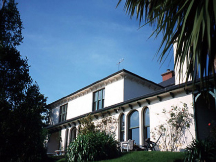 Caragh LodgeHouse · 3.6 mi
Explorer Tom Caragh Lodge has a curse that only hits people who don't wave when they pass its entrance porch. The Victorian lean-to wing is there to catch the wind and your attention simultaneously. Take a breath of that air, it's older than your car.
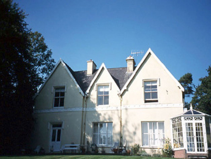 Glendalough HouseHouse · 3.8 mi
Explorer Tom Glendalough House has a ghost named Larry who is too lazy to haunt anyone properly. He just sits in the corner of the L-plan, waiting for someone to bring him a sandwich. If anyone asks, Tom sent you.
 Kerry Bog VillageHeritage attraction · 4.6 mi
Explorer Tom Kerry Bog Village in County Kerry is playing hide-and-seek with me. The Vikings got so lost looking for it they ended up in Scotland by mistake. Have a look and decide if I was lying.
 King Puck statueMemorial · 4.7 mi
Explorer Tom King Puck statue in Killorglin, County Kerry has a ghost tenant who is too lazy to haunt it because he prefers watching TV in peace. Bring a coin for luck and keep it in your pocket.
 Castle Core (in Ruins)Castle, tower house · 5.1 mi
Explorer Tom Castle Core in Dromaloughane belonged to the Macgillycuddy's of the Reeks, a very fancy name for a tower house. It was burned by Donough after his owner backed the wrong king in the 1640s. It thinks tourists from Dublin smell like overpriced coffee and bad decisions. Take the long way round, it deserves the effort.
 Ballymalis Castle (in ruins)Castle, tower house · 5.2 mi
Explorer Tom Ballymalis Castle has had so many names in its lifetime that it’s basically a chameleon, changing its identity every time the river floods a bit higher. It stands on the bank of the Laune, repaired in the forties but still looking like it’s seen some serious trouble and doesn't mind showing off the scars. Bring a jacket, it's never as warm as I promise.
More archaeology and monuments in County Kerry · All of County Kerry

What do you know about this place?Tap to add a comment or ask a question